Galloway Topo Map Missouri
To zoom in, hover over the map of Galloway
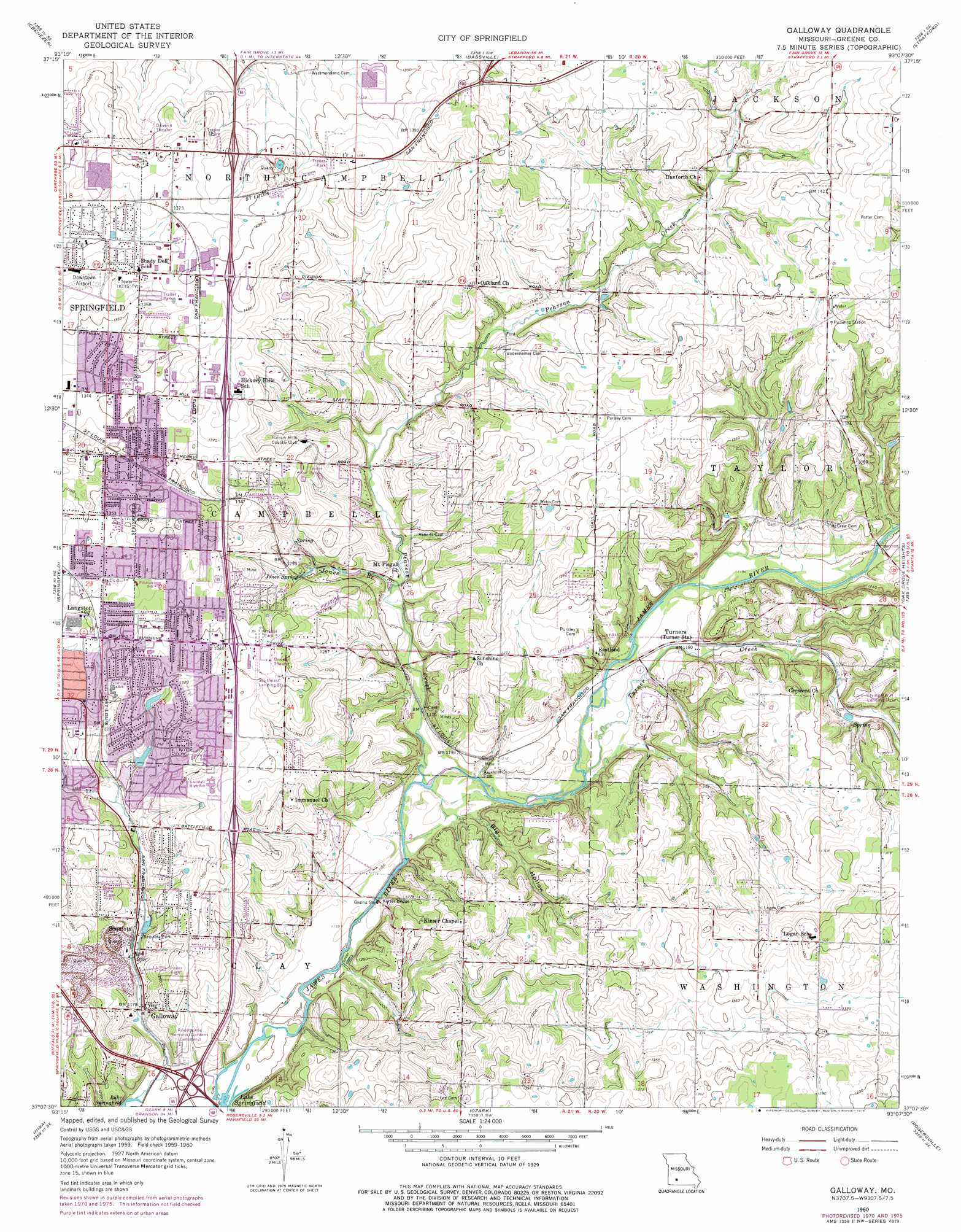
USGS Topo Quad 37093b2 - 1:24,000 scale
| Topo Map Name: | Galloway |
| USGS Topo Quad ID: | 37093b2 |
| Print Size: | ca. 21 1/4" wide x 27" high |
| Southeast Coordinates: | 37.125° N latitude / 93.125° W longitude |
| Map Center Coordinates: | 37.1875° N latitude / 93.1875° W longitude |
| U.S. State: | MO |
| Filename: | o37093b2.jpg |
| Download Map JPG Image: | Galloway topo map 1:24,000 scale |
| Map Type: | Topographic |
| Topo Series: | 7.5´ |
| Map Scale: | 1:24,000 |
| Source of Map Images: | United States Geological Survey (USGS) |
| Alternate Map Versions: |
Galloway MO 1937 Download PDF Buy paper map Galloway MO 1937, updated 1957 Download PDF Buy paper map Galloway MO 1948, updated 1948 Download PDF Buy paper map Galloway MO 1960, updated 1961 Download PDF Buy paper map Galloway MO 1960, updated 1971 Download PDF Buy paper map Galloway MO 1960, updated 1975 Download PDF Buy paper map Galloway MO 1960, updated 1976 Download PDF Buy paper map Galloway MO 1996, updated 2000 Download PDF Buy paper map Galloway MO 2011 Download PDF Buy paper map Galloway MO 2015 Download PDF Buy paper map |
1:24,000 Topo Quads surrounding Galloway
Morrisville |
Pleasant Hope |
Fair Grove |
Elkland |
Beach |
Willard |
Ebenezer |
Bassville |
Strafford |
Marshfield |
Brookline |
Springfield |
Galloway |
Oak Grove Heights |
Fordland |
Republic |
Nixa |
Ozark |
Rogersville |
Bruner |
Hurley |
Highlandville |
Selmore |
Chadwick |
Keltner |
> Back to 37093a1 at 1:100,000 scale
> Back to 37092a1 at 1:250,000 scale
> Back to U.S. Topo Maps home
Galloway topo map: Gazetteer
Galloway: Airports
Downtown Airport elevation 418m 1371′Flying Bar H Ranch Airport elevation 406m 1332′
Vans Heliport elevation 424m 1391′
Galloway: Bridges
Kinser Bridge elevation 350m 1148′Galloway: Dams
Ford Lake Dam elevation 416m 1364′John Q McLean, Lee and Hammons Lake Number 3 Dam elevation 375m 1230′
Leo Journagan Lake Dam elevation 407m 1335′
Galloway: Parks
Glenwood Park elevation 411m 1348′Sequiota Park elevation 366m 1200′
Springfield Conservation Nature Center elevation 368m 1207′
Galloway: Populated Places
Expansion elevation 379m 1243′Galloway elevation 359m 1177′
Langston elevation 410m 1345′
Mumford elevation 364m 1194′
Sequiota elevation 368m 1207′
Turners elevation 364m 1194′
Galloway: Reservoirs
Ford Lake elevation 416m 1364′Galloway: Springs
Jones Spring elevation 386m 1266′Galloway: Streams
East Branch Galloway Creek elevation 375m 1230′Galloway Creek elevation 348m 1141′
Jones Branch elevation 362m 1187′
Mustard Branch elevation 408m 1338′
Pierson Creek elevation 352m 1154′
Sequiota Spring Branch elevation 361m 1184′
Turner Creek elevation 354m 1161′
West Branch Galloway Creek elevation 374m 1227′
Galloway: Valleys
Big Hollow elevation 358m 1174′Galloway digital topo map on disk
Buy this Galloway topo map showing relief, roads, GPS coordinates and other geographical features, as a high-resolution digital map file on DVD: