Strafford Topo Map Missouri
To zoom in, hover over the map of Strafford
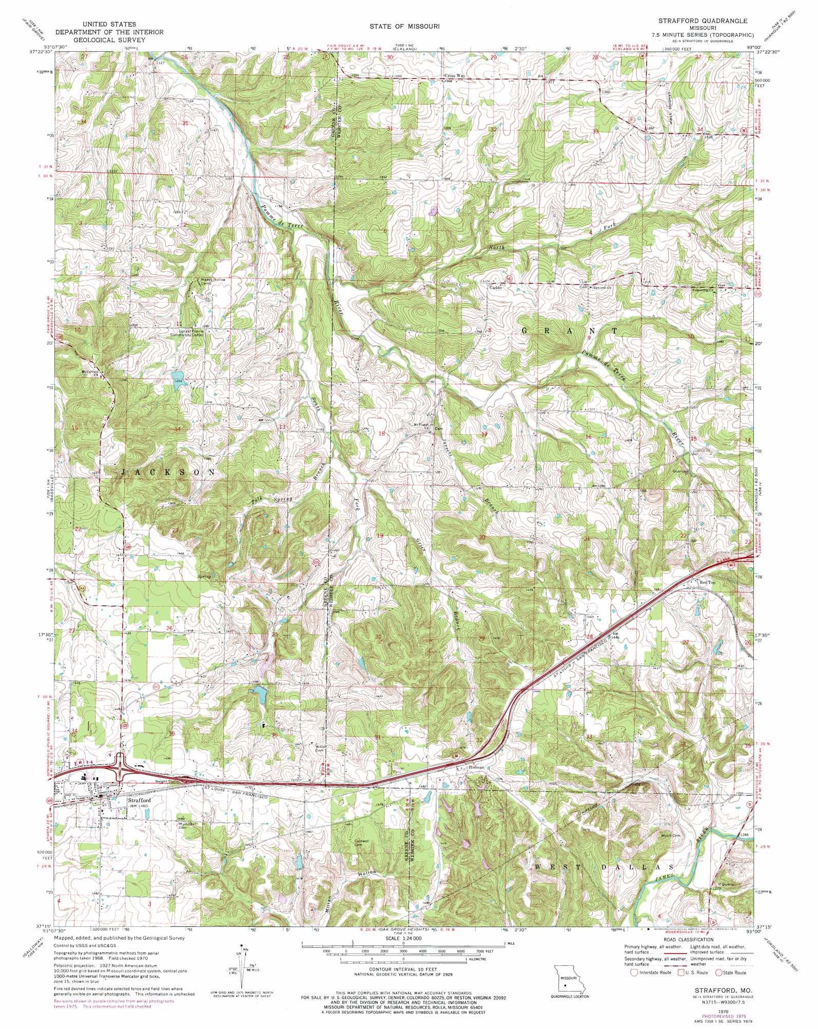
USGS Topo Quad 37093c1 - 1:24,000 scale
| Topo Map Name: | Strafford |
| USGS Topo Quad ID: | 37093c1 |
| Print Size: | ca. 21 1/4" wide x 27" high |
| Southeast Coordinates: | 37.25° N latitude / 93° W longitude |
| Map Center Coordinates: | 37.3125° N latitude / 93.0625° W longitude |
| U.S. State: | MO |
| Filename: | o37093c1.jpg |
| Download Map JPG Image: | Strafford topo map 1:24,000 scale |
| Map Type: | Topographic |
| Topo Series: | 7.5´ |
| Map Scale: | 1:24,000 |
| Source of Map Images: | United States Geological Survey (USGS) |
| Alternate Map Versions: |
Strafford MO 1970, updated 1971 Download PDF Buy paper map Strafford MO 1970, updated 1976 Download PDF Buy paper map Strafford MO 2011 Download PDF Buy paper map Strafford MO 2015 Download PDF Buy paper map |
1:24,000 Topo Quads surrounding Strafford
Cedar Vista |
Half Way |
Charity |
Long Lake |
Phillipsburg |
Pleasant Hope |
Fair Grove |
Elkland |
Beach |
Niangua |
Ebenezer |
Bassville |
Strafford |
Marshfield |
High Prarie |
Springfield |
Galloway |
Oak Grove Heights |
Fordland |
Seymour |
Nixa |
Ozark |
Rogersville |
Bruner |
Dogwood |
> Back to 37093a1 at 1:100,000 scale
> Back to 37092a1 at 1:250,000 scale
> Back to U.S. Topo Maps home
Strafford topo map: Gazetteer
Strafford: Dams
Circle Lake Dam elevation 449m 1473′Elk Lake Dam elevation 453m 1486′
Great Bear Lake Dam elevation 416m 1364′
Hardeke Lake Dam elevation 382m 1253′
Hilliard Estates Lake Dam elevation 427m 1400′
Lake Ralph Foster Dam elevation 436m 1430′
Lost Lake Dam elevation 425m 1394′
Mueller Lake Dam elevation 408m 1338′
Salisbury Lake Dam elevation 411m 1348′
Strafford: Populated Places
Caddo elevation 402m 1318′Cross Way elevation 410m 1345′
Holman elevation 460m 1509′
Red Top elevation 452m 1482′
Strafford elevation 454m 1489′
Strafford: Reservoirs
Hardeke Lake elevation 382m 1253′Hilliard Estates Lake elevation 427m 1400′
Jones Lake elevation 416m 1364′
Mueller Lake elevation 408m 1338′
Salisbury Lake elevation 411m 1348′
Strafford: Streams
Grier Branch elevation 367m 1204′Jarrett Branch elevation 357m 1171′
North Carolina Creek elevation 380m 1246′
North Fork Pomme de Terre River elevation 350m 1148′
Polk Spring Branch elevation 365m 1197′
South Fork Pomme de Terre River elevation 345m 1131′
Strafford: Summits
North View Hill elevation 444m 1456′Strafford digital topo map on disk
Buy this Strafford topo map showing relief, roads, GPS coordinates and other geographical features, as a high-resolution digital map file on DVD: