Baxter Springs Topo Map Kansas
To zoom in, hover over the map of Baxter Springs
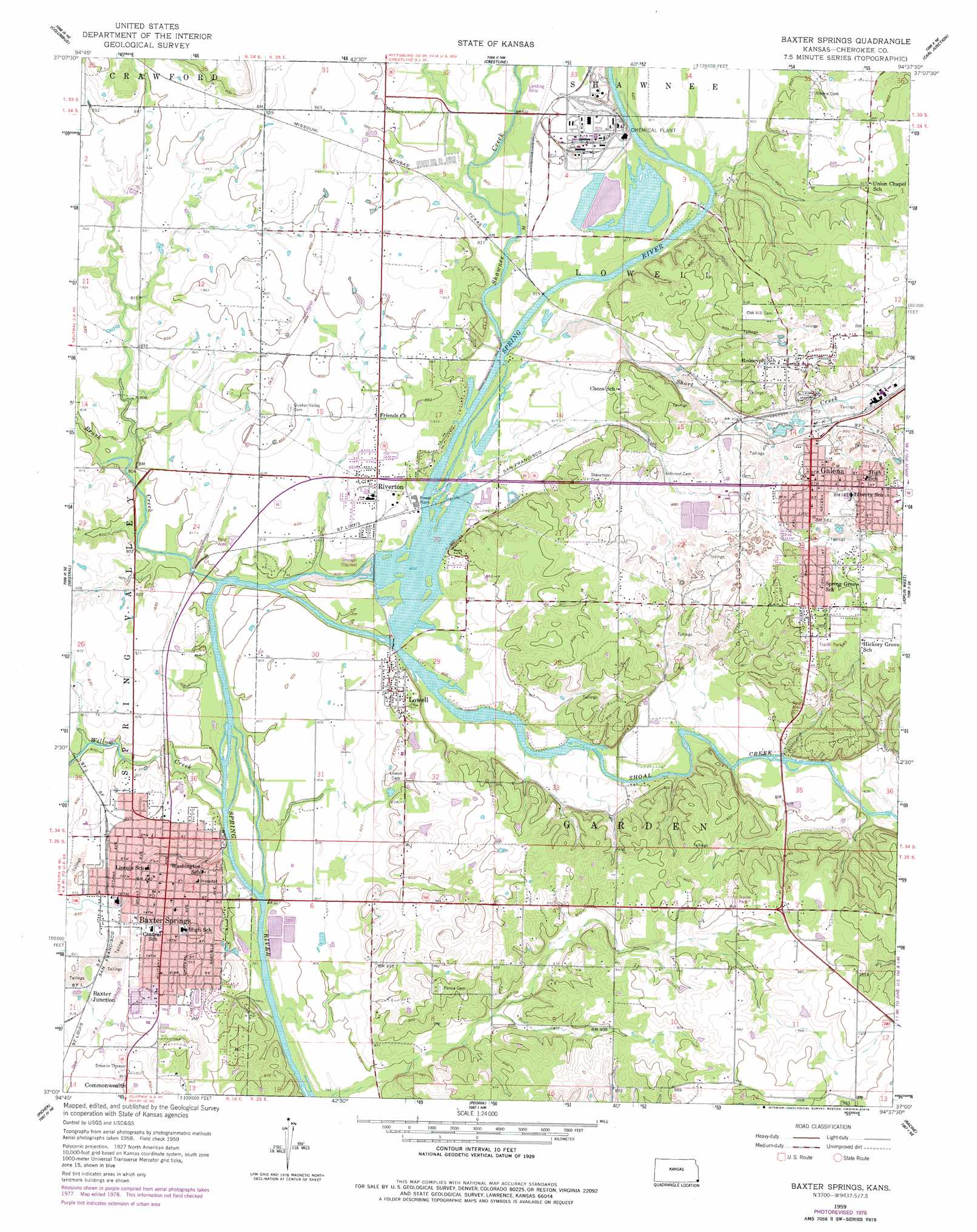
USGS Topo Quad 37094a6 - 1:24,000 scale
| Topo Map Name: | Baxter Springs |
| USGS Topo Quad ID: | 37094a6 |
| Print Size: | ca. 21 1/4" wide x 27" high |
| Southeast Coordinates: | 37° N latitude / 94.625° W longitude |
| Map Center Coordinates: | 37.0625° N latitude / 94.6875° W longitude |
| U.S. State: | KS |
| Filename: | o37094a6.jpg |
| Download Map JPG Image: | Baxter Springs topo map 1:24,000 scale |
| Map Type: | Topographic |
| Topo Series: | 7.5´ |
| Map Scale: | 1:24,000 |
| Source of Map Images: | United States Geological Survey (USGS) |
| Alternate Map Versions: |
Baxter Springs KS 1959, updated 1960 Download PDF Buy paper map Baxter Springs KS 1959, updated 1979 Download PDF Buy paper map Baxter Springs KS 2010 Download PDF Buy paper map Baxter Springs KS 2012 Download PDF Buy paper map Baxter Springs KS 2015 Download PDF Buy paper map |
1:24,000 Topo Quads surrounding Baxter Springs
West Mineral |
Cherokee |
Kirkwood |
Asbury |
Neck City |
Hallowell |
Columbus |
Crestline |
Carl Junction |
Webb City |
Melrose |
Neutral |
Baxter Springs |
Joplin West |
Joplin East |
Miami Nw |
Picher |
Peoria |
Racine |
Tipton Ford |
Miami Sw |
Miami Se |
Wyandotte |
Seneca |
Neosho West |
> Back to 37094a1 at 1:100,000 scale
> Back to 37094a1 at 1:250,000 scale
> Back to U.S. Topo Maps home
Baxter Springs topo map: Gazetteer
Baxter Springs: Bridges
Boston Mills Bridge elevation 246m 807′Porters Bridge elevation 250m 820′
Ryan Bridge (historical) elevation 246m 807′
Baxter Springs: Populated Places
Baxter Junction elevation 255m 836′Baxter Springs elevation 257m 843′
Commonwealth elevation 258m 846′
East Galena elevation 296m 971′
Empire City elevation 290m 951′
Galena elevation 275m 902′
Lowell elevation 260m 853′
Quakervale (historical) elevation 257m 843′
Riverton elevation 254m 833′
South Galena elevation 294m 964′
Baxter Springs: Reservoirs
Lowell Reservoir elevation 242m 793′Baxter Springs: Springs
Baxter Springs elevation 256m 839′Baxter Springs: Streams
Brush Creek elevation 242m 793′Shawnee Creek elevation 246m 807′
Shoal Creek elevation 246m 807′
Short Creek elevation 269m 882′
Short Creek elevation 247m 810′
Willow Creek elevation 238m 780′
Baxter Springs digital topo map on disk
Buy this Baxter Springs topo map showing relief, roads, GPS coordinates and other geographical features, as a high-resolution digital map file on DVD: