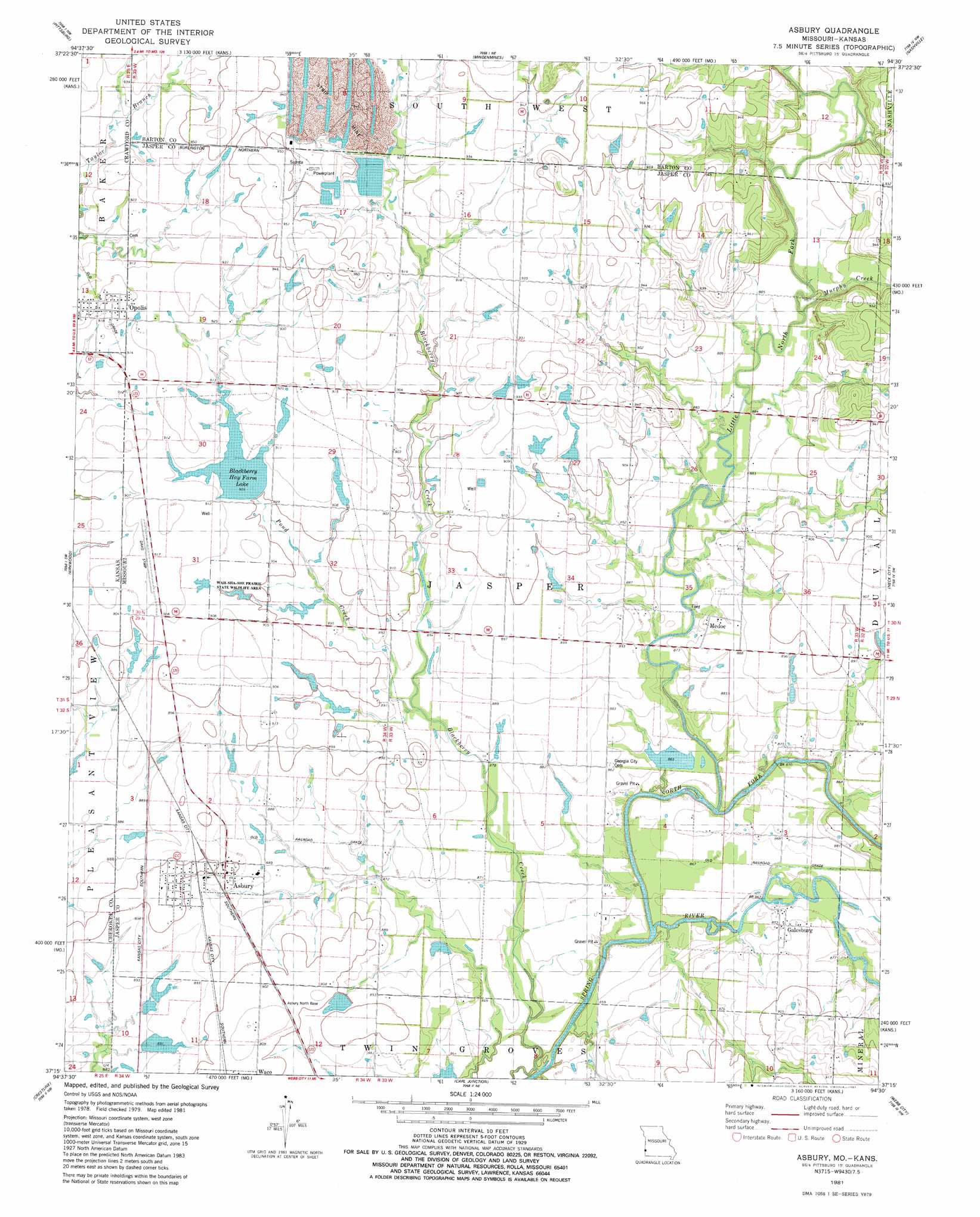
Asbury Topo Map Missouri
To zoom in, hover over the map of Asbury
USGS Topo Quad 37094c5 - 1:24,000 scale
| Topo Map Name: | Asbury |
| USGS Topo Quad ID: | 37094c5 |
| Print Size: | ca. 21 1/4" wide x 27" high |
| Southeast Coordinates: | 37.25° N latitude / 94.5° W longitude |
| Map Center Coordinates: | 37.3125° N latitude / 94.5625° W longitude |
| U.S. States: | MO, KS |
| Filename: | o37094c5.jpg |
| Download Map JPG Image: | Asbury topo map 1:24,000 scale |
| Map Type: | Topographic |
| Topo Series: | 7.5´ |
| Map Scale: | 1:24,000 |
| Source of Map Images: | United States Geological Survey (USGS) |
| Alternate Map Versions: |
Asbury MO 1981, updated 1981 Download PDF Buy paper map Asbury MO 2010 Download PDF Buy paper map Asbury MO 2011 Download PDF Buy paper map Asbury MO 2015 Download PDF Buy paper map |
1:24,000 Topo Quads surrounding Asbury
Girard |
Arma |
Liberal |
Iantha |
Lamar North |
Radley |
Pittsburg |
Mindenmines |
Nashville |
Lamar South |
Cherokee |
Kirkwood |
Asbury |
Neck City |
Jasper |
Columbus |
Crestline |
Carl Junction |
Webb City |
Carthage |
Neutral |
Baxter Springs |
Joplin West |
Joplin East |
Fidelity |
> Back to 37094a1 at 1:100,000 scale
> Back to 37094a1 at 1:250,000 scale
> Back to U.S. Topo Maps home
Asbury topo map: Gazetteer
Asbury: Areas
Cherokee Plains elevation 287m 941′Asbury: Dams
Asbury Farms Dam elevation 261m 856′Blackberry Hay Farm Dam elevation 268m 879′
Doran Lake Dam elevation 262m 859′
Herr Lake Dam elevation 273m 895′
Raymond Smith Dam elevation 274m 898′
Asbury: Parks
Wah-Sha-She Prairie State Wildlife Area elevation 274m 898′Asbury: Populated Places
Asbury elevation 274m 898′Galesburg elevation 266m 872′
Medoc elevation 269m 882′
Opolis elevation 284m 931′
Asbury: Reservoirs
Asbury Farms Lake elevation 261m 856′Blackberry Hay Farm Lake elevation 276m 905′
Browning West Lake elevation 268m 879′
Doran Lake elevation 262m 859′
Herr Lake elevation 273m 895′
Raymond Smith Lake elevation 274m 898′
Asbury: Streams
Blackberry Creek elevation 258m 846′Little North Fork elevation 259m 849′
Murphy Creek elevation 266m 872′
North Fork Spring River elevation 259m 849′
Pond Creek elevation 268m 879′
Asbury digital topo map on disk
Buy this Asbury topo map showing relief, roads, GPS coordinates and other geographical features, as a high-resolution digital map file on DVD: