Eldorado Springs North Topo Map Missouri
To zoom in, hover over the map of Eldorado Springs North
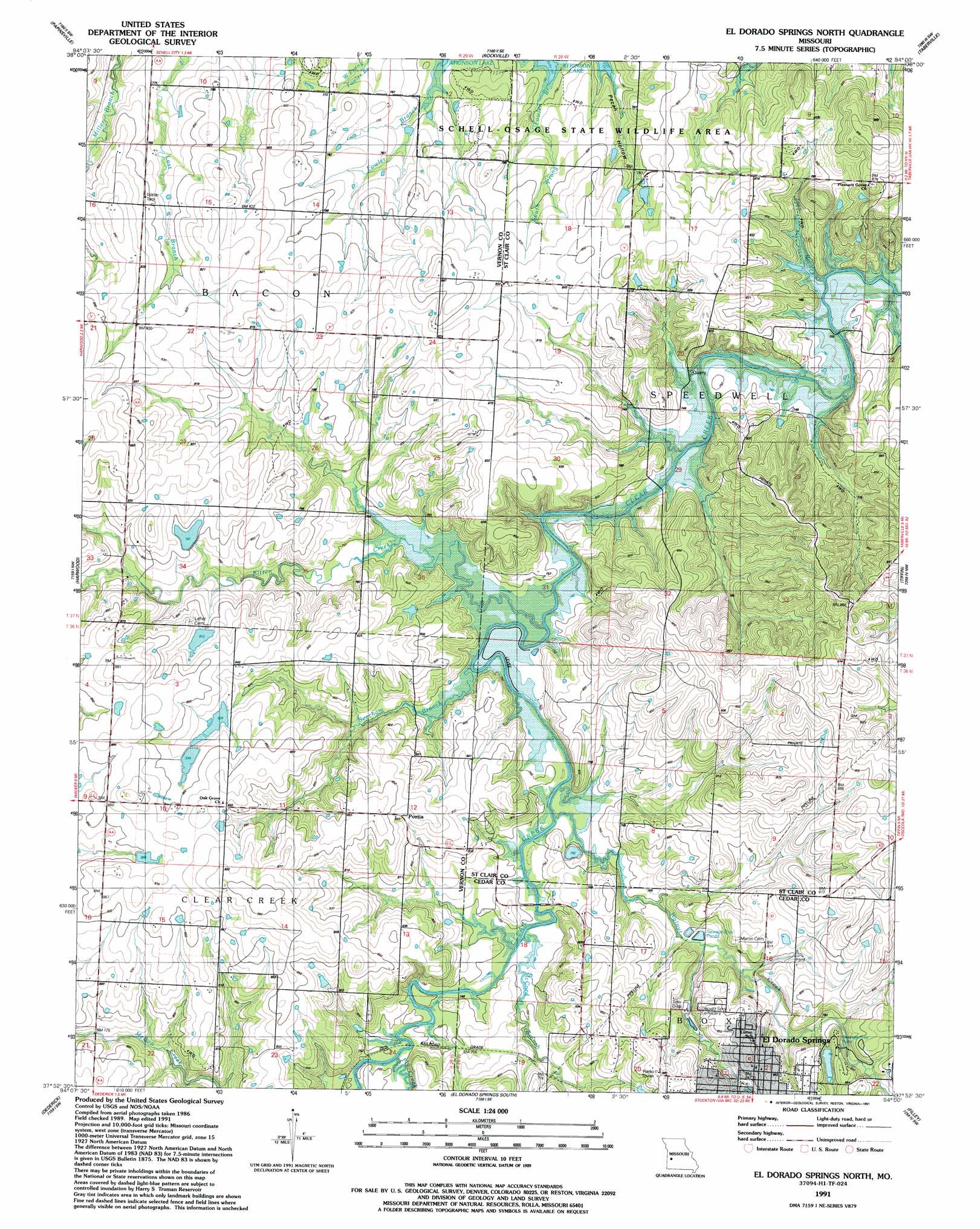
USGS Topo Quad 37094h1 - 1:24,000 scale
| Topo Map Name: | Eldorado Springs North |
| USGS Topo Quad ID: | 37094h1 |
| Print Size: | ca. 21 1/4" wide x 27" high |
| Southeast Coordinates: | 37.875° N latitude / 94° W longitude |
| Map Center Coordinates: | 37.9375° N latitude / 94.0625° W longitude |
| U.S. State: | MO |
| Filename: | o37094h1.jpg |
| Download Map JPG Image: | Eldorado Springs North topo map 1:24,000 scale |
| Map Type: | Topographic |
| Topo Series: | 7.5´ |
| Map Scale: | 1:24,000 |
| Source of Map Images: | United States Geological Survey (USGS) |
| Alternate Map Versions: |
Eldorado Springs North MO 1939, updated 1959 Download PDF Buy paper map Eldorado Springs North MO 1939, updated 1962 Download PDF Buy paper map Eldorado Springs North MO 1941 Download PDF Buy paper map El Dorado Springs North MO 1991, updated 1991 Download PDF Buy paper map El Dorado Springs North MO 2011 Download PDF Buy paper map El Dorado Springs North MO 2015 Download PDF Buy paper map |
1:24,000 Topo Quads surrounding Eldorado Springs North
Butler & Vic |
Pleasant Gap |
Appleton City |
Monegaw Springs Nw |
Ohio |
Rich Hill |
Papinsville |
Rockville |
Taberville |
Monegaw Springs |
Horton |
Harwood |
Eldorado Springs North |
Tiffin |
Roscoe |
Nevada |
Dederick |
Eldorado Springs South |
Filley |
Caplinger Mills |
Sheldon |
Bellamy |
Montevallo |
Wagoner |
Stockton |
> Back to 37094e1 at 1:100,000 scale
> Back to 37094a1 at 1:250,000 scale
> Back to U.S. Topo Maps home
Eldorado Springs North topo map: Gazetteer
Eldorado Springs North: Dams
Beard Lake Dam elevation 242m 793′Floyd Hines Dam elevation 260m 853′
Hines Lake Section 10 Dam elevation 256m 839′
Hines Section 3 North Dam elevation 246m 807′
Hines Section 3 South Lake Dam elevation 252m 826′
Eldorado Springs North: Parks
El Dorado Springs City Park elevation 255m 836′Eldorado Springs North: Populated Places
Donia elevation 257m 843′El Dorado Springs elevation 259m 849′
Portia elevation 254m 833′
Eldorado Springs North: Post Offices
Donia Post Office elevation 257m 843′Eldorado Springs North: Reservoirs
Floyd Hines Lake elevation 256m 839′Floyd Hines Lake elevation 260m 853′
Eldorado Springs North: Streams
Beecham Branch elevation 222m 728′Fly Creek elevation 223m 731′
Joes Branch elevation 218m 715′
Kitten Creek elevation 222m 728′
McCord Branch elevation 222m 728′
Walnut Creek elevation 222m 728′
Eldorado Springs North digital topo map on disk
Buy this Eldorado Springs North topo map showing relief, roads, GPS coordinates and other geographical features, as a high-resolution digital map file on DVD: