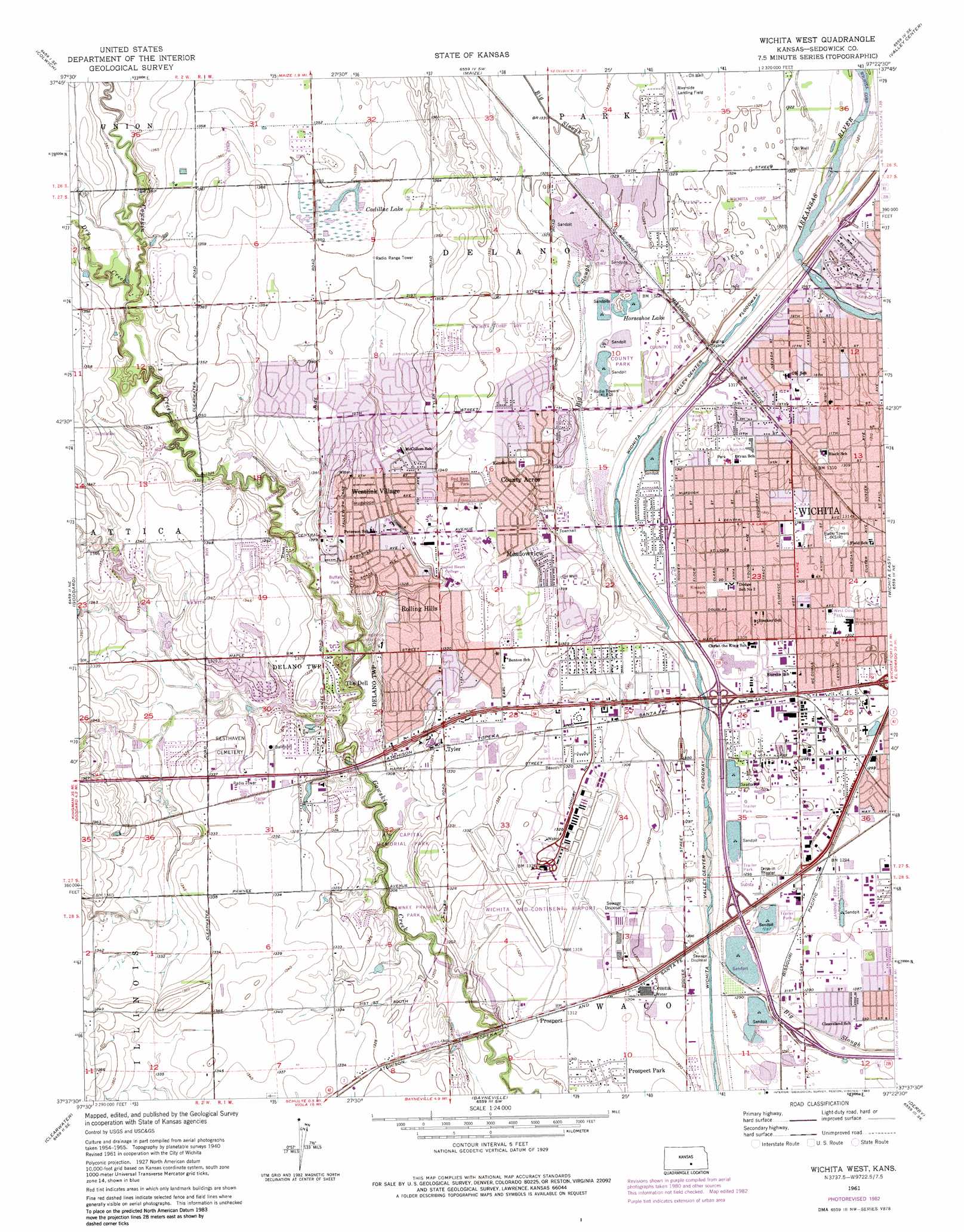
Wichita West Topo Map Kansas
To zoom in, hover over the map of Wichita West
USGS Topo Quad 37097f4 - 1:24,000 scale
| Topo Map Name: | Wichita West |
| USGS Topo Quad ID: | 37097f4 |
| Print Size: | ca. 21 1/4" wide x 27" high |
| Southeast Coordinates: | 37.625° N latitude / 97.375° W longitude |
| Map Center Coordinates: | 37.6875° N latitude / 97.4375° W longitude |
| U.S. State: | KS |
| Filename: | o37097f4.jpg |
| Download Map JPG Image: | Wichita West topo map 1:24,000 scale |
| Map Type: | Topographic |
| Topo Series: | 7.5´ |
| Map Scale: | 1:24,000 |
| Source of Map Images: | United States Geological Survey (USGS) |
| Alternate Map Versions: |
Wichita West KS 1956, updated 1957 Download PDF Buy paper map Wichita West KS 1961, updated 1961 Download PDF Buy paper map Wichita West KS 1961, updated 1971 Download PDF Buy paper map Wichita West KS 1961, updated 1976 Download PDF Buy paper map Wichita West KS 1961, updated 1983 Download PDF Buy paper map Wichita West KS 2010 Download PDF Buy paper map Wichita West KS 2012 Download PDF Buy paper map Wichita West KS 2015 Download PDF Buy paper map |
1:24,000 Topo Quads surrounding Wichita West
Patterson |
Bentley |
Sedgwick |
Sedgwick Ne |
Whitewater |
Mount Hope |
Colwich |
Maize |
Valley Center |
Greenwich |
Garden Plain |
Goddard |
Wichita West |
Wichita East |
Andover |
Lake Afton |
Clearwater |
Bayneville |
Derby |
Rose Hill |
Conway Springs |
Millerton |
Zyba |
Belle Plaine |
Mulvane |
> Back to 37097e1 at 1:100,000 scale
> Back to 37096a1 at 1:250,000 scale
> Back to U.S. Topo Maps home
Wichita West topo map: Gazetteer
Wichita West: Airports
Kake Helistop elevation 403m 1322′Riverside Landing Field elevation 406m 1332′
Triangle Airport elevation 393m 1289′
Westport Airport elevation 394m 1292′
Westport Landing Field elevation 394m 1292′
Wichita Mid-Continent Airport elevation 406m 1332′
Wichita West: Lakes
Horseshoe Lake elevation 402m 1318′Wichita West: Parks
Air Capital Memorial Park elevation 400m 1312′Brown Thrush Park elevation 408m 1338′
Buffalo Park elevation 403m 1322′
Kiwanis Park elevation 399m 1309′
Pawnee Prairie Park elevation 400m 1312′
Red Barn Park elevation 410m 1345′
Swanson Tract Park elevation 400m 1312′
Sycamore Park elevation 401m 1315′
West Douglas Park elevation 398m 1305′
Wichita West: Populated Places
Cessna elevation 397m 1302′County Acres elevation 409m 1341′
Fishin Mobile Home Park elevation 395m 1295′
Lakeside Manufactured Home Community elevation 394m 1292′
Meadowview elevation 407m 1335′
Orchard Park Mobile Home Park elevation 399m 1309′
Powell Mobile Home Park elevation 399m 1309′
Prospect elevation 401m 1315′
Prospect Park elevation 399m 1309′
Reds Mobile Home Park elevation 399m 1309′
Rolling Hills elevation 403m 1322′
Sites Mobile Home Park elevation 402m 1318′
Sleepy Hollow Mobile Home Park elevation 395m 1295′
The Dell elevation 403m 1322′
Tyler elevation 404m 1325′
Westlink Village elevation 406m 1332′
Wichita West: Post Offices
Wichita Post Office elevation 402m 1318′Wichita West: Reservoirs
Cadillac Lake elevation 412m 1351′Wichita West: Streams
Big Slough elevation 395m 1295′Dry Creek elevation 407m 1335′
Wichita West digital topo map on disk
Buy this Wichita West topo map showing relief, roads, GPS coordinates and other geographical features, as a high-resolution digital map file on DVD: