Wilburton Topo Map Kansas
To zoom in, hover over the map of Wilburton
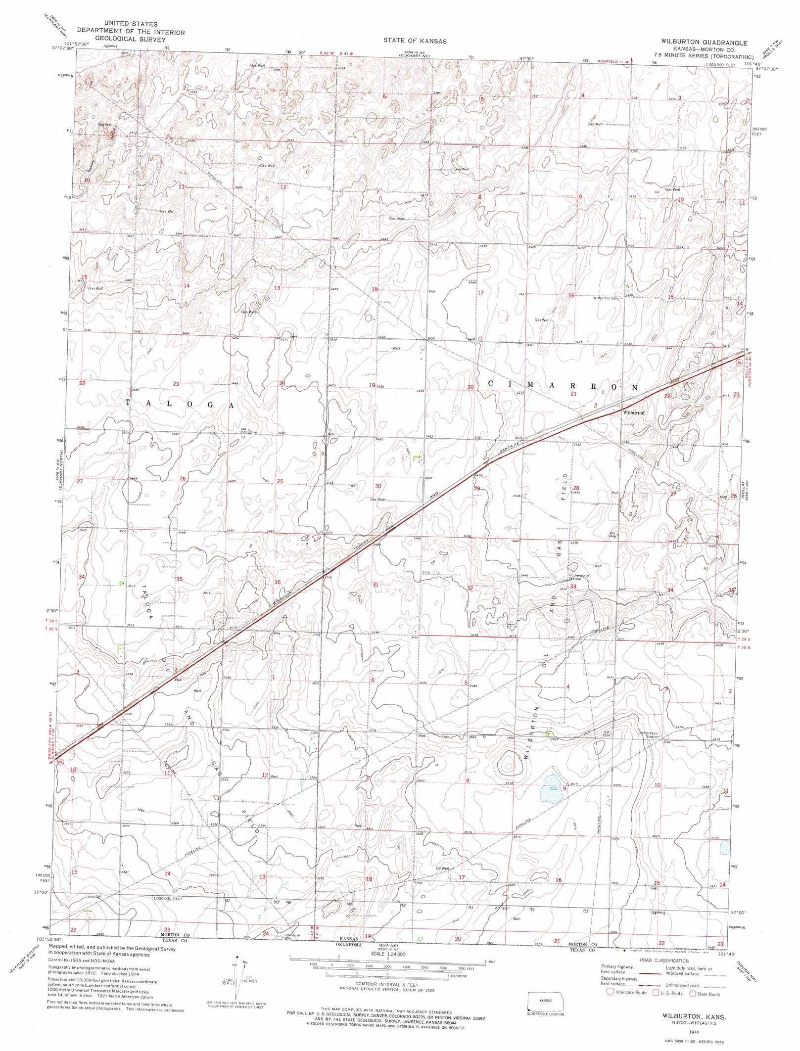
USGS Topo Quad 37101a7 - 1:24,000 scale
| Topo Map Name: | Wilburton |
| USGS Topo Quad ID: | 37101a7 |
| Print Size: | ca. 21 1/4" wide x 27" high |
| Southeast Coordinates: | 37° N latitude / 101.75° W longitude |
| Map Center Coordinates: | 37.0625° N latitude / 101.8125° W longitude |
| U.S. State: | KS |
| Filename: | o37101a7.jpg |
| Download Map JPG Image: | Wilburton topo map 1:24,000 scale |
| Map Type: | Topographic |
| Topo Series: | 7.5´ |
| Map Scale: | 1:24,000 |
| Source of Map Images: | United States Geological Survey (USGS) |
| Alternate Map Versions: |
Wilburton KS 1974, updated 1975 Download PDF Buy paper map Wilburton KS 2011 Download PDF Buy paper map Wilburton KS 2012 Download PDF Buy paper map Wilburton KS 2015 Download PDF Buy paper map |
| FStopo: | US Forest Service topo Wilburton is available: Download FStopo PDF Download FStopo TIF |
1:24,000 Topo Quads surrounding Wilburton
Stonington Se |
Richfield Sw |
Richfield |
Shore Airport Sw |
Shore Airport Se |
Midway Ne |
Elkhart Nw |
Elkhart Ne |
Rolla Nw |
Rolla Ne |
Midway Se |
Elkhart North |
Wilburton |
Rolla |
Rolla Se |
Sturgis |
Elkhart South |
Eva Ne |
Hough Nw |
Hough Ne |
Hopkins |
Eva |
Eva Se |
Hough Sw |
Hough |
> Back to 37101a1 at 1:100,000 scale
> Back to 37100a1 at 1:250,000 scale
> Back to U.S. Topo Maps home
Wilburton topo map: Gazetteer
Wilburton: Flats
Artesian Pasture elevation 1038m 3405′Coen Pasture elevation 1043m 3421′
Pasture Number Fortyeight elevation 1052m 3451′
Pasture Number Fortynine elevation 1043m 3421′
Pasture Number Fortyone elevation 1062m 3484′
Pasture Number Fortythree elevation 1058m 3471′
Pasture Number Thirtyseven elevation 1060m 3477′
Pasture Number Thirtysix elevation 1060m 3477′
Pasture Number Thirtythree elevation 1084m 3556′
Sandhills Pasture elevation 1028m 3372′
Wilburton: Oilfields
Taloga Oil and Gas Field elevation 1083m 3553′Wilburton Oil and Gas Field elevation 1058m 3471′
Wilburton: Populated Places
Wilburton elevation 1045m 3428′Wilburton digital topo map on disk
Buy this Wilburton topo map showing relief, roads, GPS coordinates and other geographical features, as a high-resolution digital map file on DVD: