Miners Peak Topo Map Colorado
To zoom in, hover over the map of Miners Peak
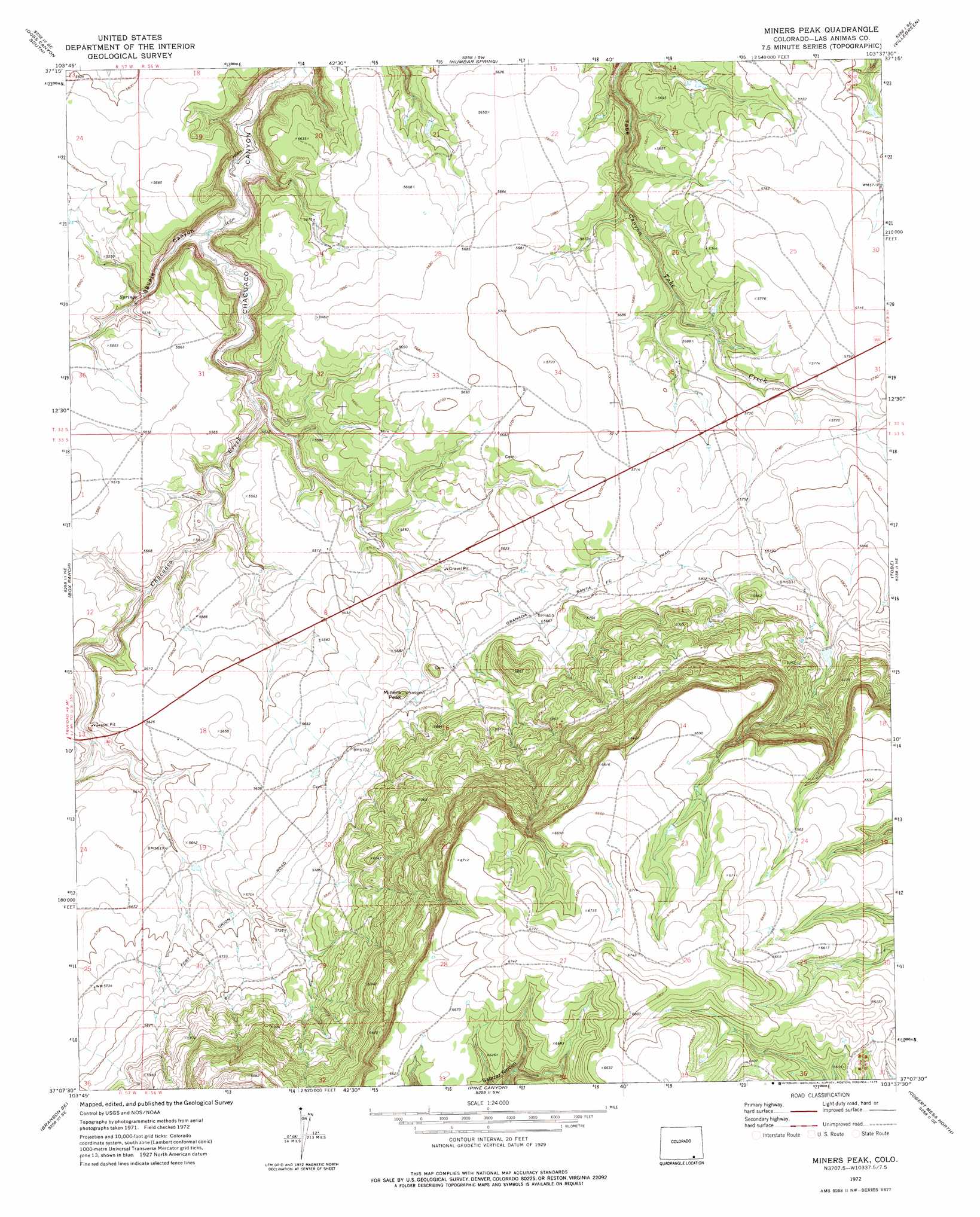
USGS Topo Quad 37103b6 - 1:24,000 scale
| Topo Map Name: | Miners Peak |
| USGS Topo Quad ID: | 37103b6 |
| Print Size: | ca. 21 1/4" wide x 27" high |
| Southeast Coordinates: | 37.125° N latitude / 103.625° W longitude |
| Map Center Coordinates: | 37.1875° N latitude / 103.6875° W longitude |
| U.S. State: | CO |
| Filename: | o37103b6.jpg |
| Download Map JPG Image: | Miners Peak topo map 1:24,000 scale |
| Map Type: | Topographic |
| Topo Series: | 7.5´ |
| Map Scale: | 1:24,000 |
| Source of Map Images: | United States Geological Survey (USGS) |
| Alternate Map Versions: |
Miners Peak CO 1972, updated 1975 Download PDF Buy paper map Miners Peak CO 1972, updated 1975 Download PDF Buy paper map Miners Peak CO 1996, updated 2000 Download PDF Buy paper map Miners Peak CO 2011 Download PDF Buy paper map Miners Peak CO 2013 Download PDF Buy paper map Miners Peak CO 2016 Download PDF Buy paper map |
| FStopo: | US Forest Service topo Miners Peak is available: Download FStopo PDF Download FStopo TIF |
1:24,000 Topo Quads surrounding Miners Peak
Rock Crossing |
Doss Canyon North |
Johnson Canyon |
Plum Canyon |
Icehouse Canyon |
Painted Canyon |
Doss Canyon South |
Humbar Spring |
Villegreen |
Cherry Canyon |
Trementina Canyon |
Box Ranch |
Miners Peak |
Tobe |
Dalerose Mesa |
Branson |
Branson Se |
Pine Canyon |
Cobert Mesa North |
Jesus Canyon |
Alps Mesa |
Emery Peak |
Cross L Ranch |
Cobert Mesa South |
Travesser Park |
> Back to 37103a1 at 1:100,000 scale
> Back to 37102a1 at 1:250,000 scale
> Back to U.S. Topo Maps home
Miners Peak topo map: Gazetteer
Miners Peak: Summits
Miners Peak elevation 1738m 5702′Miners Peak: Valleys
Aguaje Canyon elevation 1628m 5341′Salazar Rincon elevation 2018m 6620′
Miners Peak digital topo map on disk
Buy this Miners Peak topo map showing relief, roads, GPS coordinates and other geographical features, as a high-resolution digital map file on DVD: