Corbin Canyon Topo Map Colorado
To zoom in, hover over the map of Corbin Canyon
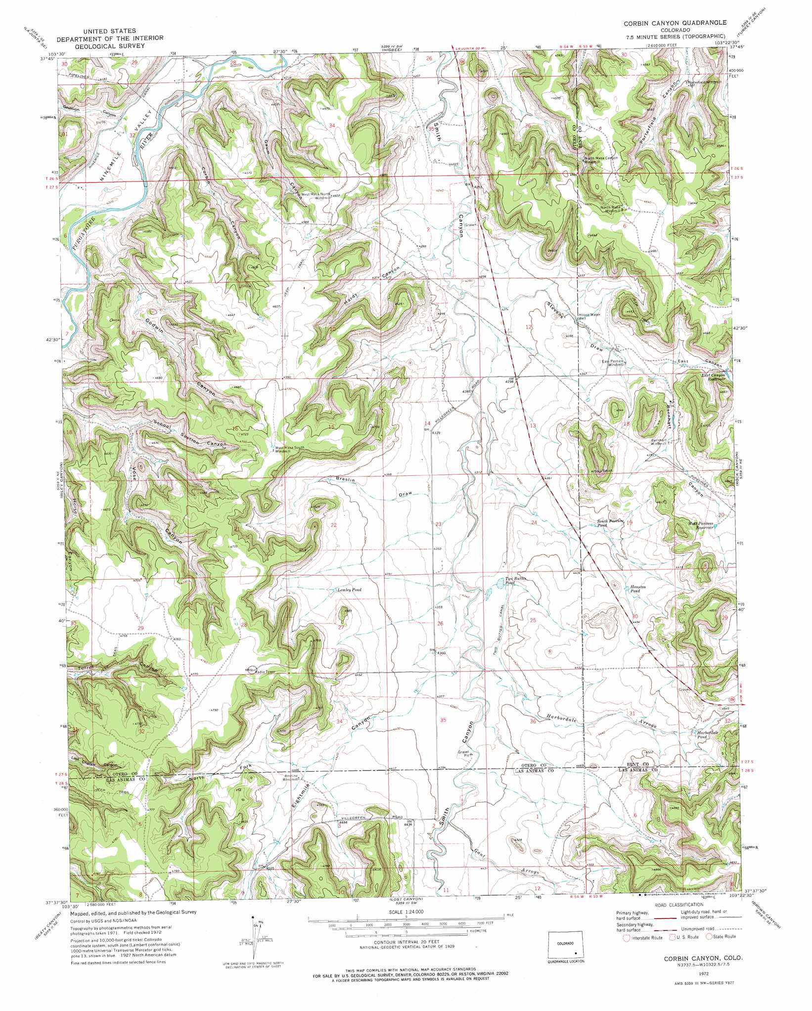
USGS Topo Quad 37103f4 - 1:24,000 scale
| Topo Map Name: | Corbin Canyon |
| USGS Topo Quad ID: | 37103f4 |
| Print Size: | ca. 21 1/4" wide x 27" high |
| Southeast Coordinates: | 37.625° N latitude / 103.375° W longitude |
| Map Center Coordinates: | 37.6875° N latitude / 103.4375° W longitude |
| U.S. State: | CO |
| Filename: | o37103f4.jpg |
| Download Map JPG Image: | Corbin Canyon topo map 1:24,000 scale |
| Map Type: | Topographic |
| Topo Series: | 7.5´ |
| Map Scale: | 1:24,000 |
| Source of Map Images: | United States Geological Survey (USGS) |
| Alternate Map Versions: |
Corbin Canyon CO 1972, updated 1976 Download PDF Buy paper map Corbin Canyon CO 1972, updated 1976 Download PDF Buy paper map Corbin Canyon CO 2010 Download PDF Buy paper map Corbin Canyon CO 2013 Download PDF Buy paper map Corbin Canyon CO 2016 Download PDF Buy paper map |
1:24,000 Topo Quads surrounding Corbin Canyon
Hawley |
La Junta |
Thompson Arroyo |
Hackamore Ranch |
Gilpin |
La Junta Sw |
La Junta Se |
Higbee |
Turkey Canyon |
Toonerville |
Packers Gap |
Riley Canyon |
Corbin Canyon |
Rock Canyon |
Ninaview |
O V Mesa |
Beaty Canyon |
Lost Canyon |
Brown Canyon |
Plug Hat Ranch |
Johnson Canyon |
Plum Canyon |
Icehouse Canyon |
Robbers Roost Canyon |
Buck Canyon |
> Back to 37103e1 at 1:100,000 scale
> Back to 37102a1 at 1:250,000 scale
> Back to U.S. Topo Maps home
Corbin Canyon topo map: Gazetteer
Corbin Canyon: Canals
Two Buttes Canal elevation 1333m 4373′Corbin Canyon: Reservoirs
East Canyon Reservoir elevation 1343m 4406′Harbordale Pond elevation 1366m 4481′
Houston Pond elevation 1351m 4432′
Lemley Pond elevation 1353m 4438′
South Pasture Pond elevation 1330m 4363′
Two Buttes Pond elevation 1326m 4350′
West Parsons Reservoir elevation 1356m 4448′
Corbin Canyon: Streams
Gant Arroyo elevation 1335m 4379′Harbordale Arroyo elevation 1322m 4337′
Corbin Canyon: Valleys
Barnhart Canyon elevation 1326m 4350′Breslin Draw elevation 1312m 4304′
Corbin Canyon elevation 1281m 4202′
East Canyon elevation 1327m 4353′
Eightmile Canyon elevation 1322m 4337′
Gaum Canyon elevation 1278m 4192′
Gaussion Canyon elevation 1286m 4219′
Godwin Canyon elevation 1287m 4222′
Hardy Canyon elevation 1298m 4258′
North Fork Eightmile Canyon elevation 1348m 4422′
School Section Canyon elevation 1322m 4337′
Stevens Draw elevation 1299m 4261′
Corbin Canyon: Wells
House Water Well elevation 1312m 4304′Corbin Canyon digital topo map on disk
Buy this Corbin Canyon topo map showing relief, roads, GPS coordinates and other geographical features, as a high-resolution digital map file on DVD: