Manassa Topo Map Colorado
To zoom in, hover over the map of Manassa
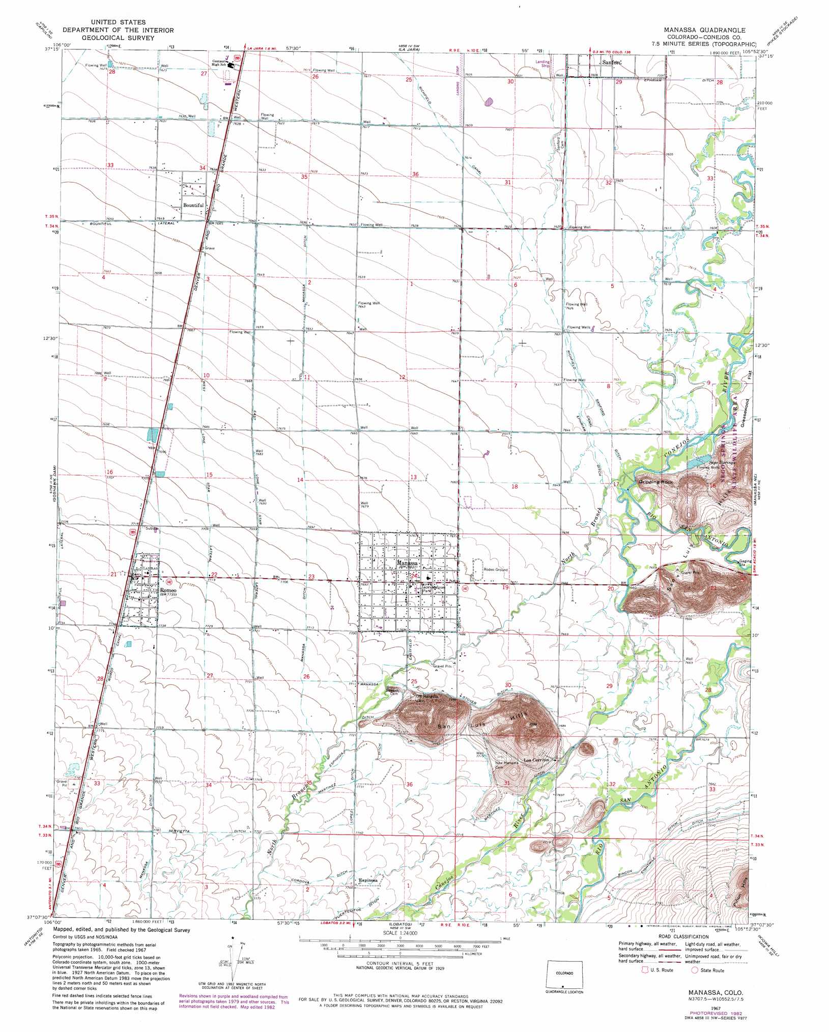
USGS Topo Quad 37105b8 - 1:24,000 scale
| Topo Map Name: | Manassa |
| USGS Topo Quad ID: | 37105b8 |
| Print Size: | ca. 21 1/4" wide x 27" high |
| Southeast Coordinates: | 37.125° N latitude / 105.875° W longitude |
| Map Center Coordinates: | 37.1875° N latitude / 105.9375° W longitude |
| U.S. State: | CO |
| Filename: | o37105b8.jpg |
| Download Map JPG Image: | Manassa topo map 1:24,000 scale |
| Map Type: | Topographic |
| Topo Series: | 7.5´ |
| Map Scale: | 1:24,000 |
| Source of Map Images: | United States Geological Survey (USGS) |
| Alternate Map Versions: |
Manassa CO 1967, updated 1971 Download PDF Buy paper map Manassa CO 1967, updated 1971 Download PDF Buy paper map Manassa CO 1967, updated 1982 Download PDF Buy paper map Manassa CO 2010 Download PDF Buy paper map Manassa CO 2013 Download PDF Buy paper map Manassa CO 2016 Download PDF Buy paper map |
1:24,000 Topo Quads surrounding Manassa
Fulcher Gulch |
Waverly |
Alamosa West |
Alamosa East |
Baldy |
Centro |
Capulin |
La Jara |
Pikes Stockade |
Lasauses |
Vicente Canyon |
Goshawk Dam |
Manassa |
Manassa Ne |
Mesito Reservoir |
Fox Creek |
Antonito |
Lobatos |
Kiowa Hill |
Sky Valley Ranch |
Bighorn Peak |
Los Pinos |
Pinabetoso Peaks |
La Segita Peaks Ne |
Ute Mountain |
> Back to 37105a1 at 1:100,000 scale
> Back to 37104a1 at 1:250,000 scale
> Back to U.S. Topo Maps home
Manassa topo map: Gazetteer
Manassa: Airports
Lama Airport elevation 2319m 7608′Manassa: Canals
Cordova Ditch elevation 2364m 7755′East Lone Star Lateral elevation 2347m 7700′
Eightmile Ditch elevation 2351m 7713′
Ephriam Ditch elevation 2319m 7608′
Espinoza Ditch elevation 2353m 7719′
Lopez Ditch elevation 2359m 7739′
Manassa Eastfield Ditch elevation 2338m 7670′
Martinez Ditch elevation 2353m 7719′
Richfield Canal elevation 2321m 7614′
Rincon Ditch elevation 2348m 7703′
Romeo Canal elevation 2366m 7762′
Servietta Ditch elevation 2377m 7798′
Stover Ditch elevation 2346m 7696′
West Lone Star Lateral elevation 2345m 7693′
Manassa: Parks
Jack Dempsey Park elevation 2344m 7690′Sego Springs State Wildlife Area elevation 2349m 7706′
Manassa: Pillars
Dripping Rock elevation 2348m 7703′Manassa: Populated Places
Bountiful elevation 2330m 7644′Espinosa elevation 2361m 7746′
Los Cerritos elevation 2351m 7713′
Manassa elevation 2344m 7690′
Romeo elevation 2358m 7736′
Manassa: Springs
Sego Springs elevation 2330m 7644′Manassa: Streams
North Branch Conejos River elevation 2328m 7637′Rio San Antonio elevation 2330m 7644′
Manassa digital topo map on disk
Buy this Manassa topo map showing relief, roads, GPS coordinates and other geographical features, as a high-resolution digital map file on DVD: