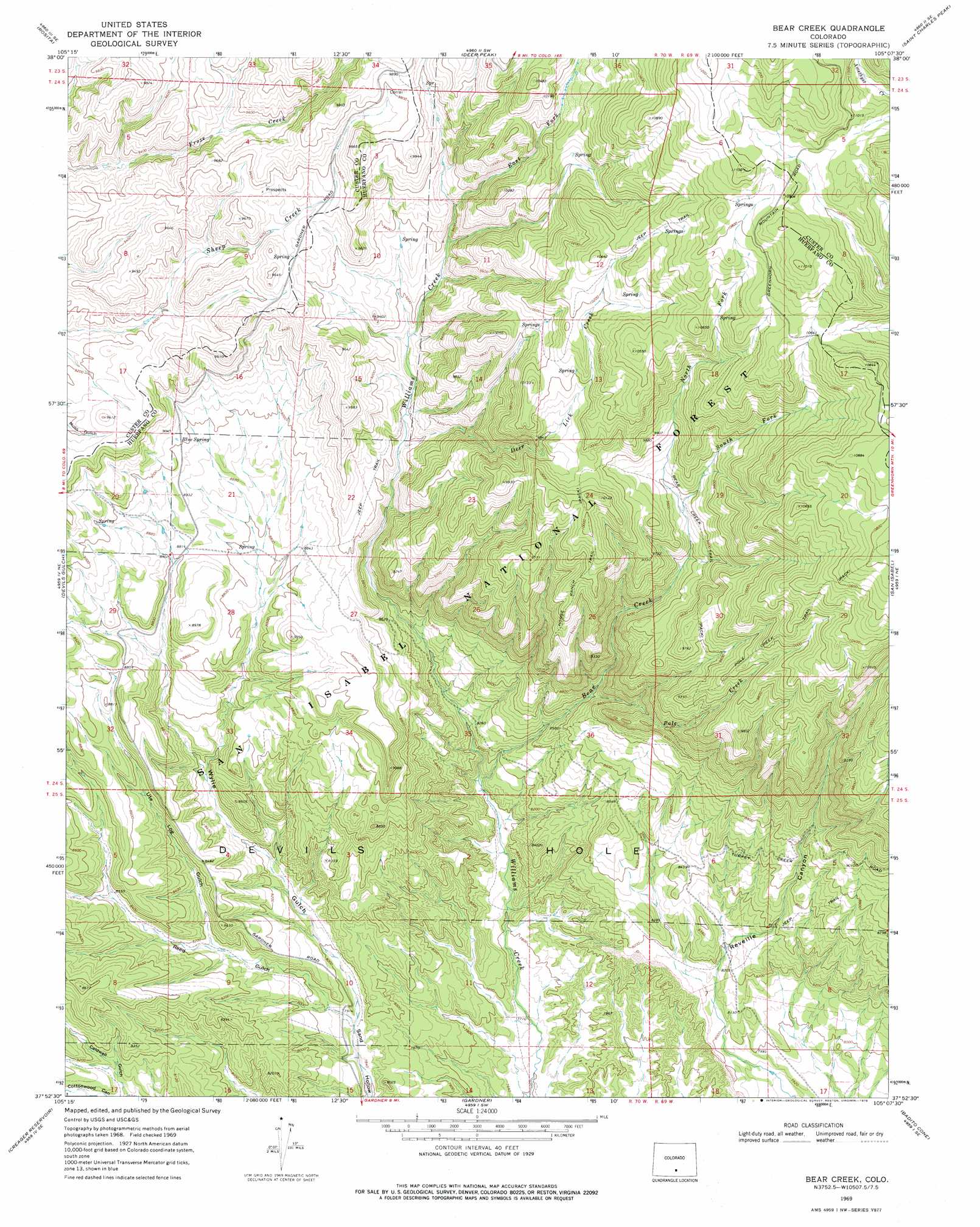
Bear Creek Topo Map Colorado
To zoom in, hover over the map of Bear Creek
USGS Topo Quad 37105h2 - 1:24,000 scale
| Topo Map Name: | Bear Creek |
| USGS Topo Quad ID: | 37105h2 |
| Print Size: | ca. 21 1/4" wide x 27" high |
| Southeast Coordinates: | 37.875° N latitude / 105.125° W longitude |
| Map Center Coordinates: | 37.9375° N latitude / 105.1875° W longitude |
| U.S. State: | CO |
| Filename: | o37105h2.jpg |
| Download Map JPG Image: | Bear Creek topo map 1:24,000 scale |
| Map Type: | Topographic |
| Topo Series: | 7.5´ |
| Map Scale: | 1:24,000 |
| Source of Map Images: | United States Geological Survey (USGS) |
| Alternate Map Versions: |
Bear Creek CO 1969, updated 1973 Download PDF Buy paper map Bear Creek CO 1969, updated 1973 Download PDF Buy paper map Bear Creek CO 1969, updated 1978 Download PDF Buy paper map Bear Creek CO 1994, updated 1998 Download PDF Buy paper map Bear Creek CO 1994, updated 1998 Download PDF Buy paper map Bear Creek CO 2011 Download PDF Buy paper map Bear Creek CO 2013 Download PDF Buy paper map Bear Creek CO 2016 Download PDF Buy paper map |
| FStopo: | US Forest Service topo Bear Creek is available: Download FStopo PDF Download FStopo TIF |
1:24,000 Topo Quads surrounding Bear Creek
Westcliffe |
Mount Tyndall |
Hardscrabble Mountain |
Wetmore |
Owl Canyon |
Aldrich Gulch |
Rosita |
Deer Peak |
Saint Charles Peak |
Beulah |
Beck Mountain |
Devils Gulch |
Bear Creek |
San Isabel |
Rye |
Medano Pass |
Creager Reservoir |
Gardner |
Badito Cone |
Hayden Butte |
Mosca Pass |
Red Wing |
Little Sheep Mountain |
Farisita |
Black Hills |
> Back to 37105e1 at 1:100,000 scale
> Back to 37104a1 at 1:250,000 scale
> Back to U.S. Topo Maps home
Bear Creek topo map: Gazetteer
Bear Creek: Basins
Devils Hole elevation 2416m 7926′Bear Creek: Mines
Buckhorn Mine elevation 2586m 8484′Bear Creek: Springs
Blue Spring elevation 2751m 9025′Bear Creek: Streams
Bear Creek elevation 2444m 8018′Deer Lick Creek elevation 2720m 8923′
East Fork Williams Creek elevation 2868m 9409′
North Fork Bear Creek elevation 2895m 9498′
Pole Creek elevation 2611m 8566′
Ricardo Creek elevation 3261m 10698′
South Fork Bear Creek elevation 2895m 9498′
Bear Creek: Trails
Bear Creek Trail elevation 2926m 9599′Horse Ranch Trail elevation 2956m 9698′
Pole Creek Trail elevation 3107m 10193′
Bear Creek: Valleys
Reed Gulch elevation 2405m 7890′Ute Log Gulch elevation 2487m 8159′
Wylie Gulch elevation 2405m 7890′
Bear Creek digital topo map on disk
Buy this Bear Creek topo map showing relief, roads, GPS coordinates and other geographical features, as a high-resolution digital map file on DVD: