Ludwig Mountain Topo Map Colorado
To zoom in, hover over the map of Ludwig Mountain
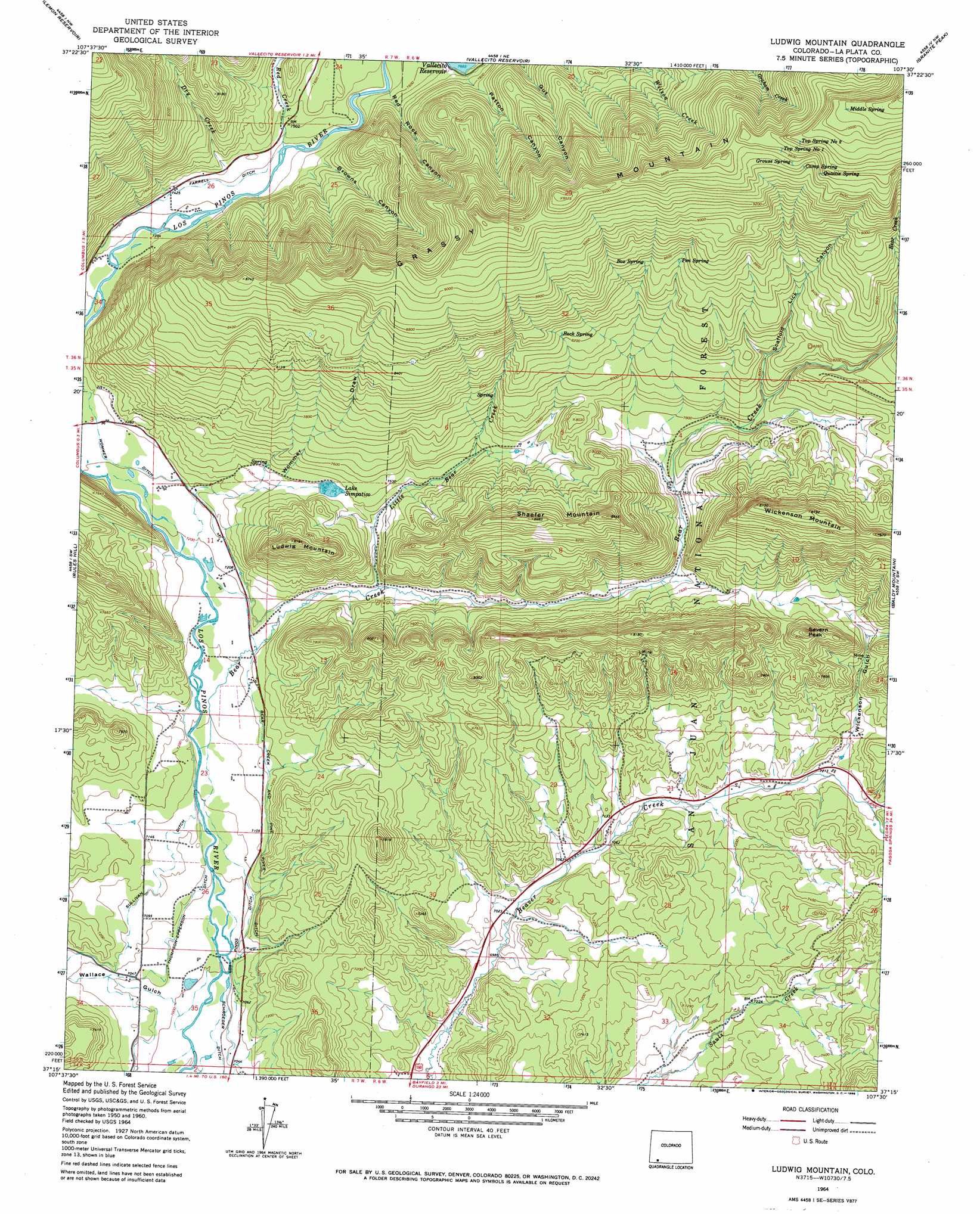
USGS Topo Quad 37107c5 - 1:24,000 scale
| Topo Map Name: | Ludwig Mountain |
| USGS Topo Quad ID: | 37107c5 |
| Print Size: | ca. 21 1/4" wide x 27" high |
| Southeast Coordinates: | 37.25° N latitude / 107.5° W longitude |
| Map Center Coordinates: | 37.3125° N latitude / 107.5625° W longitude |
| U.S. State: | CO |
| Filename: | o37107c5.jpg |
| Download Map JPG Image: | Ludwig Mountain topo map 1:24,000 scale |
| Map Type: | Topographic |
| Topo Series: | 7.5´ |
| Map Scale: | 1:24,000 |
| Source of Map Images: | United States Geological Survey (USGS) |
| Alternate Map Versions: |
Ludwig Mountain CO 1964, updated 1968 Download PDF Buy paper map Ludwig Mountain CO 2011 Download PDF Buy paper map Ludwig Mountain CO 2013 Download PDF Buy paper map Ludwig Mountain CO 2016 Download PDF Buy paper map |
| FStopo: | US Forest Service topo Ludwig Mountain is available: Download FStopo PDF Download FStopo TIF |
1:24,000 Topo Quads surrounding Ludwig Mountain
Electra Lake |
Mountain View Crest |
Columbine Pass |
Emerald Lake |
Granite Lake |
Hermosa |
Lemon Reservoir |
Vallecito Reservoir |
Granite Peak |
Bear Mountain |
Durango East |
Rules Hill |
Ludwig Mountain |
Baldy Mountain |
Devil Mountain |
Loma Linda |
Gem Village |
Bayfield |
Pargin Mountain |
Chimney Rock |
Bondad Hill |
Ignacio |
Tiffany |
Allison |
Carracas |
> Back to 37107a1 at 1:100,000 scale
> Back to 37106a1 at 1:250,000 scale
> Back to U.S. Topo Maps home
Ludwig Mountain topo map: Gazetteer
Ludwig Mountain: Canals
Bear Creek and Pine River Ditch elevation 2184m 7165′Farrell Ditch elevation 2265m 7431′
Los Pinos Ditch elevation 2149m 7050′
Womer Ditch elevation 2209m 7247′
Ludwig Mountain: Dams
Wommer Number 1 Dam elevation 2271m 7450′Ludwig Mountain: Mines
Excelsior Mine elevation 2293m 7522′Palmer Mine elevation 2337m 7667′
Pine River Mine elevation 2190m 7185′
Ludwig Mountain: Reservoirs
Lake Simpatico elevation 2270m 7447′Wommer Reservoir Number 1 elevation 2271m 7450′
Ludwig Mountain: Springs
Box Spring elevation 2603m 8540′Camp Spring elevation 2882m 9455′
Grouse Spring elevation 2913m 9557′
Middle Spring elevation 3075m 10088′
Pen Spring elevation 2600m 8530′
Rock Spring elevation 2523m 8277′
Top Spring Number 1 elevation 2941m 9648′
Top Spring Number 2 elevation 2990m 9809′
Ludwig Mountain: Streams
Bear Creek elevation 2166m 7106′Dry Creek elevation 2288m 7506′
Little Bear Creek elevation 2219m 7280′
Red Creek elevation 2266m 7434′
Ludwig Mountain: Summits
Ludwig Mountain elevation 2496m 8188′Severn Peak elevation 2465m 8087′
Shaefer Mountain elevation 2625m 8612′
Wickenson Mountain elevation 2679m 8789′
Ludwig Mountain: Valleys
Browns Canyon elevation 2293m 7522′Patton Canyon elevation 2343m 7687′
Red Rock Canyon elevation 2296m 7532′
Scaffold Lick Canyon elevation 2394m 7854′
Wallace Gulch elevation 2132m 6994′
Wickenson Gulch elevation 2209m 7247′
Wommer Draw elevation 2212m 7257′
Ludwig Mountain digital topo map on disk
Buy this Ludwig Mountain topo map showing relief, roads, GPS coordinates and other geographical features, as a high-resolution digital map file on DVD: