Bear Mountain Topo Map Colorado
To zoom in, hover over the map of Bear Mountain
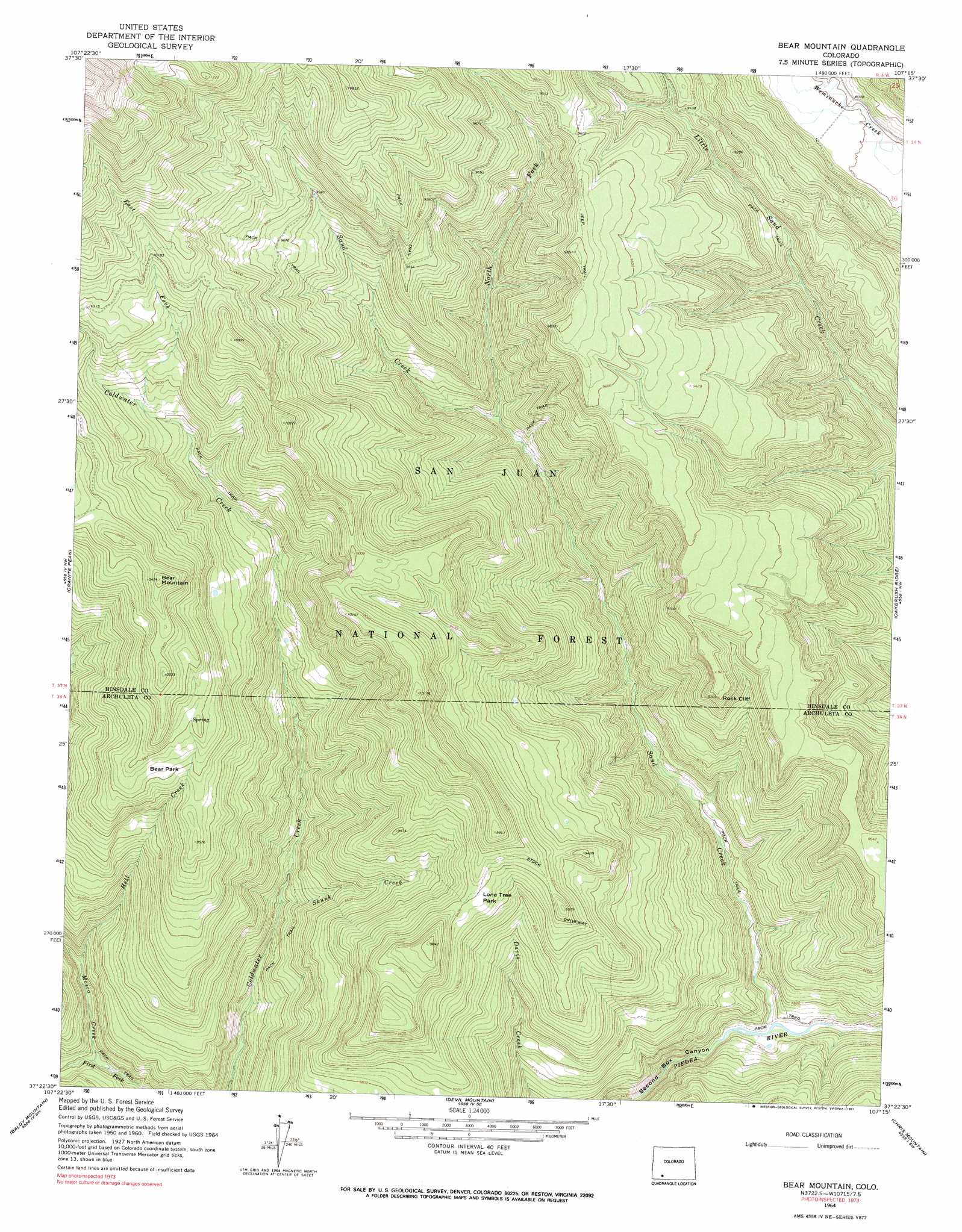
USGS Topo Quad 37107d3 - 1:24,000 scale
| Topo Map Name: | Bear Mountain |
| USGS Topo Quad ID: | 37107d3 |
| Print Size: | ca. 21 1/4" wide x 27" high |
| Southeast Coordinates: | 37.375° N latitude / 107.25° W longitude |
| Map Center Coordinates: | 37.4375° N latitude / 107.3125° W longitude |
| U.S. State: | CO |
| Filename: | o37107d3.jpg |
| Download Map JPG Image: | Bear Mountain topo map 1:24,000 scale |
| Map Type: | Topographic |
| Topo Series: | 7.5´ |
| Map Scale: | 1:24,000 |
| Source of Map Images: | United States Geological Survey (USGS) |
| Alternate Map Versions: |
Bear Mountain CO 1964, updated 1967 Download PDF Buy paper map Bear Mountain CO 1964, updated 1967 Download PDF Buy paper map Bear Mountain CO 1964, updated 1991 Download PDF Buy paper map Bear Mountain CO 2011 Download PDF Buy paper map Bear Mountain CO 2013 Download PDF Buy paper map Bear Mountain CO 2016 Download PDF Buy paper map |
| FStopo: | US Forest Service topo Bear Mountain is available: Download FStopo PDF Download FStopo TIF |
1:24,000 Topo Quads surrounding Bear Mountain
Storm King Peak |
Rio Grande Pyramid |
Weminuche Pass |
Little Squaw Creek |
Workman Creek |
Columbine Pass |
Emerald Lake |
Granite Lake |
Cimarrona Peak |
Palomino Mountain |
Vallecito Reservoir |
Granite Peak |
Bear Mountain |
Oakbrush Ridge |
Pagosa Peak |
Ludwig Mountain |
Baldy Mountain |
Devil Mountain |
Chris Mountain |
Pagosa Springs |
Bayfield |
Pargin Mountain |
Chimney Rock |
Lonetree Canyon |
Oakbrush Hill |
> Back to 37107a1 at 1:100,000 scale
> Back to 37106a1 at 1:250,000 scale
> Back to U.S. Topo Maps home
Bear Mountain topo map: Gazetteer
Bear Mountain: Cliffs
Rock Cliff elevation 2809m 9215′Bear Mountain: Flats
Bear Park elevation 2937m 9635′Lone Tree Park elevation 2864m 9396′
Bear Mountain: Streams
East Fork Coldwater Creek elevation 2878m 9442′Hell Creek elevation 2360m 7742′
Mosca Creek elevation 2294m 7526′
North Fork Sand Creek elevation 2528m 8293′
Sand Creek elevation 2226m 7303′
Skunk Creek elevation 2421m 7942′
West Fork Coldwater Creek elevation 3040m 9973′
Bear Mountain: Summits
Bear Mountain elevation 3189m 10462′Bear Mountain digital topo map on disk
Buy this Bear Mountain topo map showing relief, roads, GPS coordinates and other geographical features, as a high-resolution digital map file on DVD: