Mountain View Crest Topo Map Colorado
To zoom in, hover over the map of Mountain View Crest
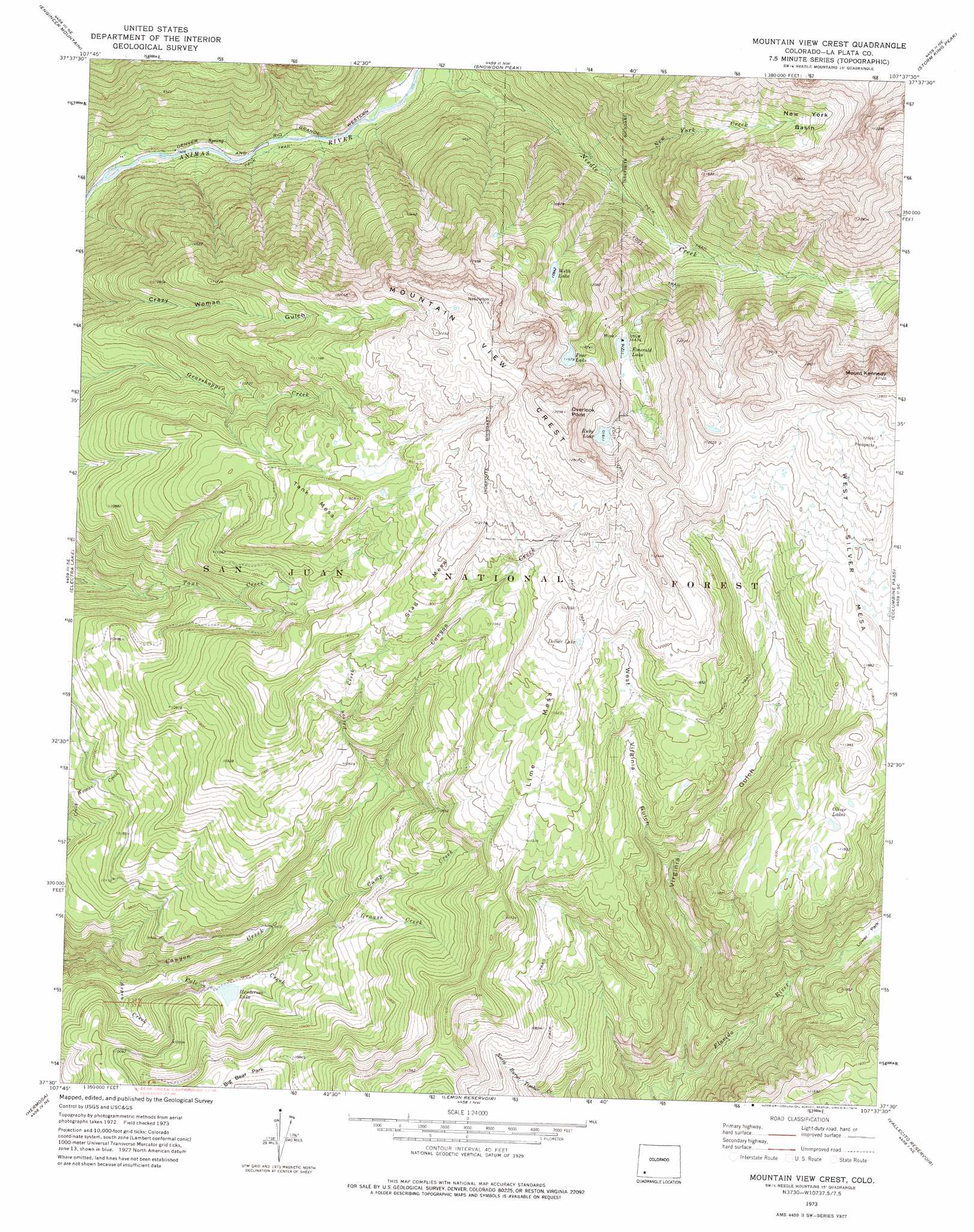
USGS Topo Quad 37107e6 - 1:24,000 scale
| Topo Map Name: | Mountain View Crest |
| USGS Topo Quad ID: | 37107e6 |
| Print Size: | ca. 21 1/4" wide x 27" high |
| Southeast Coordinates: | 37.5° N latitude / 107.625° W longitude |
| Map Center Coordinates: | 37.5625° N latitude / 107.6875° W longitude |
| U.S. State: | CO |
| Filename: | o37107e6.jpg |
| Download Map JPG Image: | Mountain View Crest topo map 1:24,000 scale |
| Map Type: | Topographic |
| Topo Series: | 7.5´ |
| Map Scale: | 1:24,000 |
| Source of Map Images: | United States Geological Survey (USGS) |
| Alternate Map Versions: |
Mountain View Crest CO 1973, updated 1976 Download PDF Buy paper map Mountain View Crest CO 2011 Download PDF Buy paper map Mountain View Crest CO 2013 Download PDF Buy paper map Mountain View Crest CO 2016 Download PDF Buy paper map |
| FStopo: | US Forest Service topo Mountain View Crest is available: Download FStopo PDF Download FStopo TIF |
1:24,000 Topo Quads surrounding Mountain View Crest
Mount Wilson |
Ophir |
Silverton |
Howardsville |
Pole Creek Mountain |
Hermosa Peak |
Engineer Mountain |
Snowdon Peak |
Storm King Peak |
Rio Grande Pyramid |
Elk Creek |
Electra Lake |
Mountain View Crest |
Columbine Pass |
Emerald Lake |
Monument Hill |
Hermosa |
Lemon Reservoir |
Vallecito Reservoir |
Granite Peak |
Durango West |
Durango East |
Rules Hill |
Ludwig Mountain |
Baldy Mountain |
> Back to 37107e1 at 1:100,000 scale
> Back to 37106a1 at 1:250,000 scale
> Back to U.S. Topo Maps home
Mountain View Crest topo map: Gazetteer
Mountain View Crest: Basins
New York Basin elevation 3458m 11345′Mountain View Crest: Cliffs
Overlook Point elevation 3956m 12979′Mountain View Crest: Dams
Henderson Lake Dam elevation 3027m 9931′Mountain View Crest: Flats
Big Bear Park elevation 3245m 10646′Mountain View Crest: Lakes
Dollar Lake elevation 3620m 11876′Emerald Lake elevation 3434m 11266′
Oliver Lakes elevation 3469m 11381′
Pear Lake elevation 3690m 12106′
Ruby Lake elevation 3628m 11902′
Webb Lake elevation 3336m 10944′
Mountain View Crest: Mines
Brooklyn Mine elevation 3008m 9868′Homestake Tunnel Mine elevation 3008m 9868′
Mastodon Mine elevation 3008m 9868′
Slipper Tunnel Mine elevation 3378m 11082′
Mountain View Crest: Reservoirs
Henderson Lake elevation 3027m 9931′Mountain View Crest: Ridges
Mountain View Crest elevation 3837m 12588′Mountain View Crest: Streams
Aspen Creek elevation 2756m 9041′Camp Creek elevation 2939m 9642′
Grouse Creek elevation 2993m 9819′
New York Creek elevation 2789m 9150′
Poison Creek elevation 3118m 10229′
Pole Creek elevation 2813m 9229′
Mountain View Crest: Summits
Lime Mesa elevation 3686m 12093′Mount Kennedy elevation 3962m 12998′
Stag Mesa elevation 3713m 12181′
Tank Mesa elevation 3611m 11847′
West Silver Mesa elevation 3810m 12500′
Mountain View Crest: Valleys
Virginia Gulch elevation 2881m 9452′West Virginia Gulch elevation 3196m 10485′
Mountain View Crest digital topo map on disk
Buy this Mountain View Crest topo map showing relief, roads, GPS coordinates and other geographical features, as a high-resolution digital map file on DVD: