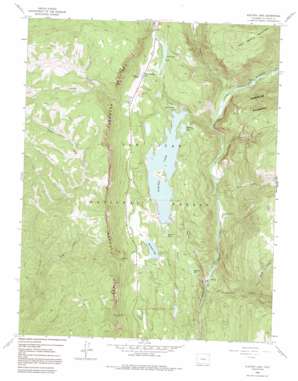
Electra Lake Topo Map Colorado
To zoom in, hover over the map of Electra Lake
USGS Topo Quad 37107e7 - 1:24,000 scale
| Topo Map Name: | Electra Lake |
| USGS Topo Quad ID: | 37107e7 |
| Print Size: | ca. 21 1/4" wide x 27" high |
| Southeast Coordinates: | 37.5° N latitude / 107.75° W longitude |
| Map Center Coordinates: | 37.5625° N latitude / 107.8125° W longitude |
| U.S. State: | CO |
| Filename: | o37107e7.jpg |
| Download Map JPG Image: | Electra Lake topo map 1:24,000 scale |
| Map Type: | Topographic |
| Topo Series: | 7.5´ |
| Map Scale: | 1:24,000 |
| Source of Map Images: | United States Geological Survey (USGS) |
| Alternate Map Versions: |
Electra Lake CO 1960, updated 1963 Download PDF Buy paper map Electra Lake CO 1960, updated 1963 Download PDF Buy paper map Electra Lake CO 1960, updated 1971 Download PDF Buy paper map Electra Lake CO 1960, updated 1971 Download PDF Buy paper map Electra Lake CO 1960, updated 1983 Download PDF Buy paper map Electra Lake CO 1960, updated 1991 Download PDF Buy paper map Electra Lake CO 1960, updated 1991 Download PDF Buy paper map Electra Lake CO 2011 Download PDF Buy paper map Electra Lake CO 2013 Download PDF Buy paper map Electra Lake CO 2016 Download PDF Buy paper map |
| FStopo: | US Forest Service topo Electra Lake is available: Download FStopo PDF Download FStopo TIF |
1:24,000 Topo Quads surrounding Electra Lake
> Back to 37107e1 at 1:100,000 scale
> Back to 37106a1 at 1:250,000 scale
> Back to U.S. Topo Maps home
Electra Lake topo map: Gazetteer
Electra Lake: Cliffs
Hermosa Cliffs elevation 3133m 10278′Electra Lake: Dams
Haviland Lake Dam elevation 2472m 8110′Lake of the Pines Dam elevation 2724m 8937′
Terminal Dam elevation 2559m 8395′
Electra Lake: Lakes
Ignacio Lake elevation 2571m 8435′Papoose Lake elevation 2608m 8556′
Rainbow Lake elevation 2541m 8336′
Electra Lake: Mines
American Minerals Mine elevation 2675m 8776′Silver Star Mine elevation 2470m 8103′
Electra Lake: Populated Places
Cascade elevation 2374m 7788′Tacoma elevation 2224m 7296′
Electra Lake: Reservoirs
Aspaas Lake elevation 2557m 8389′Columbine Lake elevation 2690m 8825′
Electra Lake elevation 2545m 8349′
Forebay Lake elevation 2531m 8303′
Four Base Lake elevation 2528m 8293′
Hatter Pond elevation 2704m 8871′
Haviland Lake elevation 2472m 8110′
Hotter Brothers Lake elevation 2704m 8871′
Lake of the Pines elevation 2724m 8937′
Electra Lake: Streams
Butler Creek elevation 3074m 10085′Canyon Creek elevation 2224m 7296′
Cascade Creek elevation 2343m 7687′
Crazy Woman Creek elevation 2475m 8120′
Elbert Creek elevation 2543m 8343′
Grasshopper Creek elevation 2307m 7568′
Little Cascade Creek elevation 2316m 7598′
Purgatory Creek elevation 2440m 8005′
Tank Creek elevation 2273m 7457′
Electra Lake: Summits
Castle Rock elevation 3169m 10396′Electra Lake: Valleys
Crazy Women Gulch elevation 2432m 7979′Line Canyon elevation 2984m 9790′
Nary Draw elevation 2488m 8162′
Sawmill Canyon elevation 2255m 7398′
Stag Draw elevation 2702m 8864′
Electra Lake digital topo map on disk
Buy this Electra Lake topo map showing relief, roads, GPS coordinates and other geographical features, as a high-resolution digital map file on DVD:


