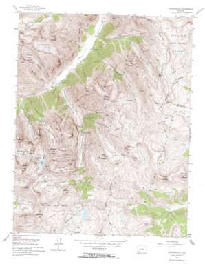
Howardsville Topo Map Colorado
To zoom in, hover over the map of Howardsville
USGS Topo Quad 37107g5 - 1:24,000 scale
| Topo Map Name: | Howardsville |
| USGS Topo Quad ID: | 37107g5 |
| Print Size: | ca. 21 1/4" wide x 27" high |
| Southeast Coordinates: | 37.75° N latitude / 107.5° W longitude |
| Map Center Coordinates: | 37.8125° N latitude / 107.5625° W longitude |
| U.S. State: | CO |
| Filename: | o37107g5.jpg |
| Download Map JPG Image: | Howardsville topo map 1:24,000 scale |
| Map Type: | Topographic |
| Topo Series: | 7.5´ |
| Map Scale: | 1:24,000 |
| Source of Map Images: | United States Geological Survey (USGS) |
| Alternate Map Versions: |
Howardsville CO 1955, updated 1957 Download PDF Buy paper map Howardsville CO 1955, updated 1957 Download PDF Buy paper map Howardsville CO 1955, updated 1963 Download PDF Buy paper map Howardsville CO 1955, updated 1963 Download PDF Buy paper map Howardsville CO 1955, updated 1969 Download PDF Buy paper map Howardsville CO 1955, updated 1969 Download PDF Buy paper map Howardsville CO 2001, updated 2005 Download PDF Buy paper map Howardsville CO 2011 Download PDF Buy paper map Howardsville CO 2013 Download PDF Buy paper map Howardsville CO 2016 Download PDF Buy paper map |
| FStopo: | US Forest Service topo Howardsville is available: Download FStopo PDF Download FStopo TIF |
1:24,000 Topo Quads surrounding Howardsville
> Back to 37107e1 at 1:100,000 scale
> Back to 37106a1 at 1:250,000 scale
> Back to U.S. Topo Maps home
Howardsville topo map: Gazetteer
Howardsville: Basins
Arrastra Basin elevation 3716m 12191′Cataract Basin elevation 3800m 12467′
Dives Basin elevation 3796m 12454′
Hematite Basin elevation 3686m 12093′
Little Giant Basin elevation 3681m 12076′
Royal Tiger Basin elevation 3687m 12096′
Spencer Basin elevation 3757m 12326′
Woodchuck Basin elevation 3754m 12316′
Howardsville: Dams
Highland Mary Dam elevation 3708m 12165′Howardsville: Gaps
Stony Pass elevation 3838m 12591′Howardsville: Lakes
Crystal Lake elevation 3726m 12224′Hematite Lake elevation 3632m 11916′
Highland Mary Lakes elevation 3708m 12165′
Silver Lake elevation 3716m 12191′
Howardsville: Mines
Ayman Mine elevation 3627m 11899′Big Giant Mine elevation 3533m 11591′
Buckeye Mine elevation 3849m 12627′
Buffalo Boy Mine elevation 3854m 12644′
Caledonia Mine elevation 3453m 11328′
Dives Mine elevation 3777m 12391′
Empire-Mascot Mine elevation 3892m 12769′
Esmeralda Mine elevation 3560m 11679′
Galena Mountain Group Mine elevation 3045m 9990′
Gary Owen Mine elevation 3491m 11453′
Gold Lake Mine elevation 3977m 13047′
Gold Nugget Mine elevation 3634m 11922′
Green Mountain Mine elevation 3198m 10492′
Hamlet Mine elevation 3325m 10908′
Highland Mary Mine elevation 3447m 11309′
Iowa Mine elevation 3749m 12299′
Kitti Mack Mine elevation 3561m 11683′
Little Fanney Mine elevation 3545m 11630′
Little Giant Mine elevation 3842m 12604′
Little Maud Mine elevation 3570m 11712′
Little Nation Mine elevation 3106m 10190′
Livingstone Tunnel Mine elevation 3300m 10826′
Maxwell Mine elevation 3096m 10157′
Mayflower Mine elevation 3404m 11167′
Mountaineer Mine elevation 3328m 10918′
Natalie Mine elevation 3685m 12089′
Niegold Group Mine elevation 3797m 12457′
North Star Mine elevation 3845m 12614′
Occidental Tunnel Mine elevation 3556m 11666′
Old Hundred Mine elevation 3785m 12417′
Osceole Mine elevation 3092m 10144′
Philadelphia Mine elevation 3311m 10862′
Pride of the West Mine elevation 3187m 10456′
Ridgeway Mine elevation 3833m 12575′
Royal Tiger Mine elevation 3767m 12358′
Ruby Mine elevation 3195m 10482′
Shenandoah Mine elevation 3719m 12201′
Silver Lake Mine elevation 3865m 12680′
Silver Link Mine elevation 3818m 12526′
Tantallon Mine elevation 3600m 11811′
Terrible Mine elevation 3412m 11194′
Titusville Mine elevation 3974m 13038′
Triby Mine elevation 3551m 11650′
Trilby Group Mine elevation 3551m 11650′
Unity Tunnel elevation 3555m 11663′
Winge Tunnel Mine elevation 3300m 10826′
Howardsville: Populated Places
Howardsville elevation 2971m 9747′Middleton elevation 2985m 9793′
Howardsville: Streams
Cunningham Creek elevation 2941m 9648′Deep Creek elevation 3362m 11030′
Mountaineer Creek elevation 3280m 10761′
Quartzite Creek elevation 3325m 10908′
Royal Tiger Creek elevation 3182m 10439′
Howardsville: Summits
Canby Mountain elevation 4102m 13458′Dome Mountain elevation 4078m 13379′
Galena Mountain elevation 4033m 13231′
Green Mountain elevation 3977m 13047′
Greenhalgh Mountain elevation 4027m 13211′
Hazelton Mountain elevation 3800m 12467′
Kendall Peak elevation 4103m 13461′
King Solomon Mountain elevation 4014m 13169′
Little Giant Peak elevation 4075m 13369′
Macomber Peak elevation 3909m 12824′
Middle Mountain elevation 3953m 12969′
Mount Rhoda elevation 4088m 13412′
Round Mountain elevation 3915m 12844′
Sheep Mountain elevation 4051m 13290′
Sugarloaf elevation 3882m 12736′
Tower Mountain elevation 4119m 13513′
Whitehead Peak elevation 4045m 13270′
Howardsville: Trails
Whitehead Trail elevation 3743m 12280′Howardsville: Valleys
Brendel Gulch elevation 2922m 9586′Cataract Gulch elevation 2951m 9681′
Edith Gulch elevation 2999m 9839′
Hematite Gulch elevation 2940m 9645′
Maggie Gulch elevation 2976m 9763′
Minnie Gulch elevation 3001m 9845′
Otto Gulch elevation 2963m 9721′
Porcupine Gulch elevation 2977m 9767′
Rein Gulch elevation 3572m 11719′
Rocky Gulch elevation 3038m 9967′
Sterling Gulch elevation 3313m 10869′
Stony Gulch elevation 3104m 10183′
Howardsville digital topo map on disk
Buy this Howardsville topo map showing relief, roads, GPS coordinates and other geographical features, as a high-resolution digital map file on DVD:


