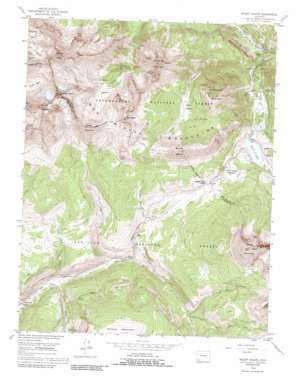
Mount Wilson Topo Map Colorado
To zoom in, hover over the map of Mount Wilson
USGS Topo Quad 37107g8 - 1:24,000 scale
| Topo Map Name: | Mount Wilson |
| USGS Topo Quad ID: | 37107g8 |
| Print Size: | ca. 21 1/4" wide x 27" high |
| Southeast Coordinates: | 37.75° N latitude / 107.875° W longitude |
| Map Center Coordinates: | 37.8125° N latitude / 107.9375° W longitude |
| U.S. State: | CO |
| Filename: | o37107g8.jpg |
| Download Map JPG Image: | Mount Wilson topo map 1:24,000 scale |
| Map Type: | Topographic |
| Topo Series: | 7.5´ |
| Map Scale: | 1:24,000 |
| Source of Map Images: | United States Geological Survey (USGS) |
| Alternate Map Versions: |
Mount Wilson CO 1953, updated 1954 Download PDF Buy paper map Mount Wilson CO 1953, updated 1954 Download PDF Buy paper map Mount Wilson CO 1953, updated 1961 Download PDF Buy paper map Mount Wilson CO 1953, updated 1966 Download PDF Buy paper map Mount Wilson CO 1953, updated 1966 Download PDF Buy paper map Mount Wilson CO 1953, updated 1973 Download PDF Buy paper map Mount Wilson CO 1953, updated 1980 Download PDF Buy paper map Mount Wilson CO 1953, updated 1986 Download PDF Buy paper map Mount Wilson CO 2011 Download PDF Buy paper map Mount Wilson CO 2013 Download PDF Buy paper map Mount Wilson CO 2016 Download PDF Buy paper map |
| FStopo: | US Forest Service topo Mount Wilson is available: Download FStopo PDF Download FStopo TIF |
1:24,000 Topo Quads surrounding Mount Wilson
> Back to 37107e1 at 1:100,000 scale
> Back to 37106a1 at 1:250,000 scale
> Back to U.S. Topo Maps home
Mount Wilson topo map: Gazetteer
Mount Wilson: Basins
Bilk Basin elevation 3433m 11263′Mount Wilson: Dams
Trout Lake Dam elevation 2961m 9714′Mount Wilson: Flats
Lizard Head Meadows elevation 3074m 10085′Wilson Meadows elevation 3222m 10570′
Mount Wilson: Gaps
Lizard Head Pass elevation 3123m 10246′Mount Wilson: Lakes
Owen Lake elevation 3390m 11122′Priest Lakes elevation 2927m 9603′
Mount Wilson: Mines
Atlas Mine elevation 3019m 9904′Butterfly Mine elevation 2930m 9612′
Butterfly Mine elevation 2942m 9652′
Calamine Mine elevation 2881m 9452′
Garibaldi Mine elevation 3003m 9852′
Matterhorn Drifts elevation 3018m 9901′
Moyer and Tucson Mine elevation 2916m 9566′
Old Butterfly Mine elevation 2808m 9212′
Rock of Ages Mine elevation 3920m 12860′
San Bernardo Mine elevation 2993m 9819′
Silver Eagle Mine elevation 3584m 11758′
Silver Hat Mine elevation 3825m 12549′
Silver Pick Mine elevation 3858m 12657′
Special Session Mine elevation 4014m 13169′
Synopsis Mine elevation 3902m 12801′
Mount Wilson: Populated Places
Ames elevation 2658m 8720′Mount Wilson: Reservoirs
Barlow Lake elevation 2975m 9760′Trout Lake elevation 2961m 9714′
Mount Wilson: Streams
Barlow Creek elevation 2837m 9307′Coal Creek elevation 2801m 9189′
Coke Oven Creek elevation 2833m 9294′
Gold Creek elevation 2603m 8540′
Howard Fork elevation 2650m 8694′
Lake Fork elevation 2641m 8664′
Lizard Head Creek elevation 3055m 10022′
Lizard Head Creek elevation 2962m 9717′
North Twin Creek elevation 3080m 10104′
Slate Creek elevation 2893m 9491′
Snow Spur Creek elevation 2927m 9603′
South Twin Creek elevation 3085m 10121′
Wilson Creek elevation 2783m 9130′
Mount Wilson: Summits
Black Face elevation 3682m 12080′Cross Mountain elevation 3871m 12700′
Gladstone Peak elevation 4230m 13877′
Lizard Head elevation 3961m 12995′
Mount Wilson elevation 4324m 14186′
San Bernardo Mountain elevation 3608m 11837′
Sheep Mountain elevation 4016m 13175′
Sunshine Mountain elevation 3943m 12936′
Wilson Peak elevation 4273m 14019′
Mount Wilson: Trails
Cross Mountain Trail elevation 3388m 11115′East Fork Trail elevation 3152m 10341′
Lizard Head Trail elevation 3666m 12027′
Sheep Trail elevation 3311m 10862′
Mount Wilson: Valleys
Groundhog Gulch elevation 2988m 9803′Magpie Gulch elevation 2927m 9603′
Minnie Gulch elevation 2926m 9599′
Rodger Gulch elevation 2962m 9717′
Mount Wilson digital topo map on disk
Buy this Mount Wilson topo map showing relief, roads, GPS coordinates and other geographical features, as a high-resolution digital map file on DVD:


