Mormon Reservoir Topo Map Colorado
To zoom in, hover over the map of Mormon Reservoir
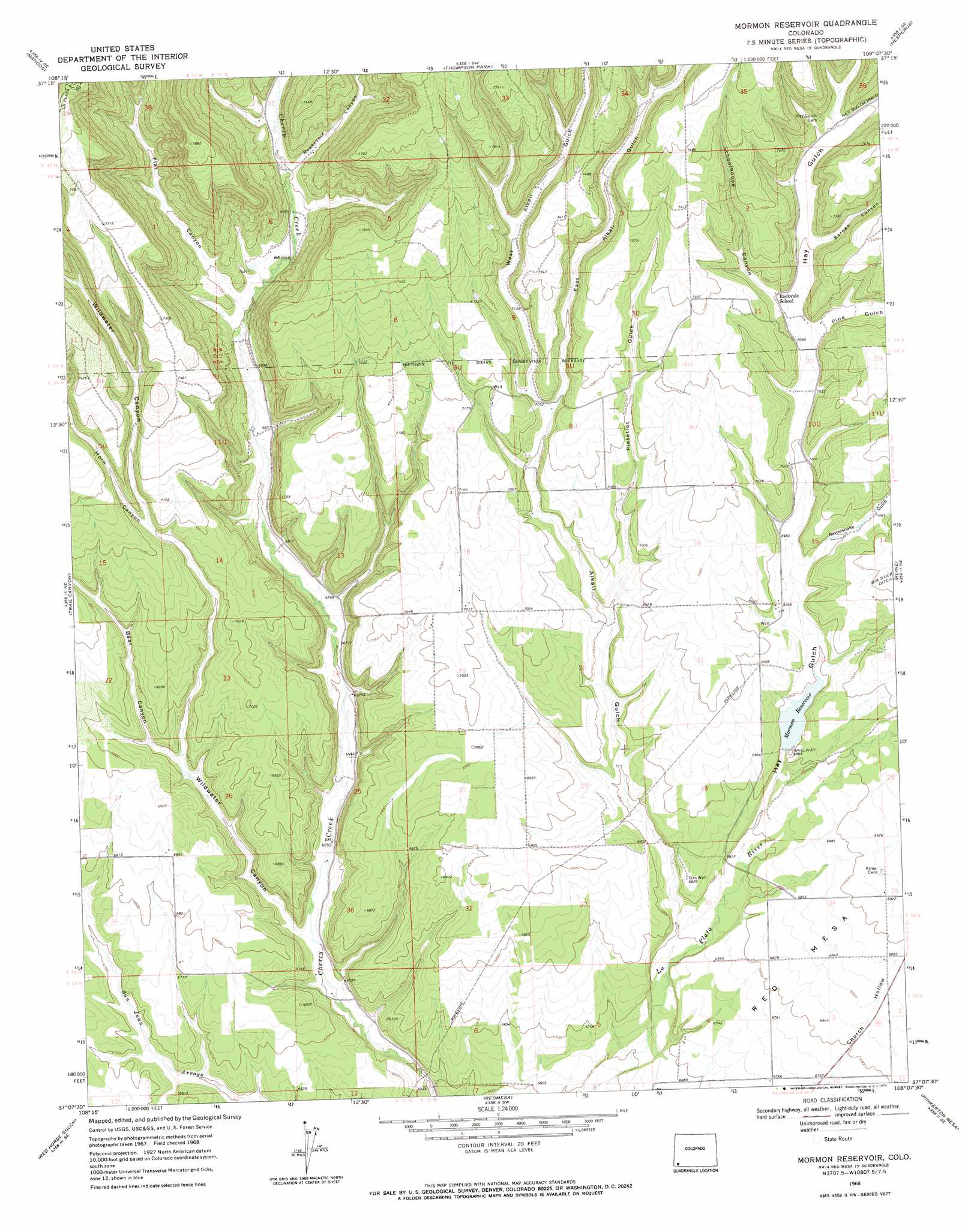
USGS Topo Quad 37108b2 - 1:24,000 scale
| Topo Map Name: | Mormon Reservoir |
| USGS Topo Quad ID: | 37108b2 |
| Print Size: | ca. 21 1/4" wide x 27" high |
| Southeast Coordinates: | 37.125° N latitude / 108.125° W longitude |
| Map Center Coordinates: | 37.1875° N latitude / 108.1875° W longitude |
| U.S. State: | CO |
| Filename: | o37108b2.jpg |
| Download Map JPG Image: | Mormon Reservoir topo map 1:24,000 scale |
| Map Type: | Topographic |
| Topo Series: | 7.5´ |
| Map Scale: | 1:24,000 |
| Source of Map Images: | United States Geological Survey (USGS) |
| Alternate Map Versions: |
Mormon Reservoir CO 1968, updated 1972 Download PDF Buy paper map Mormon Reservoir CO 2010 Download PDF Buy paper map Mormon Reservoir CO 2013 Download PDF Buy paper map Mormon Reservoir CO 2016 Download PDF Buy paper map |
1:24,000 Topo Quads surrounding Mormon Reservoir
Dolores East |
Millwood |
Rampart Hills |
La Plata |
Monument Hill |
Point Lookout |
Mancos |
Thompson Park |
Hesperus |
Durango West |
Moccasin Mesa |
Trail Canyon |
Mormon Reservoir |
Kline |
Basin Mountain |
Greasewood Canyon |
Red Horse Gulch |
Redmesa |
Pinkerton Mesa |
Long Mountain |
Heifer Point |
Purgatory Canyon |
La Plata |
Abode Downs Ranch |
Cedar Hill |
> Back to 37108a1 at 1:100,000 scale
> Back to 37108a1 at 1:250,000 scale
> Back to U.S. Topo Maps home
Mormon Reservoir topo map: Gazetteer
Mormon Reservoir: Canals
Hay Gulch Irrigation Ditch elevation 2199m 7214′Mormon Reservoir: Dams
Red Mesa Ward Dam elevation 2113m 6932′Mormon Reservoir: Mines
Tepoch Mine elevation 2274m 7460′Mormon Reservoir: Reservoirs
Mormon Reservoir elevation 2101m 6893′Red Mesa Ward Reservoir elevation 2113m 6932′
Mormon Reservoir: Valleys
Alkali Gulch elevation 2033m 6669′Barnes Canyon elevation 2170m 7119′
Bear Canyon elevation 2068m 6784′
East Alkali Gulch elevation 2145m 7037′
Flat Canyon elevation 2115m 6938′
Hay Gulch elevation 2073m 6801′
Horn Canyon elevation 2139m 7017′
Pietetlot Gulch elevation 2102m 6896′
Pine Gulch elevation 2153m 7063′
Rattlesnake Gulch elevation 2120m 6955′
Reservoir Canyon elevation 2136m 7007′
Schoolhouse Canyon elevation 2165m 7103′
West Alkali Gulch elevation 2145m 7037′
Wildwater Canyon elevation 2025m 6643′
Mormon Reservoir digital topo map on disk
Buy this Mormon Reservoir topo map showing relief, roads, GPS coordinates and other geographical features, as a high-resolution digital map file on DVD: