Battle Rock Topo Map Colorado
To zoom in, hover over the map of Battle Rock
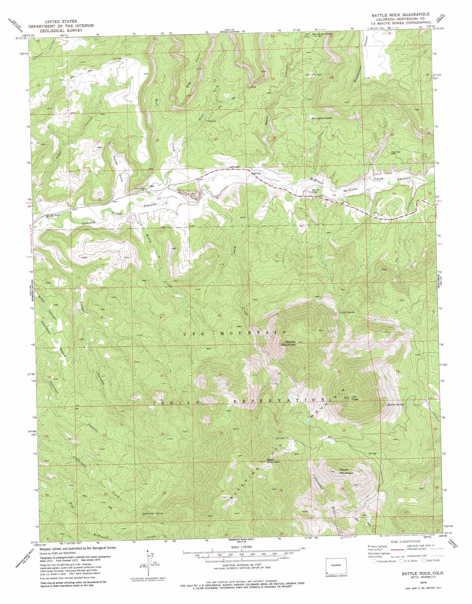
USGS Topo Quad 37108c7 - 1:24,000 scale
| Topo Map Name: | Battle Rock |
| USGS Topo Quad ID: | 37108c7 |
| Print Size: | ca. 21 1/4" wide x 27" high |
| Southeast Coordinates: | 37.25° N latitude / 108.75° W longitude |
| Map Center Coordinates: | 37.3125° N latitude / 108.8125° W longitude |
| U.S. State: | CO |
| Filename: | o37108c7.jpg |
| Download Map JPG Image: | Battle Rock topo map 1:24,000 scale |
| Map Type: | Topographic |
| Topo Series: | 7.5´ |
| Map Scale: | 1:24,000 |
| Source of Map Images: | United States Geological Survey (USGS) |
| Alternate Map Versions: |
Moqui SE CO 1957, updated 1958 Download PDF Buy paper map Battle Rock CO 2010 Download PDF Buy paper map Battle Rock CO 2013 Download PDF Buy paper map Battle Rock CO 2016 Download PDF Buy paper map |
1:24,000 Topo Quads surrounding Battle Rock
Papoose Canyon |
Ruin Canyon |
Pleasant View |
Yellow Jacket |
Trimble Point |
Ruin Point |
Negro Canyon |
Woods Canyon |
Arriola |
Dolores West |
Wickiup Canyon |
Bowdish Canyon |
Battle Rock |
Mud Creek |
Cortez |
Peters Nipple |
Mariano Wash West |
Mariano Wash East |
Towaoc |
Wetherill Mesa |
Aneth Se |
Sentinel Peak Sw |
Sentinel Peak Se |
Tanner Mesa |
Moqui Canyon |
> Back to 37108a1 at 1:100,000 scale
> Back to 37108a1 at 1:250,000 scale
> Back to U.S. Topo Maps home
Battle Rock topo map: Gazetteer
Battle Rock: Cliffs
Goodman Point elevation 2181m 7155′Battle Rock: Mines
Battle Rock Mine elevation 1676m 5498′Cliff House Mine elevation 1676m 5498′
Karla Kay Mine elevation 1791m 5875′
Little Maude Mine elevation 2191m 7188′
Three States Mine elevation 1819m 5967′
Battle Rock: Ridges
Sleeping Ute Mountain elevation 2817m 9242′Battle Rock: Springs
Hanna Spring elevation 2296m 7532′Littlewater Spring elevation 2247m 7372′
Ute Spring elevation 2064m 6771′
Battle Rock: Streams
Berry Creek elevation 1623m 5324′East Fork Rock Creek elevation 1658m 5439′
Pine Creek elevation 1648m 5406′
Rock Creek elevation 1630m 5347′
Ute Creek elevation 1689m 5541′
Battle Rock: Summits
Battle Rock elevation 1668m 5472′Black Mountain elevation 2863m 9393′
Horse Mountain elevation 2769m 9084′
Marble Mountain elevation 2618m 8589′
Ute Peak elevation 3037m 9963′
Battle Rock: Valleys
Finley Canyon elevation 1622m 5321′Porter Cove elevation 1631m 5351′
Sand Canyon elevation 1668m 5472′
Tozer Canyon elevation 1624m 5328′
Battle Rock digital topo map on disk
Buy this Battle Rock topo map showing relief, roads, GPS coordinates and other geographical features, as a high-resolution digital map file on DVD: