Dolores East Topo Map Colorado
To zoom in, hover over the map of Dolores East
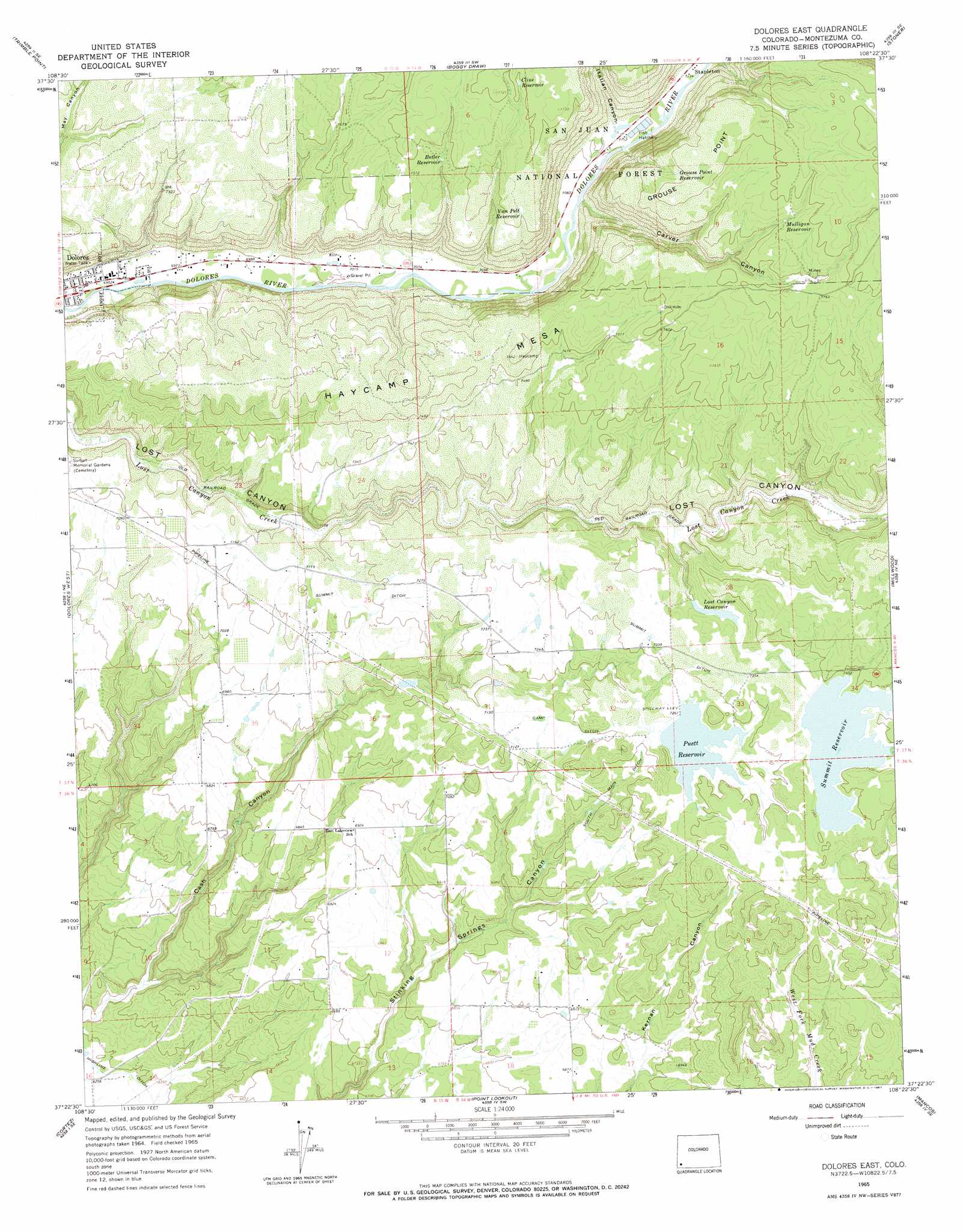
USGS Topo Quad 37108d4 - 1:24,000 scale
| Topo Map Name: | Dolores East |
| USGS Topo Quad ID: | 37108d4 |
| Print Size: | ca. 21 1/4" wide x 27" high |
| Southeast Coordinates: | 37.375° N latitude / 108.375° W longitude |
| Map Center Coordinates: | 37.4375° N latitude / 108.4375° W longitude |
| U.S. State: | CO |
| Filename: | o37108d4.jpg |
| Download Map JPG Image: | Dolores East topo map 1:24,000 scale |
| Map Type: | Topographic |
| Topo Series: | 7.5´ |
| Map Scale: | 1:24,000 |
| Source of Map Images: | United States Geological Survey (USGS) |
| Alternate Map Versions: |
Dolores East CO 1965, updated 1967 Download PDF Buy paper map Dolores East CO 1965, updated 1967 Download PDF Buy paper map Dolores East CO 2011 Download PDF Buy paper map Dolores East CO 2013 Download PDF Buy paper map Dolores East CO 2016 Download PDF Buy paper map |
| FStopo: | US Forest Service topo Dolores East is available: Download FStopo PDF Download FStopo TIF |
1:24,000 Topo Quads surrounding Dolores East
Doe Canyon |
Narraguinnep Mountain |
Willow Spring |
Nipple Mountain |
Clyde Lake |
Yellow Jacket |
Trimble Point |
Boggy Draw |
Stoner |
Wallace Ranch |
Arriola |
Dolores West |
Dolores East |
Millwood |
Rampart Hills |
Mud Creek |
Cortez |
Point Lookout |
Mancos |
Thompson Park |
Towaoc |
Wetherill Mesa |
Moccasin Mesa |
Trail Canyon |
Mormon Reservoir |
> Back to 37108a1 at 1:100,000 scale
> Back to 37108a1 at 1:250,000 scale
> Back to U.S. Topo Maps home
Dolores East topo map: Gazetteer
Dolores East: Canals
Camp Ditch elevation 2183m 7162′South Main Ditch elevation 2159m 7083′
Summit Ditch elevation 2226m 7303′
Dolores East: Cliffs
Grouse Point elevation 2384m 7821′Dolores East: Dams
A M Puett Dam elevation 2208m 7244′Grimes Dam elevation 2131m 6991′
Lost Canyon Dam elevation 2226m 7303′
Summit Dam elevation 2252m 7388′
Dolores East: Parks
Dolores City Park elevation 2119m 6952′Dolores East: Populated Places
Stapleton elevation 2175m 7135′Dolores East: Reservoirs
A M Puett Reservoir elevation 2208m 7244′Butler Reservoir elevation 2293m 7522′
Cline Reservoir elevation 2347m 7700′
Grimes Reservoir elevation 2131m 6991′
Grouse Reservoir elevation 2370m 7775′
Lost Canyon Reservoir elevation 2226m 7303′
Mulligan Reservoir elevation 2354m 7723′
Puett Reservoir elevation 2217m 7273′
Stump Reservoir elevation 2315m 7595′
Summit Reservoir elevation 2252m 7388′
Van Pelt Reservoir elevation 2319m 7608′
Dolores East: Valleys
Carver Canyon elevation 2168m 7112′Italian Canyon elevation 2171m 7122′
Dolores East digital topo map on disk
Buy this Dolores East topo map showing relief, roads, GPS coordinates and other geographical features, as a high-resolution digital map file on DVD: