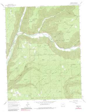
Stoner Topo Map Colorado
To zoom in, hover over the map of Stoner
USGS Topo Quad 37108e3 - 1:24,000 scale
| Topo Map Name: | Stoner |
| USGS Topo Quad ID: | 37108e3 |
| Print Size: | ca. 21 1/4" wide x 27" high |
| Southeast Coordinates: | 37.5° N latitude / 108.25° W longitude |
| Map Center Coordinates: | 37.5625° N latitude / 108.3125° W longitude |
| U.S. State: | CO |
| Filename: | o37108e3.jpg |
| Download Map JPG Image: | Stoner topo map 1:24,000 scale |
| Map Type: | Topographic |
| Topo Series: | 7.5´ |
| Map Scale: | 1:24,000 |
| Source of Map Images: | United States Geological Survey (USGS) |
| Alternate Map Versions: |
Stoner CO 1963, updated 1964 Download PDF Buy paper map Stoner CO 1963, updated 1972 Download PDF Buy paper map Stoner CO 1963, updated 1986 Download PDF Buy paper map Stoner CO 1963, updated 1986 Download PDF Buy paper map Stoner CO 2011 Download PDF Buy paper map Stoner CO 2013 Download PDF Buy paper map Stoner CO 2016 Download PDF Buy paper map |
| FStopo: | US Forest Service topo Stoner is available: Download FStopo PDF Download FStopo TIF |
1:24,000 Topo Quads surrounding Stoner
> Back to 37108e1 at 1:100,000 scale
> Back to 37108a1 at 1:250,000 scale
> Back to U.S. Topo Maps home
Stoner topo map: Gazetteer
Stoner: Lakes
Dry Lake elevation 2664m 8740′Taylor Mesa Lake elevation 2776m 9107′
Stoner: Populated Places
Stoner elevation 2278m 7473′Stoner: Reservoirs
Akin Reservoir elevation 2573m 8441′Big Hill Reservoir elevation 2650m 8694′
Garbareno Reservoir elevation 2727m 8946′
Gould Reservoir elevation 2772m 9094′
Haycamp Point Reservoir elevation 2451m 8041′
Hondo Reservoir elevation 2569m 8428′
Indian Draw Reservoir elevation 2624m 8608′
Jubal Reservoir elevation 2838m 9311′
Knuckles Reservoir elevation 2787m 9143′
Loading Pen Reservoir elevation 2767m 9078′
Long Draw Reservoir elevation 2740m 8989′
Longwill Reservoir elevation 2635m 8645′
Myler Reservoir elevation 2771m 9091′
Oak Knolls Reservoir elevation 2632m 8635′
Porter Reservoir elevation 2687m 8815′
Reef Pasture Reservoir elevation 2487m 8159′
Rocky Draw Number Three Reservoir elevation 2611m 8566′
Small Reservoir elevation 2851m 9353′
Smoothing Iron Reservoir elevation 2505m 8218′
Spruce Reservoir elevation 2587m 8487′
Stoner Point Reservoir elevation 2691m 8828′
Stoner Point Reservoir Number 2 elevation 2696m 8845′
Stoner Point Reservoir Number 3 elevation 2676m 8779′
Sutton Reservoir elevation 2787m 9143′
Thomas Reservoir elevation 2499m 8198′
Trail Reservoir elevation 2635m 8645′
Wallace Reservoir elevation 2463m 8080′
Wesley Reservoir elevation 2595m 8513′
Stoner: Springs
Cedar Spring elevation 2433m 7982′Coalbank Spring elevation 2535m 8316′
Haycamp Spring elevation 2632m 8635′
Longwill Spring elevation 2578m 8458′
Rock Spring elevation 2502m 8208′
Sttep Spring elevation 2627m 8618′
Vick Spring elevation 2515m 8251′
Wilkerson Spring elevation 2450m 8038′
Stoner: Streams
Fivemile Creek elevation 2382m 7814′Pipe Creek elevation 2286m 7500′
Rock Spring Creek elevation 2230m 7316′
Spring Creek elevation 2466m 8090′
Stoner Creek elevation 2306m 7565′
Taylor Creek elevation 2330m 7644′
West Dolores River elevation 2246m 7368′
Stoner: Valleys
Cox Canyon elevation 2240m 7349′Garrison Canyon elevation 2315m 7595′
Loading Pen Canyon elevation 2312m 7585′
Morgan Gulch elevation 2550m 8366′
Stoner digital topo map on disk
Buy this Stoner topo map showing relief, roads, GPS coordinates and other geographical features, as a high-resolution digital map file on DVD:


