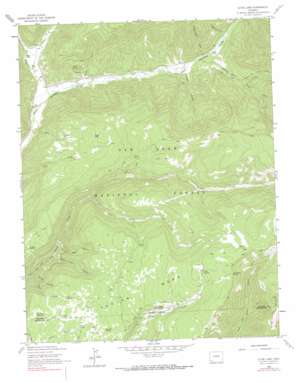
Clyde Lake Topo Map Colorado
To zoom in, hover over the map of Clyde Lake
USGS Topo Quad 37108f2 - 1:24,000 scale
| Topo Map Name: | Clyde Lake |
| USGS Topo Quad ID: | 37108f2 |
| Print Size: | ca. 21 1/4" wide x 27" high |
| Southeast Coordinates: | 37.625° N latitude / 108.125° W longitude |
| Map Center Coordinates: | 37.6875° N latitude / 108.1875° W longitude |
| U.S. State: | CO |
| Filename: | o37108f2.jpg |
| Download Map JPG Image: | Clyde Lake topo map 1:24,000 scale |
| Map Type: | Topographic |
| Topo Series: | 7.5´ |
| Map Scale: | 1:24,000 |
| Source of Map Images: | United States Geological Survey (USGS) |
| Alternate Map Versions: |
Clyde Lake CO 1963, updated 1965 Download PDF Buy paper map Clyde Lake CO 1963, updated 1972 Download PDF Buy paper map Clyde Lake CO 1963, updated 1990 Download PDF Buy paper map Clyde Lake CO 1963, updated 1990 Download PDF Buy paper map Clyde Lake CO 2011 Download PDF Buy paper map Clyde Lake CO 2013 Download PDF Buy paper map Clyde Lake CO 2016 Download PDF Buy paper map |
| FStopo: | US Forest Service topo Clyde Lake is available: Download FStopo PDF Download FStopo TIF |
1:24,000 Topo Quads surrounding Clyde Lake
> Back to 37108e1 at 1:100,000 scale
> Back to 37108a1 at 1:250,000 scale
> Back to U.S. Topo Maps home
Clyde Lake topo map: Gazetteer
Clyde Lake: Lakes
Clyde Lake elevation 2859m 9379′Clyde Lake: Mines
Little Silver Mine elevation 2632m 8635′Privateer Mine elevation 2778m 9114′
Teaser Mine elevation 2525m 8284′
Clyde Lake: Reservoirs
Aspen Reservoir elevation 2901m 9517′Auto Way Spring Reservoir elevation 2830m 9284′
Cattail Reservoir elevation 3122m 10242′
Cleveland Reservoir elevation 2745m 9005′
CLyde Lake Reservoir elevation 2838m 9311′
Corrals Reservoir elevation 2862m 9389′
Cresto Spring Reservoir elevation 2633m 8638′
Fox Den Reservoir elevation 2872m 9422′
Gate Reservoir elevation 2491m 8172′
Jose Spring Reservoir elevation 2757m 9045′
Juan Spring Reservoir elevation 2878m 9442′
Knight Spring Reservoir elevation 3021m 9911′
Pine Spring Reservoir elevation 2558m 8392′
Point Reservoir elevation 2877m 9438′
Rock Reservoir elevation 2881m 9452′
Royce Reservoir elevation 2781m 9124′
Seep Reservoir elevation 2970m 9744′
Slide Reservoir elevation 3020m 9908′
Sunshine Reservoir elevation 2869m 9412′
Swank Reservoir elevation 3081m 10108′
Twin Spring Reservoir elevation 2997m 9832′
Yearling Reservoir elevation 3081m 10108′
Clyde Lake: Springs
Cabin Spring elevation 2951m 9681′Camp Spring elevation 3068m 10065′
Cresto Spring elevation 2671m 8763′
Cub Spring elevation 2927m 9603′
Fivemile Spring elevation 3002m 9849′
Road Spring elevation 3248m 10656′
Soft Water Spring elevation 3247m 10652′
Twin Spring elevation 3017m 9898′
Clyde Lake: Streams
Cub Creek elevation 2519m 8264′Deer Creek elevation 2424m 7952′
Fish Creek elevation 2450m 8038′
Groundhog Creek elevation 2472m 8110′
Johnny Bull Creek elevation 2637m 8651′
Silver Creek elevation 2770m 9087′
Spring Creek elevation 2696m 8845′
Sulphur Creek elevation 2550m 8366′
Clyde Lake: Summits
Taylor Mesa elevation 3272m 10734′Clyde Lake: Trails
Eagle Peak Trail elevation 2543m 8343′Pipe Creek Trail elevation 3031m 9944′
Priest Gulch Trail elevation 2906m 9534′
Spring Creek Trail elevation 2816m 9238′
Stoner Mesa Trail elevation 2927m 9603′
Twin Spring Trail elevation 2866m 9402′
Clyde Lake: Valleys
Big Hell Canyon elevation 2571m 8435′Copper Gulch elevation 2532m 8307′
Deadman Draw elevation 2625m 8612′
Little Hell Canyon elevation 2583m 8474′
Schoolhouse Draw elevation 2591m 8500′
Sheep Canyon elevation 2539m 8330′
Clyde Lake digital topo map on disk
Buy this Clyde Lake topo map showing relief, roads, GPS coordinates and other geographical features, as a high-resolution digital map file on DVD:


