Nipple Mountain Topo Map Colorado
To zoom in, hover over the map of Nipple Mountain
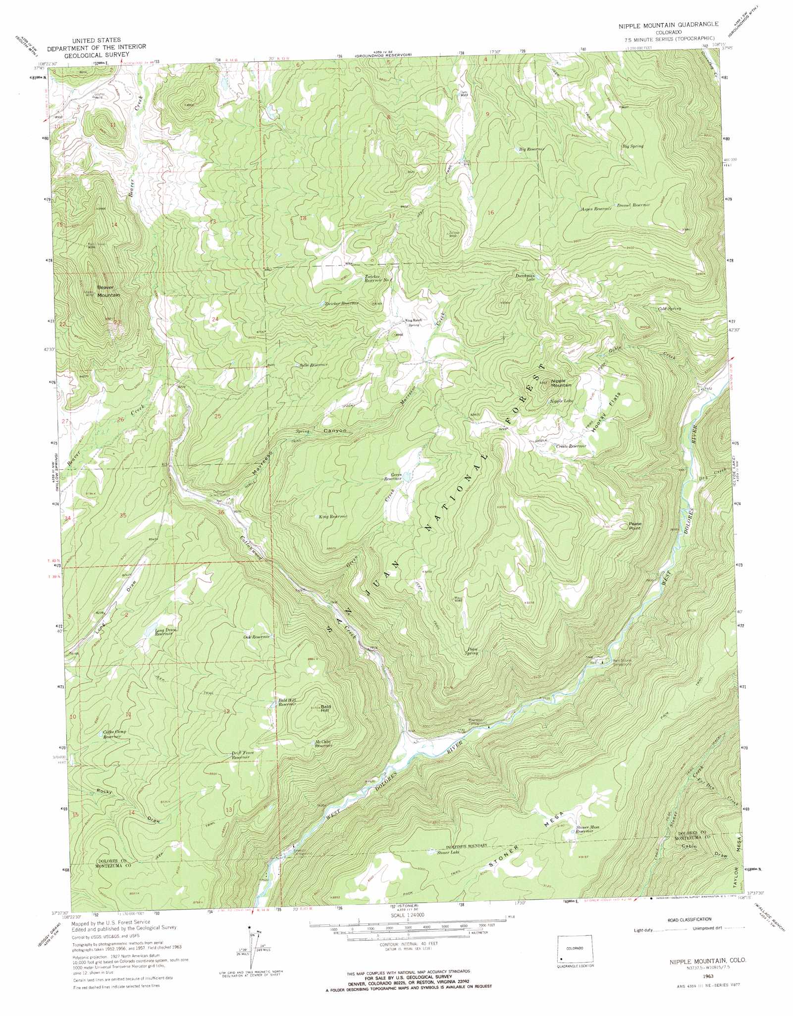
USGS Topo Quad 37108f3 - 1:24,000 scale
| Topo Map Name: | Nipple Mountain |
| USGS Topo Quad ID: | 37108f3 |
| Print Size: | ca. 21 1/4" wide x 27" high |
| Southeast Coordinates: | 37.625° N latitude / 108.25° W longitude |
| Map Center Coordinates: | 37.6875° N latitude / 108.3125° W longitude |
| U.S. State: | CO |
| Filename: | o37108f3.jpg |
| Download Map JPG Image: | Nipple Mountain topo map 1:24,000 scale |
| Map Type: | Topographic |
| Topo Series: | 7.5´ |
| Map Scale: | 1:24,000 |
| Source of Map Images: | United States Geological Survey (USGS) |
| Alternate Map Versions: |
Nipple Mountain CO 1963, updated 1965 Download PDF Buy paper map Nipple Mountain CO 1963, updated 1965 Download PDF Buy paper map Nipple Mountain CO 1963, updated 1972 Download PDF Buy paper map Nipple Mountain CO 2011 Download PDF Buy paper map Nipple Mountain CO 2013 Download PDF Buy paper map Nipple Mountain CO 2016 Download PDF Buy paper map |
| FStopo: | US Forest Service topo Nipple Mountain is available: Download FStopo PDF Download FStopo TIF |
1:24,000 Topo Quads surrounding Nipple Mountain
Mckenna Peak |
North Mountain |
Lone Cone |
Beaver Park |
Little Cone |
Glade Mountain |
South Mountain |
Groundhog Reservoir |
Groundhog Mountain |
Dolores Peak |
Narraguinnep Mountain |
Willow Spring |
Nipple Mountain |
Clyde Lake |
Rico |
Trimble Point |
Boggy Draw |
Stoner |
Wallace Ranch |
Orphan Butte |
Dolores West |
Dolores East |
Millwood |
Rampart Hills |
La Plata |
> Back to 37108e1 at 1:100,000 scale
> Back to 37108a1 at 1:250,000 scale
> Back to U.S. Topo Maps home
Nipple Mountain topo map: Gazetteer
Nipple Mountain: Cliffs
Pease Point elevation 2802m 9192′Nipple Mountain: Flats
Hooray Flats elevation 2769m 9084′Hugh Ray Flats elevation 2771m 9091′
Nipple Mountain: Lakes
Dutchman Lake elevation 2852m 9356′Nipple Lake elevation 2864m 9396′
Stoner Lake elevation 2753m 9032′
Nipple Mountain: Reservoirs
Aspen Reservoir elevation 2927m 9603′Bald Hill Reservoir elevation 2708m 8884′
Baldy Reservoir elevation 2630m 8628′
Bench Reservoir elevation 2610m 8562′
Bench Spring Reservoir elevation 2726m 8943′
Big Reservoir elevation 2834m 9297′
Big Spring Reservoir elevation 2911m 9550′
Coffee Camp Reservoir elevation 2536m 8320′
Cresto Reservoir elevation 2820m 9251′
Dressel Number Two Reservoir elevation 2943m 9655′
Dressel Reservoir elevation 2953m 9688′
Drift Fence Reservoir elevation 2696m 8845′
Franks Reservoir elevation 2765m 9071′
Geren Reservoir elevation 2708m 8884′
Goble Canyon Reservoir elevation 2921m 9583′
Hap Reservoir elevation 2780m 9120′
King Number Two Reservoir elevation 2765m 9071′
King Reservoir elevation 2663m 8736′
Koeing Reservoir elevation 2778m 9114′
Leonia Reservoir elevation 2474m 8116′
Lila Reservoir elevation 2768m 9081′
Long Draw Reservoir elevation 2541m 8336′
McCabe Reservoir elevation 2729m 8953′
McEwen Reservoir elevation 2797m 9176′
Michele Reservoir elevation 2732m 8963′
North Reservoir elevation 2736m 8976′
Oak Reservoir elevation 2647m 8684′
Only Reservoir elevation 2552m 8372′
Pease Point Reservoir elevation 2877m 9438′
Pease Reservoir elevation 2808m 9212′
Quakie Reservoir elevation 2744m 9002′
Rocky Draw Number One Reservoir elevation 2668m 8753′
Silbo Reservoir elevation 2621m 8599′
South Reservoir elevation 2753m 9032′
Steer Number Eight Reservoir elevation 2683m 8802′
Steer Number Five Reservoir elevation 2481m 8139′
Steer Number Four Reservoir elevation 2618m 8589′
Steer Number One Reservoir elevation 2482m 8143′
Steer Number Seven Reservoir elevation 2670m 8759′
Steer Number Six Reservoir elevation 2536m 8320′
Steer Number Three Reservoir elevation 2584m 8477′
Steer Number Two Reservoir elevation 2641m 8664′
Steer Number Two Reservoir elevation 2674m 8772′
Stoner Mesa Reservoir elevation 2790m 9153′
Ted Reservoir elevation 2711m 8894′
Trail Reservoir elevation 2608m 8556′
Waterhole Reservoir elevation 2547m 8356′
Wild Cow Reservoir elevation 2722m 8930′
Zwicker Reservoir elevation 2731m 8959′
Zwicker Reservoir Number 2 elevation 2757m 9045′
Nipple Mountain: Springs
Big Spring elevation 2924m 9593′Cold Spring elevation 2665m 8743′
Pease Spring elevation 2763m 9064′
Nipple Mountain: Streams
Cottonwood Creek elevation 2319m 7608′Dry Creek elevation 2395m 7857′
Fox Den Creek elevation 2471m 8106′
Geren Creek elevation 2414m 7919′
Goble Creek elevation 2410m 7906′
Mavreeso Creek elevation 2457m 8061′
Nipple Mountain: Summits
Bald Hill elevation 2796m 9173′Beaver Mountain elevation 2836m 9304′
Nipple Mountain elevation 2978m 9770′
Stoner Mesa elevation 2812m 9225′
Nipple Mountain: Trails
Goble Trail elevation 2789m 9150′Stoner Stock Trail elevation 2635m 8645′
Nipple Mountain: Valleys
Cabin Draw elevation 2468m 8097′Mavreeso Canyon elevation 2463m 8080′
Nipple Mountain digital topo map on disk
Buy this Nipple Mountain topo map showing relief, roads, GPS coordinates and other geographical features, as a high-resolution digital map file on DVD: