The Glade Topo Map Colorado
To zoom in, hover over the map of The Glade
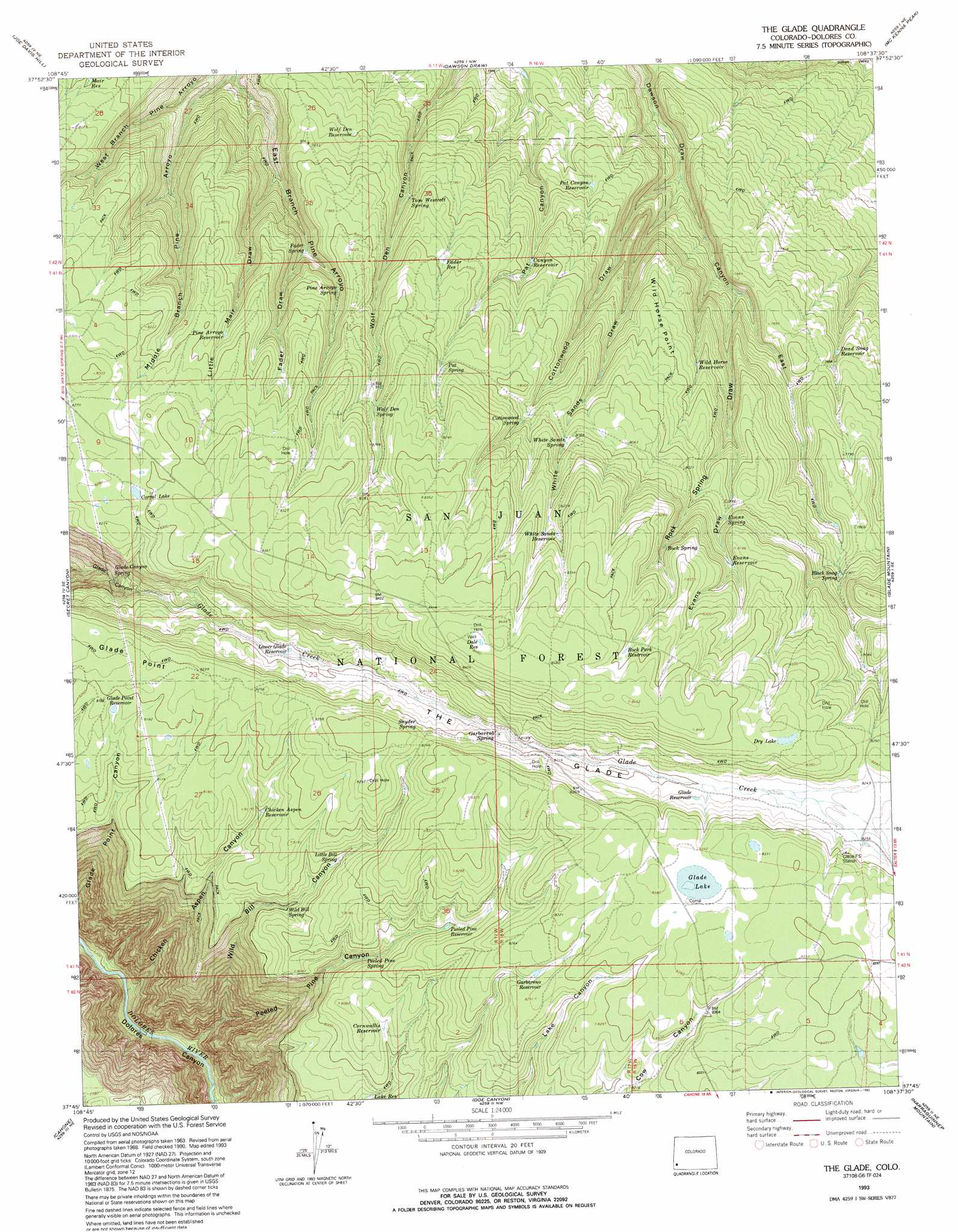
USGS Topo Quad 37108g6 - 1:24,000 scale
| Topo Map Name: | The Glade |
| USGS Topo Quad ID: | 37108g6 |
| Print Size: | ca. 21 1/4" wide x 27" high |
| Southeast Coordinates: | 37.75° N latitude / 108.625° W longitude |
| Map Center Coordinates: | 37.8125° N latitude / 108.6875° W longitude |
| U.S. State: | CO |
| Filename: | o37108g6.jpg |
| Download Map JPG Image: | The Glade topo map 1:24,000 scale |
| Map Type: | Topographic |
| Topo Series: | 7.5´ |
| Map Scale: | 1:24,000 |
| Source of Map Images: | United States Geological Survey (USGS) |
| Alternate Map Versions: |
The Glade CO 1964, updated 1968 Download PDF Buy paper map The Glade CO 1964, updated 1968 Download PDF Buy paper map The Glade CO 1964, updated 1991 Download PDF Buy paper map The Glade CO 1993, updated 1993 Download PDF Buy paper map The Glade CO 2011 Download PDF Buy paper map The Glade CO 2013 Download PDF Buy paper map The Glade CO 2016 Download PDF Buy paper map |
| FStopo: | US Forest Service topo The Glade is available: Download FStopo PDF Download FStopo TIF |
1:24,000 Topo Quads surrounding The Glade
Horse Range Mesa |
Hamm Canyon |
Gypsum Gap |
Basin |
Barkelew Draw |
Egnar |
Joe Davis Hill |
Dawson Draw |
Mckenna Peak |
North Mountain |
Dove Creek |
Secret Canyon |
The Glade |
Glade Mountain |
South Mountain |
Champagne Spring |
Cahone |
Doe Canyon |
Narraguinnep Mountain |
Willow Spring |
Ruin Canyon |
Pleasant View |
Yellow Jacket |
Trimble Point |
Boggy Draw |
> Back to 37108e1 at 1:100,000 scale
> Back to 37108a1 at 1:250,000 scale
> Back to U.S. Topo Maps home
The Glade topo map: Gazetteer
The Glade: Cliffs
Glade Point elevation 2503m 8211′Wild Horse Point elevation 2379m 7805′
The Glade: Lakes
Corral Lake elevation 2529m 8297′Dry Lake elevation 2554m 8379′
Glade Lake elevation 2548m 8359′
The Glade: Reservoirs
Albert Reservoir elevation 2478m 8129′Bear Reservoir elevation 2527m 8290′
Big Water Number Four Reservoir elevation 2555m 8382′
Big Water Reservoir Number Five elevation 2524m 8280′
Big Water Reservoir Number Seven elevation 2501m 8205′
Big Water Reservoir Number Six elevation 2507m 8225′
Big Water Reservoir Number Ten elevation 2479m 8133′
Big Water Reservoir Number Three elevation 2521m 8270′
Black Snag Reservoir elevation 2401m 7877′
Canyon Reservoir elevation 2381m 7811′
Chicken Aspen Reservoir elevation 2469m 8100′
Cornwallis Reservoir elevation 2444m 8018′
Cottonwood Gulch Reservoir elevation 2550m 8366′
Dale Reservoir elevation 2584m 8477′
Dawson Reservoir elevation 2353m 7719′
Dead Snag Reservoir elevation 2313m 7588′
Evans Reservoir elevation 2468m 8097′
Fader Reservoir elevation 2434m 7985′
Garbareno Reservoir elevation 2517m 8257′
Glade Point Reservoir elevation 2488m 8162′
Glade Reservoir elevation 2508m 8228′
Lake Reservoir elevation 2416m 7926′
Lake Unit Number Four Reservoir elevation 2501m 8205′
Lake Unit Number Three Reservoir elevation 2516m 8254′
Lake Unit Number Two Reservoir elevation 2543m 8343′
Lower Glade Reservoir elevation 2463m 8080′
Luggan Reservoir elevation 2479m 8133′
Main Reservoir elevation 2438m 7998′
Muhly Reservoir elevation 2444m 8018′
Pat Canyon Reservoir elevation 2332m 7650′
Peeled Pine Reservoir elevation 2469m 8100′
Pine Arroyo Reservoir elevation 2475m 8120′
Rock Park Reservoir elevation 2556m 8385′
White Sands Reservoir elevation 2523m 8277′
Wild Bill Number Eleven Reservoir elevation 2486m 8156′
Wild Bill Number Five Reservoir elevation 2499m 8198′
Wild Bill Number Four Reservoir elevation 2510m 8234′
Wild Bill Number Fourteen Reservoir elevation 2453m 8047′
Wild Bill Number Nine Reservoir elevation 2500m 8202′
Wild Bill Number Six Reservoir elevation 2463m 8080′
Wild Bill Number Ten Reservoir elevation 2500m 8202′
Wild Bill Number Thirteen Reservoir elevation 2475m 8120′
Wild Bill Number Three Reservoir elevation 2499m 8198′
Wild Bill Number Twelve Reservoir elevation 2425m 7956′
Wild Bill Number Two Reservoir elevation 2485m 8152′
Wild Bill Number Two Reservoir elevation 2510m 8234′
Wild Horse Reservoir elevation 2383m 7818′
Wolf Den Reservoir elevation 2378m 7801′
The Glade: Springs
Black Snag Spring elevation 2409m 7903′Cottonwood Spring elevation 2461m 8074′
Evans Spring elevation 2440m 8005′
Fader Spring elevation 2367m 7765′
Garbarero Spring elevation 2489m 8166′
Glade Canyon Spring elevation 2368m 7769′
Little Bill Spring elevation 2465m 8087′
Pat Spring elevation 2473m 8113′
Peeled Pine Spring elevation 2434m 7985′
Pine Arroyo Spring elevation 2404m 7887′
Rock Spring elevation 2494m 8182′
Snyder Spring elevation 2504m 8215′
Tom Westcott Spring elevation 2373m 7785′
White Sands Spring elevation 2459m 8067′
Wild Bill Spring elevation 2432m 7979′
Wolf Den Spring elevation 2480m 8136′
The Glade: Valleys
Canyon East elevation 2206m 7237′Chicken Aspen Canyon elevation 1940m 6364′
Cottonwood Draw elevation 2206m 7237′
East Branch Pine Arroyo elevation 2262m 7421′
Evans Draw elevation 2369m 7772′
Fader Draw elevation 2363m 7752′
Little Main Draw elevation 2318m 7604′
Peeled Pine Canyon elevation 1944m 6377′
Rock Spring Draw elevation 2271m 7450′
The Glade elevation 2440m 8005′
White Sands Draws elevation 2206m 7237′
Wild Bill Canyon elevation 1952m 6404′
The Glade digital topo map on disk
Buy this The Glade topo map showing relief, roads, GPS coordinates and other geographical features, as a high-resolution digital map file on DVD: