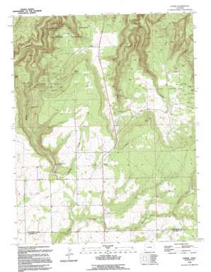
Egnar Topo Map Colorado
To zoom in, hover over the map of Egnar
USGS Topo Quad 37108h8 - 1:24,000 scale
| Topo Map Name: | Egnar |
| USGS Topo Quad ID: | 37108h8 |
| Print Size: | ca. 21 1/4" wide x 27" high |
| Southeast Coordinates: | 37.875° N latitude / 108.875° W longitude |
| Map Center Coordinates: | 37.9375° N latitude / 108.9375° W longitude |
| U.S. State: | CO |
| Filename: | o37108h8.jpg |
| Download Map JPG Image: | Egnar topo map 1:24,000 scale |
| Map Type: | Topographic |
| Topo Series: | 7.5´ |
| Map Scale: | 1:24,000 |
| Source of Map Images: | United States Geological Survey (USGS) |
| Alternate Map Versions: |
Egnar CO 1949 Download PDF Buy paper map Egnar CO 1949, updated 1957 Download PDF Buy paper map Egnar CO 1949, updated 1957 Download PDF Buy paper map Egnar CO 1949, updated 1991 Download PDF Buy paper map Egnar CO 1950 Download PDF Buy paper map Egnar CO 1950 Download PDF Buy paper map Egnar CO 1994, updated 1994 Download PDF Buy paper map Egnar CO 2010 Download PDF Buy paper map Egnar CO 2013 Download PDF Buy paper map Egnar CO 2016 Download PDF Buy paper map |
1:24,000 Topo Quads surrounding Egnar
> Back to 37108e1 at 1:100,000 scale
> Back to 37108a1 at 1:250,000 scale
> Back to U.S. Topo Maps home
Egnar topo map: Gazetteer
Egnar: Flats
The Spud Patch elevation 2276m 7467′Egnar: Mines
Allison Drilling Company Mine elevation 2233m 7326′Ann Number One Mine elevation 2175m 7135′
Ann Number Two Mine elevation 2184m 7165′
Barkley Lease Mine elevation 2238m 7342′
Bessie Mine elevation 2205m 7234′
Big Chief Mine elevation 2249m 7378′
Bishop Canyon Mine elevation 2116m 6942′
Black Jack Mine elevation 2149m 7050′
Boondock Number One Mine elevation 2236m 7335′
Charles P Mine elevation 2236m 7335′
Chief One Mine elevation 2141m 7024′
Cowgirl Number Two Mine elevation 2100m 6889′
Dorothy Mae Mine elevation 2239m 7345′
Easton B Mine elevation 2239m 7345′
Effie B. Mine elevation 2158m 7080′
Falcon Mine elevation 2136m 7007′
Frankie Mine elevation 2158m 7080′
Frenchie Point Mine elevation 2052m 6732′
Frenchie Rim Mine elevation 2098m 6883′
Frenchy Two Mine elevation 2116m 6942′
Fritz-Erickson Mine elevation 2044m 6706′
Full Moon Number Two Mine elevation 2238m 7342′
Goforth Homestead Mine elevation 2195m 7201′
Golden Rod Mines elevation 2177m 7142′
Goldenrod Number Five Mine elevation 2182m 7158′
Governor Mine elevation 2107m 6912′
Hangover Mine elevation 2170m 7119′
Hawk Mine elevation 2134m 7001′
Hawk-Frankie Mine elevation 2154m 7066′
Independence Mine elevation 2079m 6820′
J. B. Crawley Mines elevation 2239m 7345′
Joe Bush Group Mine elevation 2196m 7204′
Jupiter Mine elevation 2311m 7582′
Katie Mine elevation 2219m 7280′
Keystone Mine elevation 2208m 7244′
King Mine elevation 2095m 6873′
Latricia Mine elevation 1925m 6315′
Legin Mines elevation 2109m 6919′
Little Helen Mine elevation 2078m 6817′
Little Max Mine elevation 2266m 7434′
Lone Park Number Two Mine elevation 2278m 7473′
Lone Peak Mine elevation 2139m 7017′
Lost Dog Mine elevation 1987m 6519′
Lucky Day Mine elevation 2165m 7103′
Lucky J Mine elevation 2278m 7473′
Marie One Mine elevation 2062m 6765′
Marne Group Mine elevation 2301m 7549′
May Number One Mine elevation 2123m 6965′
May Number Three Mine elevation 2123m 6965′
May Number Two Mine elevation 2123m 6965′
Mayday Mine elevation 2250m 7381′
McCormick Shaft Mine elevation 2044m 6706′
Mercantile Bright Mine elevation 2103m 6899′
Michael Bray Mine elevation 2181m 7155′
Mickey Mine elevation 2236m 7335′
Mickey Three Mine elevation 1974m 6476′
Montezuma Mine elevation 2227m 7306′
Moqui Jug Mine elevation 2257m 7404′
Mucha Grande Mine elevation 2283m 7490′
Nelson and Larson Mine elevation 2233m 7326′
Norma Jean Number Two Mine elevation 2253m 7391′
Ocumpaugh Mine elevation 2283m 7490′
Oliver Vanadium Mine elevation 2312m 7585′
O'Neill Group Mines elevation 2228m 7309′
Ortmayer Lease Mine elevation 2283m 7490′
Owenby Group Mine elevation 2283m 7490′
Paper Ore Body Mine elevation 2283m 7490′
Pay Lode Numbers One-Five Mines elevation 2218m 7276′
Paystreak Number Three Mine elevation 2264m 7427′
Penigal Mine elevation 2241m 7352′
Pine Bug Mine elevation 2104m 6902′
Queen of Spades Mine elevation 2033m 6669′
Rattlesnake Mine elevation 2100m 6889′
Roger Number One Mine elevation 2283m 7490′
Sam Mine elevation 2121m 6958′
Santa Maria Mine elevation 2208m 7244′
Schlee Mine elevation 2133m 6998′
Sibley Mine elevation 2100m 6889′
Star Mine elevation 2271m 7450′
Strawberry Roan Mine elevation 2031m 6663′
Strawberry Roan Mine elevation 2035m 6676′
Summit Mine elevation 2193m 7194′
Teton Exploration Mine elevation 2233m 7326′
Uintah Mine elevation 2111m 6925′
Uintah Two Lode elevation 2102m 6896′
Victor Number Three Mine elevation 2233m 7326′
Victor Two Mine elevation 1942m 6371′
Wilson Mine elevation 2283m 7490′
Egnar: Populated Places
Egnar elevation 2234m 7329′Egnar: Springs
Bishop Canyon Spring elevation 2164m 7099′Overall Spring elevation 2298m 7539′
Egnar: Streams
Bell Creek elevation 1943m 6374′North Branch Chico Creek elevation 2240m 7349′
Egnar: Valleys
Bishop Canyon elevation 1885m 6184′Egnar digital topo map on disk
Buy this Egnar topo map showing relief, roads, GPS coordinates and other geographical features, as a high-resolution digital map file on DVD:


