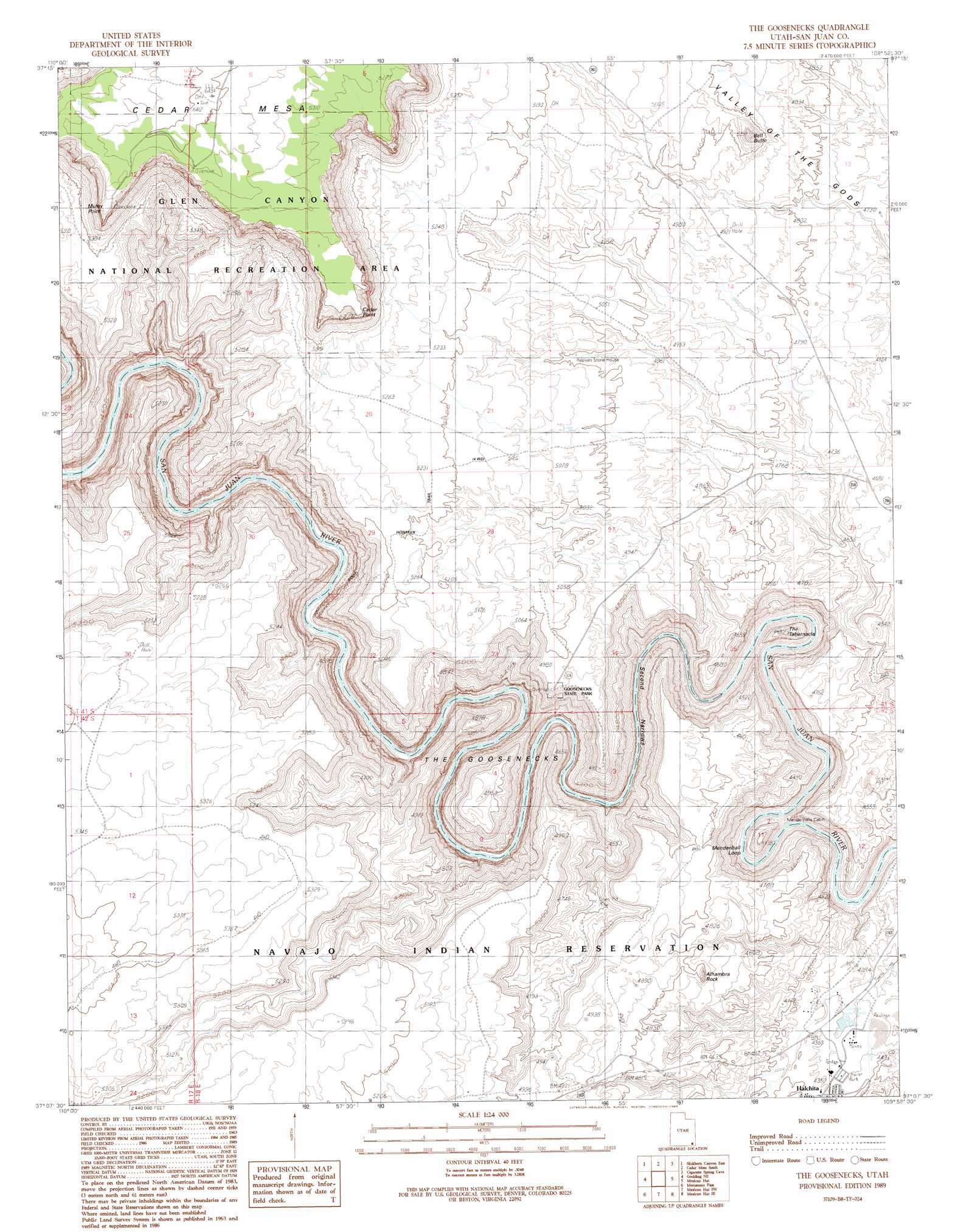
The Goosenecks Topo Map Utah
To zoom in, hover over the map of The Goosenecks
USGS Topo Quad 37109b8 - 1:24,000 scale
| Topo Map Name: | The Goosenecks |
| USGS Topo Quad ID: | 37109b8 |
| Print Size: | ca. 21 1/4" wide x 27" high |
| Southeast Coordinates: | 37.125° N latitude / 109.875° W longitude |
| Map Center Coordinates: | 37.1875° N latitude / 109.9375° W longitude |
| U.S. State: | UT |
| Filename: | o37109b8.jpg |
| Download Map JPG Image: | The Goosenecks topo map 1:24,000 scale |
| Map Type: | Topographic |
| Topo Series: | 7.5´ |
| Map Scale: | 1:24,000 |
| Source of Map Images: | United States Geological Survey (USGS) |
| Alternate Map Versions: |
The Goosenecks UT 1989, updated 1989 Download PDF Buy paper map The Goosenecks UT 1989, updated 1989 Download PDF Buy paper map The Goosenecks UT 2010 Download PDF Buy paper map The Goosenecks UT 2014 Download PDF Buy paper map |
1:24,000 Topo Quads surrounding The Goosenecks
Red House Spring |
Pollys Pasture |
Cedar Mesa North |
Snow Flat Spring Cave |
Bluff Nw |
Slickhorn Canyon West |
Slickhorn Canyon East |
Cedar Mesa South |
Cigarette Spring Cave |
Bluff Sw |
Goulding Nw |
Goulding Ne |
The Goosenecks |
Mexican Hat |
San Juan Hill |
Goulding |
Monument Pass |
Mexican Hat Sw |
Mexican Hat Se |
Moses Rock |
Mystery Valley |
Mitten Buttes |
Rooster Rock |
Garnet Ridge |
Mexican Water |
> Back to 37109a1 at 1:100,000 scale
> Back to 37108a1 at 1:250,000 scale
> Back to U.S. Topo Maps home
The Goosenecks topo map: Gazetteer
The Goosenecks: Bends
Mendenhall Loop elevation 1288m 4225′The Goosenecks elevation 1440m 4724′
The Goosenecks: Cliffs
Cedar Point elevation 1895m 6217′Muley Point elevation 1899m 6230′
The Goosenecks: Parks
Goosenecks of the San Juan River State Park elevation 1440m 4724′Goosenecks State Park elevation 1521m 4990′
The Goosenecks: Pillars
Alhambra Rock elevation 1478m 4849′The Goosenecks: Populated Places
Halchita elevation 1335m 4379′The Goosenecks: Post Offices
Mexican Post Office elevation 1337m 4386′The Goosenecks: Ridges
Goodridge Rocks elevation 1251m 4104′The Goosenecks: Summits
Bell Butte elevation 1613m 5291′The Tabernacle elevation 1336m 4383′
The Goosenecks: Trails
Honaker Trail elevation 1589m 5213′The Goosenecks: Valleys
Second Narrows elevation 1218m 3996′The Goosenecks digital topo map on disk
Buy this The Goosenecks topo map showing relief, roads, GPS coordinates and other geographical features, as a high-resolution digital map file on DVD: