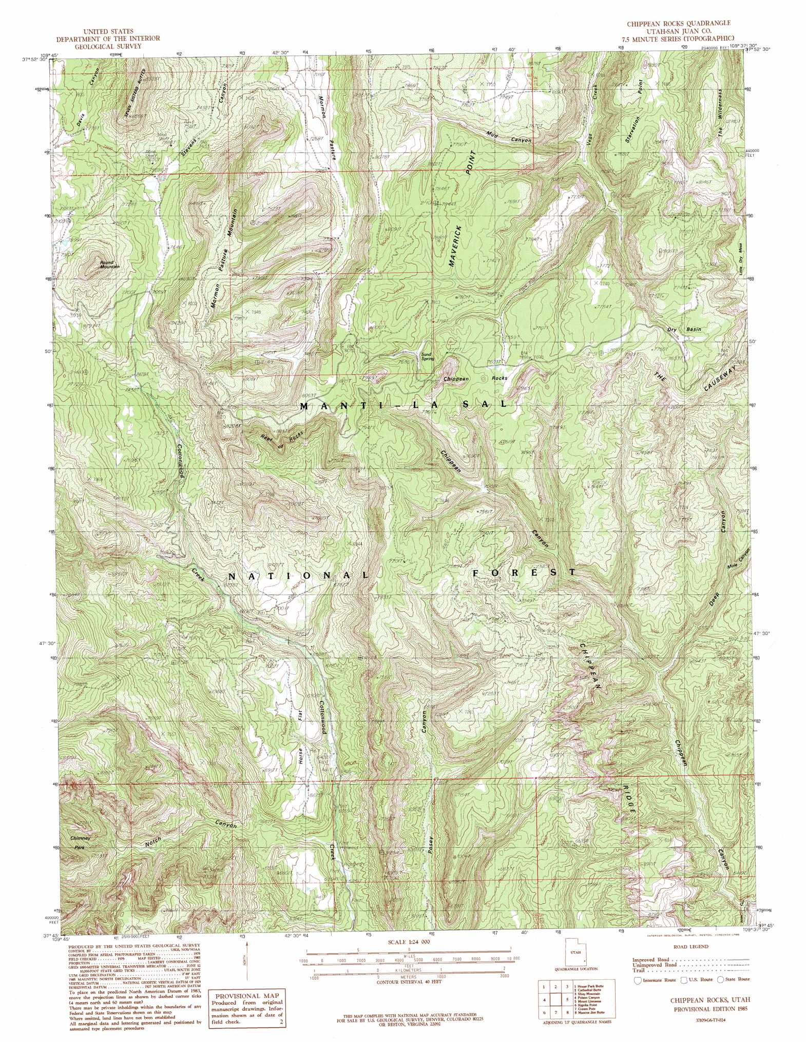
Chippean Rocks Topo Map Utah
To zoom in, hover over the map of Chippean Rocks
USGS Topo Quad 37109g6 - 1:24,000 scale
| Topo Map Name: | Chippean Rocks |
| USGS Topo Quad ID: | 37109g6 |
| Print Size: | ca. 21 1/4" wide x 27" high |
| Southeast Coordinates: | 37.75° N latitude / 109.625° W longitude |
| Map Center Coordinates: | 37.8125° N latitude / 109.6875° W longitude |
| U.S. State: | UT |
| Filename: | o37109g6.jpg |
| Download Map JPG Image: | Chippean Rocks topo map 1:24,000 scale |
| Map Type: | Topographic |
| Topo Series: | 7.5´ |
| Map Scale: | 1:24,000 |
| Source of Map Images: | United States Geological Survey (USGS) |
| Alternate Map Versions: |
Elk Ridge 1 SW UT 1954 Download PDF Buy paper map Chippean Rocks UT 1985, updated 1985 Download PDF Buy paper map Chippean Rocks UT 1985, updated 1985 Download PDF Buy paper map Chippean Rocks UT 2001, updated 2004 Download PDF Buy paper map Chippean Rocks UT 2011 Download PDF Buy paper map Chippean Rocks UT 2014 Download PDF Buy paper map |
| FStopo: | US Forest Service topo Chippean Rocks is available: Download FStopo PDF Download FStopo TIF |
1:24,000 Topo Quads surrounding Chippean Rocks
Cross Canyon |
Druid Arch |
South Six-Shooter Peak |
Harts Point South |
Photograph Gap |
Fable Valley |
House Park Butte |
Cathedral Butte |
Shay Mountain |
Monticello Lake |
Warren Canyon |
Poison Canyon |
Chippean Rocks |
Mount Linnaeus |
Abajo Peak |
Woodenshoe Buttes |
Kigalia Point |
Cream Pots |
Mancos Jim Butte |
Blanding North |
Kane Gulch |
South Long Point |
Hotel Rock |
Black Mesa Butte |
Blanding South |
> Back to 37109e1 at 1:100,000 scale
> Back to 37108a1 at 1:250,000 scale
> Back to U.S. Topo Maps home
Chippean Rocks topo map: Gazetteer
Chippean Rocks: Areas
The Wilderness elevation 2474m 8116′Chippean Rocks: Basins
Dry Basin elevation 2341m 7680′Chippean Rocks: Capes
Maverick Point elevation 2421m 7942′Starvation Point elevation 2382m 7814′
Chippean Rocks: Flats
Horse Flat elevation 2185m 7168′Mormon Pasture elevation 2207m 7240′
Chippean Rocks: Mines
Avalanche Mine elevation 2069m 6788′Black Bean Mine elevation 2064m 6771′
Chippean Rocks: Ridges
Chippean Ridge elevation 2285m 7496′Reef of Rocks elevation 2410m 7906′
Chippean Rocks: Springs
Sand Spring elevation 2342m 7683′Chippean Rocks: Summits
Chippean Rocks elevation 2338m 7670′Mormon Pasture Mountain elevation 2575m 8448′
Round Mountain elevation 2588m 8490′
Chippean Rocks: Valleys
Chippean Canyon elevation 1862m 6108′Deep Canyon elevation 1966m 6450′
Mud Canyon elevation 2097m 6879′
Mule Canyon elevation 2065m 6774′
Notch Canyon elevation 1928m 6325′
Chippean Rocks digital topo map on disk
Buy this Chippean Rocks topo map showing relief, roads, GPS coordinates and other geographical features, as a high-resolution digital map file on DVD: