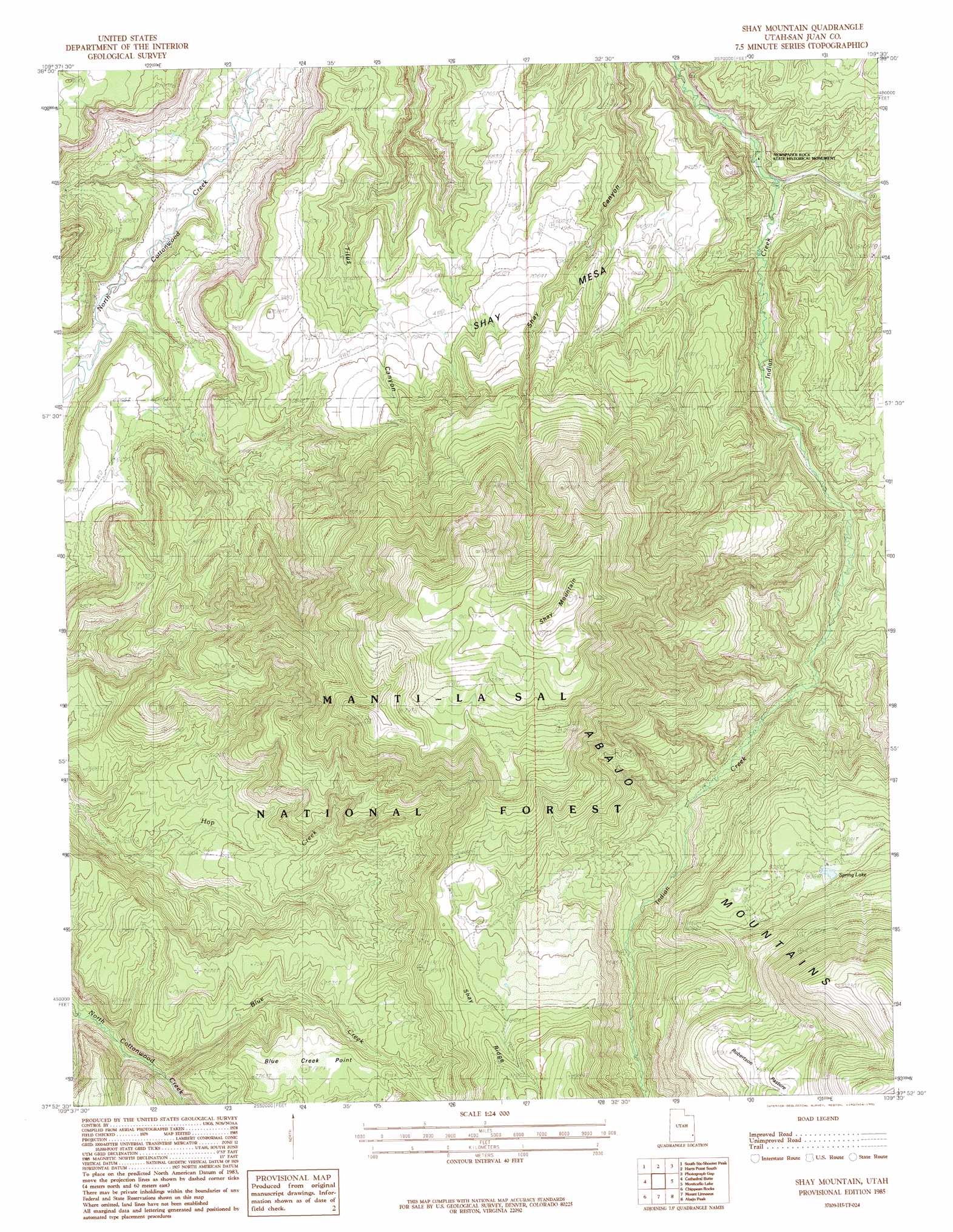
Shay Mountain Topo Map Utah
To zoom in, hover over the map of Shay Mountain
USGS Topo Quad 37109h5 - 1:24,000 scale
| Topo Map Name: | Shay Mountain |
| USGS Topo Quad ID: | 37109h5 |
| Print Size: | ca. 21 1/4" wide x 27" high |
| Southeast Coordinates: | 37.875° N latitude / 109.5° W longitude |
| Map Center Coordinates: | 37.9375° N latitude / 109.5625° W longitude |
| U.S. State: | UT |
| Filename: | o37109h5.jpg |
| Download Map JPG Image: | Shay Mountain topo map 1:24,000 scale |
| Map Type: | Topographic |
| Topo Series: | 7.5´ |
| Map Scale: | 1:24,000 |
| Source of Map Images: | United States Geological Survey (USGS) |
| Alternate Map Versions: |
Elk Ridge 1 NE UT 1954 Download PDF Buy paper map Shay Mountain UT 1985, updated 1985 Download PDF Buy paper map Shay Mountain UT 1985, updated 1991 Download PDF Buy paper map Shay Mountain UT 2001, updated 2004 Download PDF Buy paper map Shay Mountain UT 2011 Download PDF Buy paper map Shay Mountain UT 2014 Download PDF Buy paper map |
| FStopo: | US Forest Service topo Shay Mountain is available: Download FStopo PDF Download FStopo TIF |
1:24,000 Topo Quads surrounding Shay Mountain
The Loop |
North Six-Shooter Peak |
Harts Point North |
Hatch Rock |
Sandstone Draw |
Druid Arch |
South Six-Shooter Peak |
Harts Point South |
Photograph Gap |
Church Rock |
House Park Butte |
Cathedral Butte |
Shay Mountain |
Monticello Lake |
Monticello North |
Poison Canyon |
Chippean Rocks |
Mount Linnaeus |
Abajo Peak |
Monticello South |
Kigalia Point |
Cream Pots |
Mancos Jim Butte |
Blanding North |
Devil Mesa |
> Back to 37109e1 at 1:100,000 scale
> Back to 37108a1 at 1:250,000 scale
> Back to U.S. Topo Maps home
Shay Mountain topo map: Gazetteer
Shay Mountain: Dams
Spring Lake Dam elevation 2593m 8507′Shay Mountain: Flats
Robertson Pasture elevation 2905m 9530′Shay Mountain: Forests
Manti-La Sal National Forest - La Sal Division elevation 3158m 10360′Shay Mountain: Parks
Newspaper Rock State Historical Monument elevation 1874m 6148′Shay Mountain: Reservoirs
Spring Lake elevation 2593m 8507′Shay Mountain: Streams
Blue Creek elevation 2075m 6807′Shay Mountain: Summits
Blue Creek Point elevation 2360m 7742′Shay Mesa elevation 2127m 6978′
Shay Mountain elevation 3040m 9973′
Shay Mountain digital topo map on disk
Buy this Shay Mountain topo map showing relief, roads, GPS coordinates and other geographical features, as a high-resolution digital map file on DVD: