The Cheesebox Topo Map Utah
To zoom in, hover over the map of The Cheesebox
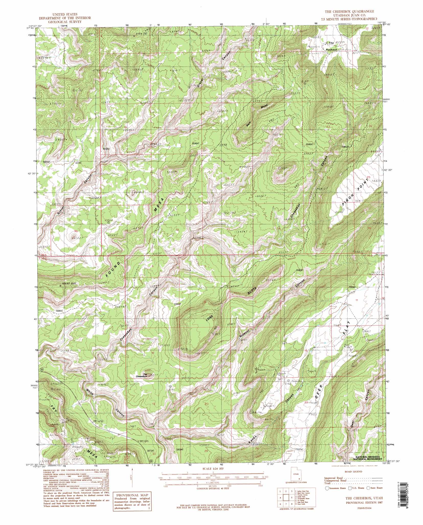
USGS Topo Quad 37110f1 - 1:24,000 scale
| Topo Map Name: | The Cheesebox |
| USGS Topo Quad ID: | 37110f1 |
| Print Size: | ca. 21 1/4" wide x 27" high |
| Southeast Coordinates: | 37.625° N latitude / 110° W longitude |
| Map Center Coordinates: | 37.6875° N latitude / 110.0625° W longitude |
| U.S. State: | UT |
| Filename: | o37110f1.jpg |
| Download Map JPG Image: | The Cheesebox topo map 1:24,000 scale |
| Map Type: | Topographic |
| Topo Series: | 7.5´ |
| Map Scale: | 1:24,000 |
| Source of Map Images: | United States Geological Survey (USGS) |
| Alternate Map Versions: |
White Canyon 4 NE UT 1954, updated 1954 Download PDF Buy paper map The Cheesebox UT 1987, updated 1987 Download PDF Buy paper map The Cheesebox UT 1987, updated 1987 Download PDF Buy paper map The Cheesebox UT 1987, updated 1987 Download PDF Buy paper map The Cheesebox UT 2011 Download PDF Buy paper map The Cheesebox UT 2014 Download PDF Buy paper map |
1:24,000 Topo Quads surrounding The Cheesebox
Sewing Machine |
Bowdie Canyon West |
Bowdie Canyon East |
Fable Valley |
House Park Butte |
Copper Point |
Indian Head Pass |
Black Steer Canyon |
Warren Canyon |
Poison Canyon |
Mancos Mesa Ne |
Jacobs Chair |
The Cheesebox |
Woodenshoe Buttes |
Kigalia Point |
Chocolate Drop |
Fry Spring |
Moss Back Butte |
Kane Gulch |
South Long Point |
Clay Hills |
Red House Spring |
Pollys Pasture |
Cedar Mesa North |
Snow Flat Spring Cave |
> Back to 37110e1 at 1:100,000 scale
> Back to 37110a1 at 1:250,000 scale
> Back to U.S. Topo Maps home
The Cheesebox topo map: Gazetteer
The Cheesebox: Areas
Fry Mesa elevation 1938m 6358′The Cheesebox: Capes
Piñon Point elevation 2428m 7965′The Cheesebox: Flats
Deer Flat elevation 2281m 7483′The Cheesebox: Summits
Found Mesa elevation 1978m 6489′Lone Butte elevation 2150m 7053′
Ram Mesa elevation 2238m 7342′
The Cheesebox elevation 1912m 6272′
The Pushout elevation 2503m 8211′
The Cheesebox: Valleys
Cheesebox Canyon elevation 1618m 5308′Hideout Canyon elevation 1646m 5400′
K and L Canyon elevation 1656m 5433′
The Cheesebox digital topo map on disk
Buy this The Cheesebox topo map showing relief, roads, GPS coordinates and other geographical features, as a high-resolution digital map file on DVD: