Lost Spring Topo Map Utah
To zoom in, hover over the map of Lost Spring
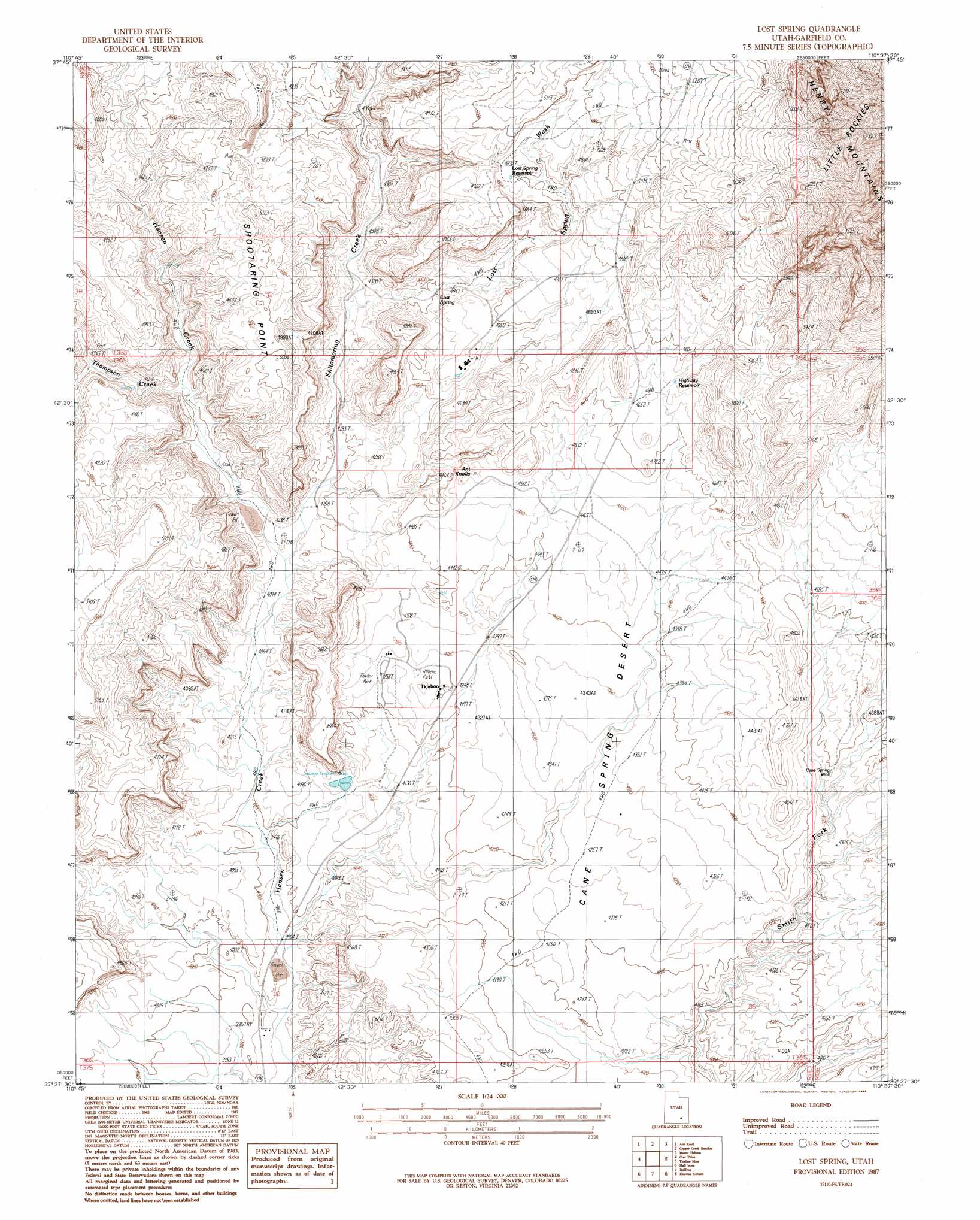
USGS Topo Quad 37110f6 - 1:24,000 scale
| Topo Map Name: | Lost Spring |
| USGS Topo Quad ID: | 37110f6 |
| Print Size: | ca. 21 1/4" wide x 27" high |
| Southeast Coordinates: | 37.625° N latitude / 110.625° W longitude |
| Map Center Coordinates: | 37.6875° N latitude / 110.6875° W longitude |
| U.S. State: | UT |
| Filename: | o37110f6.jpg |
| Download Map JPG Image: | Lost Spring topo map 1:24,000 scale |
| Map Type: | Topographic |
| Topo Series: | 7.5´ |
| Map Scale: | 1:24,000 |
| Source of Map Images: | United States Geological Survey (USGS) |
| Alternate Map Versions: |
Lost Spring UT 1987, updated 1988 Download PDF Buy paper map Lost Spring UT 2011 Download PDF Buy paper map Lost Spring UT 2014 Download PDF Buy paper map |
1:24,000 Topo Quads surrounding Lost Spring
Cave Flat |
Mount Pennell |
Cass Creek Peak |
Black Table |
Hite North |
The Post |
Ant Knoll |
Copper Creek Benches |
Mount Holmes |
Hite South |
Deer Point |
Clay Point |
Lost Spring |
Ticaboo Mesa |
Good Hope Bay |
Stevens Canyon North |
Hall Mesa |
Bullfrog |
Knowles Canyon |
Mancos Mesa |
Stevens Canyon South |
The Rincon Ne |
Halls Crossing |
Halls Crossing Ne |
Burnt Spring |
> Back to 37110e1 at 1:100,000 scale
> Back to 37110a1 at 1:250,000 scale
> Back to U.S. Topo Maps home
Lost Spring topo map: Gazetteer
Lost Spring: Arches
Ant Knolls elevation 1389m 4557′Lost Spring: Plains
Cane Spring Desert elevation 1319m 4327′Lost Spring: Populated Places
Ticaboo elevation 1300m 4265′Lost Spring: Reservoirs
Lost Spring Reservoir elevation 1471m 4826′Poulas Tanks (historical) elevation 1493m 4898′
Lost Spring: Springs
Lost Spring elevation 1354m 4442′Lost Spring: Streams
Lost Spring Wash elevation 1302m 4271′Shitamaring Creek elevation 1254m 4114′
Thompson Creek elevation 1291m 4235′
Lost Spring: Summits
Ant Knolls elevation 1394m 4573′Shootaring Point elevation 1490m 4888′
Lost Spring: Valleys
Lost Spring Wash elevation 1301m 4268′Lost Spring: Wells
Cane Spring Well elevation 1305m 4281′Lost Spring digital topo map on disk
Buy this Lost Spring topo map showing relief, roads, GPS coordinates and other geographical features, as a high-resolution digital map file on DVD: