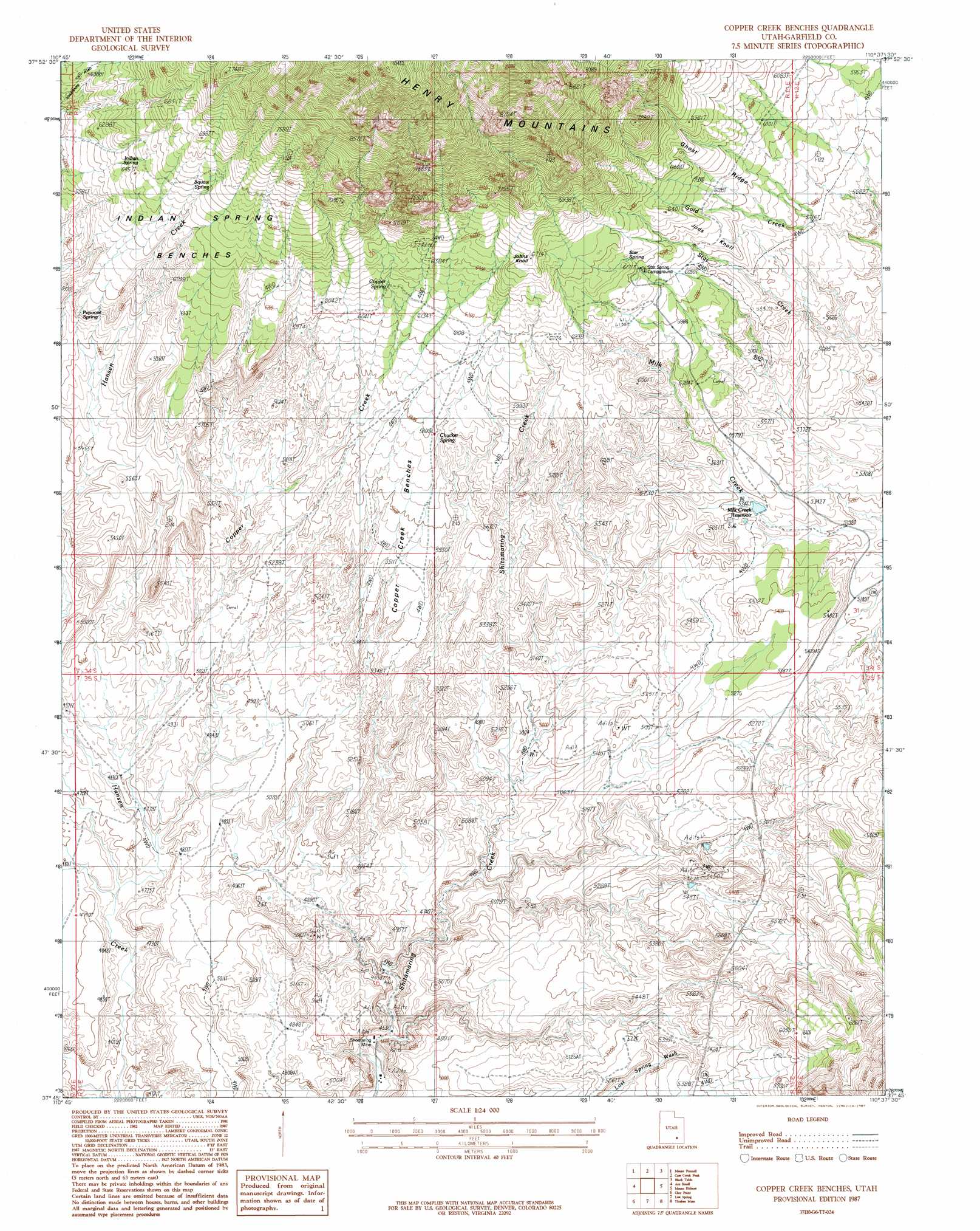
Copper Creek Benches Topo Map Utah
To zoom in, hover over the map of Copper Creek Benches
USGS Topo Quad 37110g6 - 1:24,000 scale
| Topo Map Name: | Copper Creek Benches |
| USGS Topo Quad ID: | 37110g6 |
| Print Size: | ca. 21 1/4" wide x 27" high |
| Southeast Coordinates: | 37.75° N latitude / 110.625° W longitude |
| Map Center Coordinates: | 37.8125° N latitude / 110.6875° W longitude |
| U.S. State: | UT |
| Filename: | o37110g6.jpg |
| Download Map JPG Image: | Copper Creek Benches topo map 1:24,000 scale |
| Map Type: | Topographic |
| Topo Series: | 7.5´ |
| Map Scale: | 1:24,000 |
| Source of Map Images: | United States Geological Survey (USGS) |
| Alternate Map Versions: |
Mt Pennell 1 SW UT 1952, updated 1954 Download PDF Buy paper map Copper Creek Benches UT 1987, updated 1987 Download PDF Buy paper map Copper Creek Benches UT 2011 Download PDF Buy paper map Copper Creek Benches UT 2014 Download PDF Buy paper map |
1:24,000 Topo Quads surrounding Copper Creek Benches
Steele Butte |
Mount Ellen |
Raggy Canyon |
Turkey Knob |
Stair Canyon |
Cave Flat |
Mount Pennell |
Cass Creek Peak |
Black Table |
Hite North |
The Post |
Ant Knoll |
Copper Creek Benches |
Mount Holmes |
Hite South |
Deer Point |
Clay Point |
Lost Spring |
Ticaboo Mesa |
Good Hope Bay |
Stevens Canyon North |
Hall Mesa |
Bullfrog |
Knowles Canyon |
Mancos Mesa |
> Back to 37110e1 at 1:100,000 scale
> Back to 37110a1 at 1:250,000 scale
> Back to U.S. Topo Maps home
Copper Creek Benches topo map: Gazetteer
Copper Creek Benches: Benches
Copper Creek Benches elevation 1726m 5662′Indian Spring Benches elevation 1922m 6305′
Copper Creek Benches: Mines
Del Mont Mine elevation 1584m 5196′Shootaring Mine elevation 1377m 4517′
Copper Creek Benches: Reservoirs
Milk Creek Reservoir elevation 1624m 5328′Copper Creek Benches: Ridges
Ghost Ridge elevation 1902m 6240′Copper Creek Benches: Springs
Chucker Spring elevation 1755m 5757′Copper Spring elevation 1879m 6164′
Indian Spring elevation 1985m 6512′
Papoose Spring elevation 1782m 5846′
Squaw Spring elevation 2033m 6669′
Star Spring elevation 1920m 6299′
Copper Creek Benches: Streams
Copper Creek elevation 1457m 4780′Copper Creek Benches: Summits
Johns Knoll elevation 2041m 6696′Juds Knoll elevation 1942m 6371′
Copper Creek Benches digital topo map on disk
Buy this Copper Creek Benches topo map showing relief, roads, GPS coordinates and other geographical features, as a high-resolution digital map file on DVD: