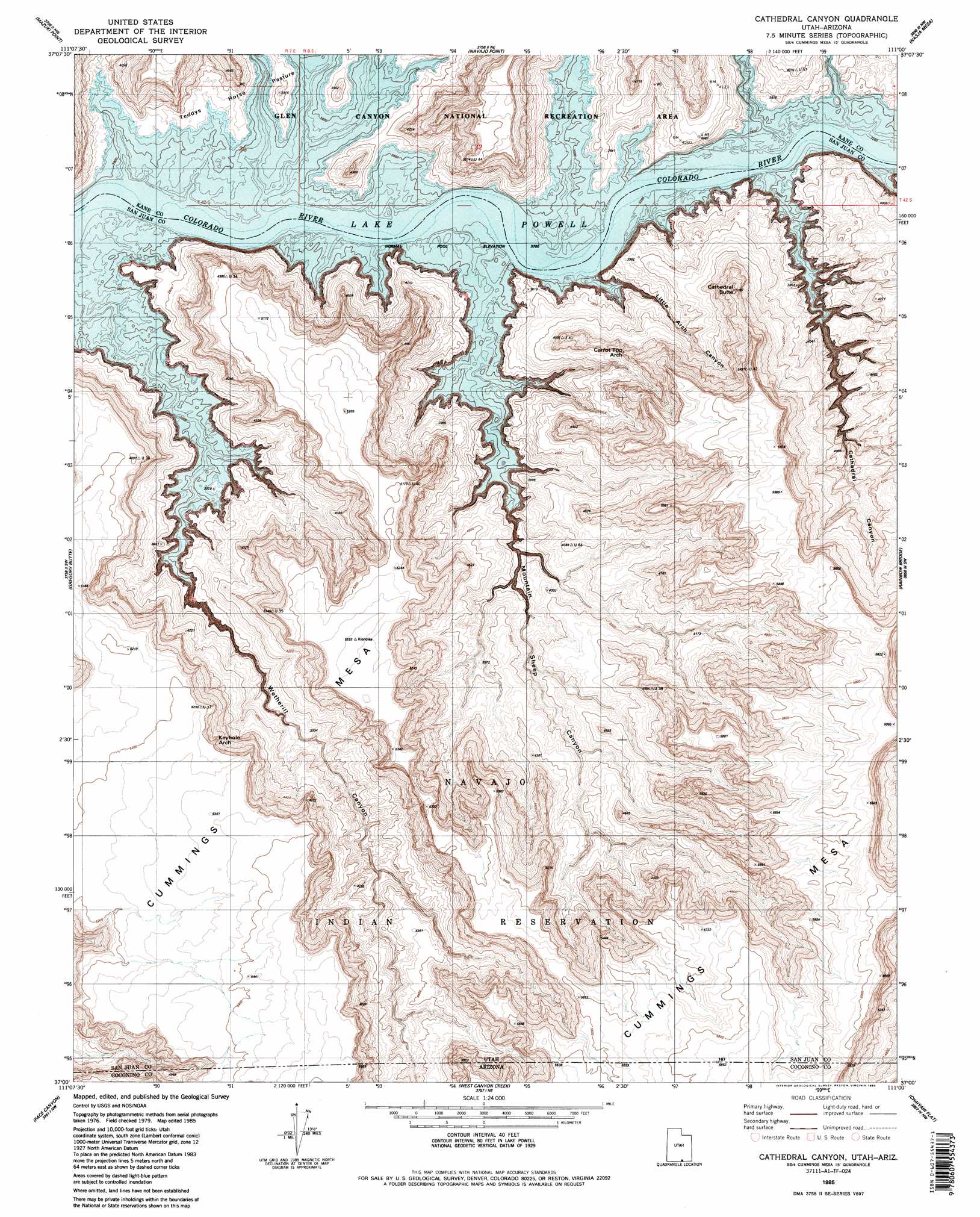
Cathedral Canyon Topo Map Utah
To zoom in, hover over the map of Cathedral Canyon
USGS Topo Quad 37111a1 - 1:24,000 scale
| Topo Map Name: | Cathedral Canyon |
| USGS Topo Quad ID: | 37111a1 |
| Print Size: | ca. 21 1/4" wide x 27" high |
| Southeast Coordinates: | 37° N latitude / 111° W longitude |
| Map Center Coordinates: | 37.0625° N latitude / 111.0625° W longitude |
| U.S. States: | UT, AZ |
| Filename: | o37111a1.jpg |
| Download Map JPG Image: | Cathedral Canyon topo map 1:24,000 scale |
| Map Type: | Topographic |
| Topo Series: | 7.5´ |
| Map Scale: | 1:24,000 |
| Source of Map Images: | United States Geological Survey (USGS) |
| Alternate Map Versions: |
Cathedral Canyon UT 1985, updated 1985 Download PDF Buy paper map Cathedral Canyon UT 1985, updated 1985 Download PDF Buy paper map Cathedral Canyon UT 2011 Download PDF Buy paper map Cathedral Canyon UT 2014 Download PDF Buy paper map |
1:24,000 Topo Quads surrounding Cathedral Canyon
East Of The Navajo |
Blackburn Canyon |
Sooner Bench |
Davis Gulch |
The Rincon |
Sit Down Bench |
Mazuki Point |
Navajo Point |
Nasja Mesa |
Wilson Creek |
Gunsight Butte |
Gregory Butte |
Cathedral Canyon |
Rainbow Bridge |
Navajo Begay |
Wild Horse Mesa |
Face Canyon |
West Canyon Creek |
Chaiyahi Flat |
Chaiyahi Rim Ne |
Leche-E Rock |
Cedar Tree Bench |
Tse Esgizii |
Chaiyahi Rim Sw |
Chaiyahi Rim Se |
> Back to 37111a1 at 1:100,000 scale
> Back to 37110a1 at 1:250,000 scale
> Back to U.S. Topo Maps home
Cathedral Canyon topo map: Gazetteer
Cathedral Canyon: Arches
Carrot Top Arch elevation 1365m 4478′Keyhole Arch elevation 1526m 5006′
Cathedral Canyon: Bars
Klondike Bar elevation 1129m 3704′Klondike Bar (historical) elevation 1129m 3704′
Cathedral Canyon: Summits
Cathedral Butte elevation 1581m 5187′Cummings Mesa elevation 1696m 5564′
Cummings Mesa elevation 1781m 5843′
Cathedral Canyon: Valleys
Cathedral Canyon elevation 1130m 3707′Cornerstone Canyon elevation 1131m 3710′
Little Arch Canyon elevation 1129m 3704′
Mountain Sheep Canyon elevation 1129m 3704′
Wetherill Canyon elevation 1129m 3704′
Wetherill Canyon elevation 1129m 3704′
Cathedral Canyon digital topo map on disk
Buy this Cathedral Canyon topo map showing relief, roads, GPS coordinates and other geographical features, as a high-resolution digital map file on DVD: