Warm Creek Bay Topo Map Utah
To zoom in, hover over the map of Warm Creek Bay
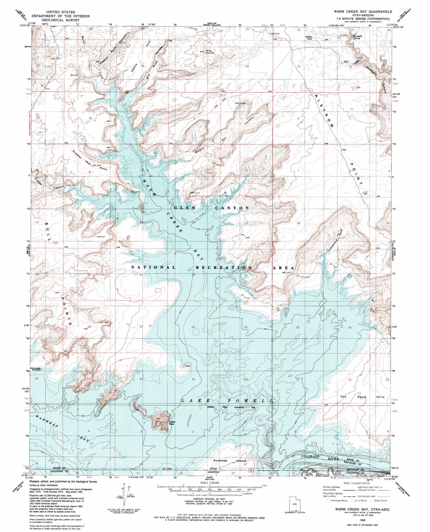
USGS Topo Quad 37111a4 - 1:24,000 scale
| Topo Map Name: | Warm Creek Bay |
| USGS Topo Quad ID: | 37111a4 |
| Print Size: | ca. 21 1/4" wide x 27" high |
| Southeast Coordinates: | 37° N latitude / 111.375° W longitude |
| Map Center Coordinates: | 37.0625° N latitude / 111.4375° W longitude |
| U.S. States: | UT, AZ |
| Filename: | o37111a4.jpg |
| Download Map JPG Image: | Warm Creek Bay topo map 1:24,000 scale |
| Map Type: | Topographic |
| Topo Series: | 7.5´ |
| Map Scale: | 1:24,000 |
| Source of Map Images: | United States Geological Survey (USGS) |
| Alternate Map Versions: |
Warm Creek Bay UT 1985, updated 1985 Download PDF Buy paper map Warm Creek Bay UT 2011 Download PDF Buy paper map Warm Creek Bay UT 2014 Download PDF Buy paper map |
1:24,000 Topo Quads surrounding Warm Creek Bay
Fourmile Bench |
Ship Mountain Point |
Needle Eye Point |
East Of The Navajo |
Blackburn Canyon |
Nipple Butte |
Tibbet Bench |
Smoky Hollow |
Sit Down Bench |
Mazuki Point |
Glen Canyon City |
Lone Rock |
Warm Creek Bay |
Gunsight Butte |
Gregory Butte |
Water Pockets |
Ferry Swale |
Page |
Wild Horse Mesa |
Face Canyon |
Navajo Bridge |
Lees Ferry |
White Dome |
Leche-E Rock |
Cedar Tree Bench |
> Back to 37111a1 at 1:100,000 scale
> Back to 37110a1 at 1:250,000 scale
> Back to U.S. Topo Maps home
Warm Creek Bay topo map: Gazetteer
Warm Creek Bay: Arches
Wahweap Window elevation 1135m 3723′Warm Creek Bay: Bays
Wahweap Bay elevation 1129m 3704′Wahweap Bay elevation 1129m 3704′
Warm Creek Bay elevation 1129m 3704′
Warm Creek Bay: Capes
Pasture Point elevation 1246m 4087′Prickly Pear Point elevation 1242m 4074′
Romana Bench elevation 1378m 4520′
Warm Creek Bay: Pillars
Castle Rock elevation 1309m 4294′Warm Creek Bay: Springs
Dewey Seep elevation 1305m 4281′Gunsight Spring elevation 1320m 4330′
Warm Creek Bay: Streams
Warm Creek elevation 1129m 3704′Warm Creek Bay: Summits
Oley Knolls elevation 1334m 4376′Warm Creek Bay: Valleys
Cottonwood Wash elevation 1129m 3704′Crosby Canyon elevation 1133m 3717′
Pasture Point Canyon elevation 1145m 3756′
Sile Brink Hollow elevation 1136m 3727′
Wagon Box Canyon elevation 1147m 3763′
Warm Creek Bay digital topo map on disk
Buy this Warm Creek Bay topo map showing relief, roads, GPS coordinates and other geographical features, as a high-resolution digital map file on DVD: