Nipple Butte Topo Map Utah
To zoom in, hover over the map of Nipple Butte
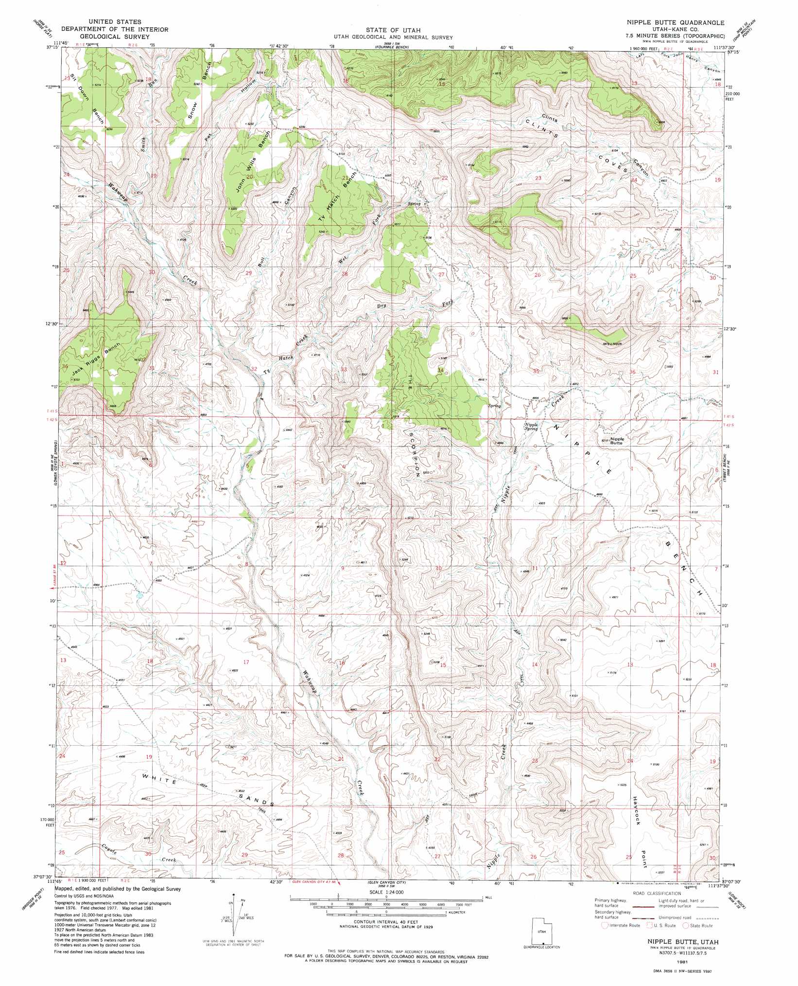
USGS Topo Quad 37111b6 - 1:24,000 scale
| Topo Map Name: | Nipple Butte |
| USGS Topo Quad ID: | 37111b6 |
| Print Size: | ca. 21 1/4" wide x 27" high |
| Southeast Coordinates: | 37.125° N latitude / 111.625° W longitude |
| Map Center Coordinates: | 37.1875° N latitude / 111.6875° W longitude |
| U.S. State: | UT |
| Filename: | o37111b6.jpg |
| Download Map JPG Image: | Nipple Butte topo map 1:24,000 scale |
| Map Type: | Topographic |
| Topo Series: | 7.5´ |
| Map Scale: | 1:24,000 |
| Source of Map Images: | United States Geological Survey (USGS) |
| Alternate Map Versions: |
Nipple Butte UT 1981, updated 1981 Download PDF Buy paper map Nipple Butte UT 2011 Download PDF Buy paper map Nipple Butte UT 2014 Download PDF Buy paper map |
1:24,000 Topo Quads surrounding Nipple Butte
Slickrock Bench |
Butler Valley |
Horse Mountain |
Petes Cove |
Collet Top |
Calico Peak |
Horse Flat |
Fourmile Bench |
Ship Mountain Point |
Needle Eye Point |
Fivemile Valley |
Lower Coyote Spring |
Nipple Butte |
Tibbet Bench |
Smoky Hollow |
West Clark Bench |
Bridger Point |
Glen Canyon City |
Lone Rock |
Warm Creek Bay |
Poverty Flat |
Wrather Arch |
Water Pockets |
Ferry Swale |
Page |
> Back to 37111a1 at 1:100,000 scale
> Back to 37110a1 at 1:250,000 scale
> Back to U.S. Topo Maps home
Nipple Butte topo map: Gazetteer
Nipple Butte: Benches
Jack Riggs Bench elevation 1721m 5646′John Wills Bench elevation 1610m 5282′
Sit Down Bench elevation 1592m 5223′
Snow Bench elevation 1611m 5285′
Ty Hatch Bench elevation 1576m 5170′
Nipple Butte: Flats
White Sands elevation 1375m 4511′Nipple Butte: Gaps
Tworoose Pass elevation 1345m 4412′Nipple Butte: Ridges
Haycock Point elevation 1623m 5324′The Scorpion elevation 1582m 5190′
Nipple Butte: Slopes
Clints Coves elevation 1574m 5164′Nipple Butte: Springs
Nipple Spring elevation 1451m 4760′Nipple Butte: Streams
Bull Canyon elevation 1359m 4458′Dry Fork Ty Hatch Creek elevation 1418m 4652′
Smith Run elevation 1385m 4543′
Ty Hatch Creek elevation 1353m 4438′
Wet Fork Ty Hatch Creek elevation 1418m 4652′
Nipple Butte: Summits
Nipple Butte elevation 1566m 5137′Nipple Butte: Valleys
Long Flat Canyon elevation 1390m 4560′Pet Hollow elevation 1376m 4514′
Nipple Butte digital topo map on disk
Buy this Nipple Butte topo map showing relief, roads, GPS coordinates and other geographical features, as a high-resolution digital map file on DVD: