Lower Coyote Spring Topo Map Utah
To zoom in, hover over the map of Lower Coyote Spring
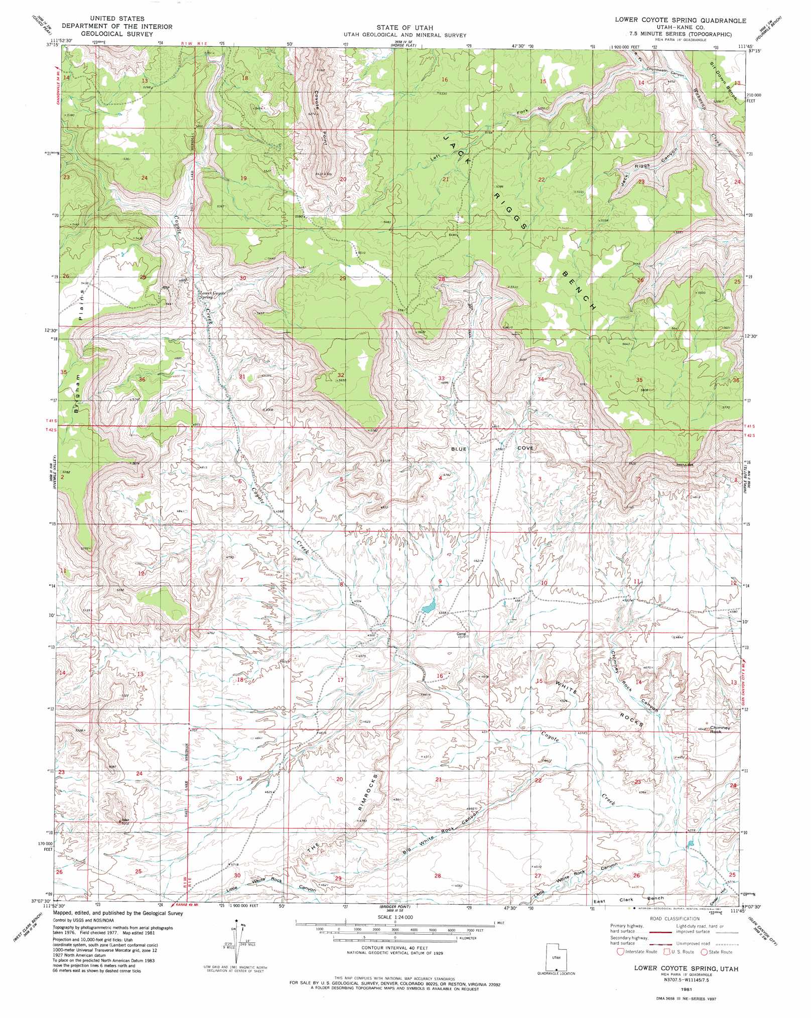
USGS Topo Quad 37111b7 - 1:24,000 scale
| Topo Map Name: | Lower Coyote Spring |
| USGS Topo Quad ID: | 37111b7 |
| Print Size: | ca. 21 1/4" wide x 27" high |
| Southeast Coordinates: | 37.125° N latitude / 111.75° W longitude |
| Map Center Coordinates: | 37.1875° N latitude / 111.8125° W longitude |
| U.S. State: | UT |
| Filename: | o37111b7.jpg |
| Download Map JPG Image: | Lower Coyote Spring topo map 1:24,000 scale |
| Map Type: | Topographic |
| Topo Series: | 7.5´ |
| Map Scale: | 1:24,000 |
| Source of Map Images: | United States Geological Survey (USGS) |
| Alternate Map Versions: |
Lower Coyote Spring UT 1981, updated 1981 Download PDF Buy paper map Lower Coyote Spring UT 2011 Download PDF Buy paper map Lower Coyote Spring UT 2014 Download PDF Buy paper map |
1:24,000 Topo Quads surrounding Lower Coyote Spring
Bull Valley Gorge |
Slickrock Bench |
Butler Valley |
Horse Mountain |
Petes Cove |
Deer Range Point |
Calico Peak |
Horse Flat |
Fourmile Bench |
Ship Mountain Point |
Eightmile Pass |
Fivemile Valley |
Lower Coyote Spring |
Nipple Butte |
Tibbet Bench |
Pine Hollow Canyon |
West Clark Bench |
Bridger Point |
Glen Canyon City |
Lone Rock |
Coyote Buttes |
Poverty Flat |
Wrather Arch |
Water Pockets |
Ferry Swale |
> Back to 37111a1 at 1:100,000 scale
> Back to 37110a1 at 1:250,000 scale
> Back to U.S. Topo Maps home
Lower Coyote Spring topo map: Gazetteer
Lower Coyote Spring: Areas
White Rocks elevation 1381m 4530′Lower Coyote Spring: Benches
Jack Riggs Bench elevation 1667m 5469′Lower Coyote Spring: Pillars
Chimney Rock elevation 1384m 4540′Lower Coyote Spring: Ridges
Coyote Point elevation 1882m 6174′Lower Coyote Spring: Springs
Lower Coyote Spring elevation 1451m 4760′Lower Coyote Spring: Valleys
Big White Rock Canyon elevation 1320m 4330′Blue Cove elevation 1453m 4767′
Cedar Hollow elevation 1289m 4229′
Chimney Rock Canyon elevation 1300m 4265′
Chynoweth Canyon elevation 1421m 4662′
Jack Riggs Canyon elevation 1409m 4622′
Little White Rock Canyon elevation 1302m 4271′
Right Fork Chynoweth Canyon elevation 1423m 4668′
Lower Coyote Spring digital topo map on disk
Buy this Lower Coyote Spring topo map showing relief, roads, GPS coordinates and other geographical features, as a high-resolution digital map file on DVD: