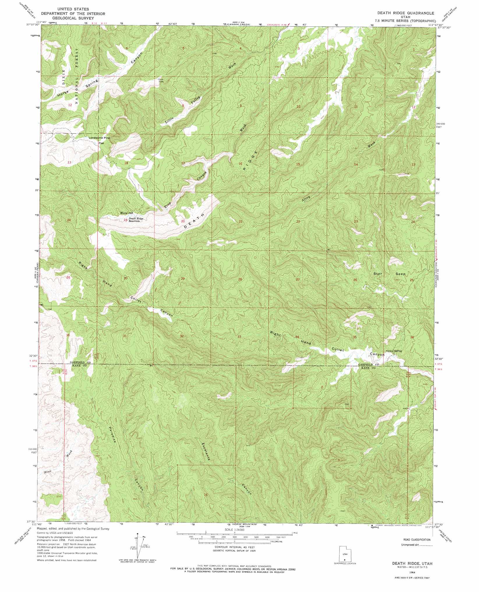
Death Ridge Topo Map Utah
To zoom in, hover over the map of Death Ridge
USGS Topo Quad 37111e6 - 1:24,000 scale
| Topo Map Name: | Death Ridge |
| USGS Topo Quad ID: | 37111e6 |
| Print Size: | ca. 21 1/4" wide x 27" high |
| Southeast Coordinates: | 37.5° N latitude / 111.625° W longitude |
| Map Center Coordinates: | 37.5625° N latitude / 111.6875° W longitude |
| U.S. State: | UT |
| Filename: | o37111e6.jpg |
| Download Map JPG Image: | Death Ridge topo map 1:24,000 scale |
| Map Type: | Topographic |
| Topo Series: | 7.5´ |
| Map Scale: | 1:24,000 |
| Source of Map Images: | United States Geological Survey (USGS) |
| Alternate Map Versions: |
Death Ridge UT 1964, updated 1966 Download PDF Buy paper map Death Ridge UT 1964, updated 1975 Download PDF Buy paper map Death Ridge UT 2002, updated 2005 Download PDF Buy paper map Death Ridge UT 2011 Download PDF Buy paper map Death Ridge UT 2014 Download PDF Buy paper map |
| FStopo: | US Forest Service topo Death Ridge is available: Download FStopo PDF Download FStopo TIF |
1:24,000 Topo Quads surrounding Death Ridge
Sweetwater Creek |
Griffin Point |
Wide Hollow Reservoir |
Escalante |
Calf Creek |
Pine Lake |
Upper Valley |
Canaan Creek |
Dave Canyon |
Tenmile Flat |
Henrieville |
Canaan Peak |
Death Ridge |
Carcass Canyon |
Seep Flat |
Slickrock Bench |
Butler Valley |
Horse Mountain |
Petes Cove |
Collet Top |
Calico Peak |
Horse Flat |
Fourmile Bench |
Ship Mountain Point |
Needle Eye Point |
> Back to 37111e1 at 1:100,000 scale
> Back to 37110a1 at 1:250,000 scale
> Back to U.S. Topo Maps home
Death Ridge topo map: Gazetteer
Death Ridge: Areas
Star Seep elevation 2014m 6607′Death Ridge: Basins
Mossy Dell elevation 2178m 7145′Death Ridge: Flats
Lonesome Pine Flat elevation 2299m 7542′Death Ridge: Reservoirs
Death Ridge Reservoir elevation 2170m 7119′Death Ridge: Ridges
Death Ridge elevation 2369m 7772′Death Ridge: Springs
Camp Spring elevation 1889m 6197′Mossy Dell Spring elevation 2170m 7119′
Death Ridge digital topo map on disk
Buy this Death Ridge topo map showing relief, roads, GPS coordinates and other geographical features, as a high-resolution digital map file on DVD: