Tenmile Flat Topo Map Utah
To zoom in, hover over the map of Tenmile Flat
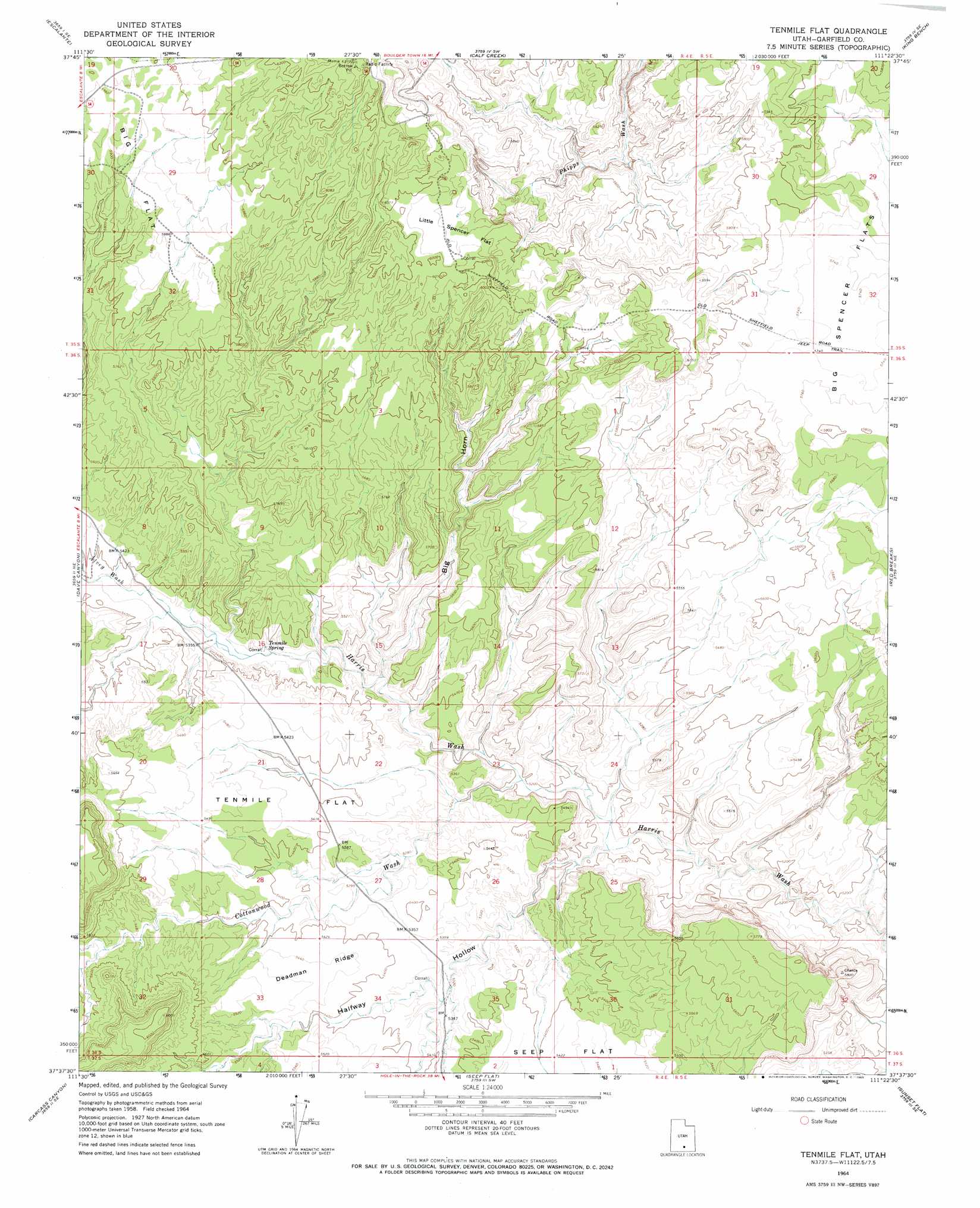
USGS Topo Quad 37111f4 - 1:24,000 scale
| Topo Map Name: | Tenmile Flat |
| USGS Topo Quad ID: | 37111f4 |
| Print Size: | ca. 21 1/4" wide x 27" high |
| Southeast Coordinates: | 37.625° N latitude / 111.375° W longitude |
| Map Center Coordinates: | 37.6875° N latitude / 111.4375° W longitude |
| U.S. State: | UT |
| Filename: | o37111f4.jpg |
| Download Map JPG Image: | Tenmile Flat topo map 1:24,000 scale |
| Map Type: | Topographic |
| Topo Series: | 7.5´ |
| Map Scale: | 1:24,000 |
| Source of Map Images: | United States Geological Survey (USGS) |
| Alternate Map Versions: |
Tenmile Flat UT 1964, updated 1965 Download PDF Buy paper map Tenmile Flat UT 1964, updated 1965 Download PDF Buy paper map Tenmile Flat UT 1964, updated 1965 Download PDF Buy paper map Tenmile Flat UT 2011 Download PDF Buy paper map Tenmile Flat UT 2014 Download PDF Buy paper map |
1:24,000 Topo Quads surrounding Tenmile Flat
Posy Lake |
Roger Peak |
Boulder Town |
Steep Creek Bench |
Lamp Stand |
Wide Hollow Reservoir |
Escalante |
Calf Creek |
King Bench |
Pioneer Mesa |
Canaan Creek |
Dave Canyon |
Tenmile Flat |
Red Breaks |
Silver Falls Bench |
Death Ridge |
Carcass Canyon |
Seep Flat |
Sunset Flat |
Egypt |
Horse Mountain |
Petes Cove |
Collet Top |
Basin Canyon |
Big Hollow Wash |
> Back to 37111e1 at 1:100,000 scale
> Back to 37110a1 at 1:250,000 scale
> Back to U.S. Topo Maps home
Tenmile Flat topo map: Gazetteer
Tenmile Flat: Flats
Big Spencer Flats elevation 1751m 5744′Little Spencer Flat elevation 1805m 5921′
Tenmile Flat elevation 1649m 5410′
Tenmile Flat: Ridges
Deadman Ridge elevation 1662m 5452′Tenmile Flat: Springs
Tenmile Spring elevation 1621m 5318′Tenmile Flat: Valleys
Alvey Wash elevation 1625m 5331′Big Horn elevation 1597m 5239′
Cottonwood Wash elevation 1580m 5183′
Halfway Hollow elevation 1568m 5144′
Tenmile Flat digital topo map on disk
Buy this Tenmile Flat topo map showing relief, roads, GPS coordinates and other geographical features, as a high-resolution digital map file on DVD: