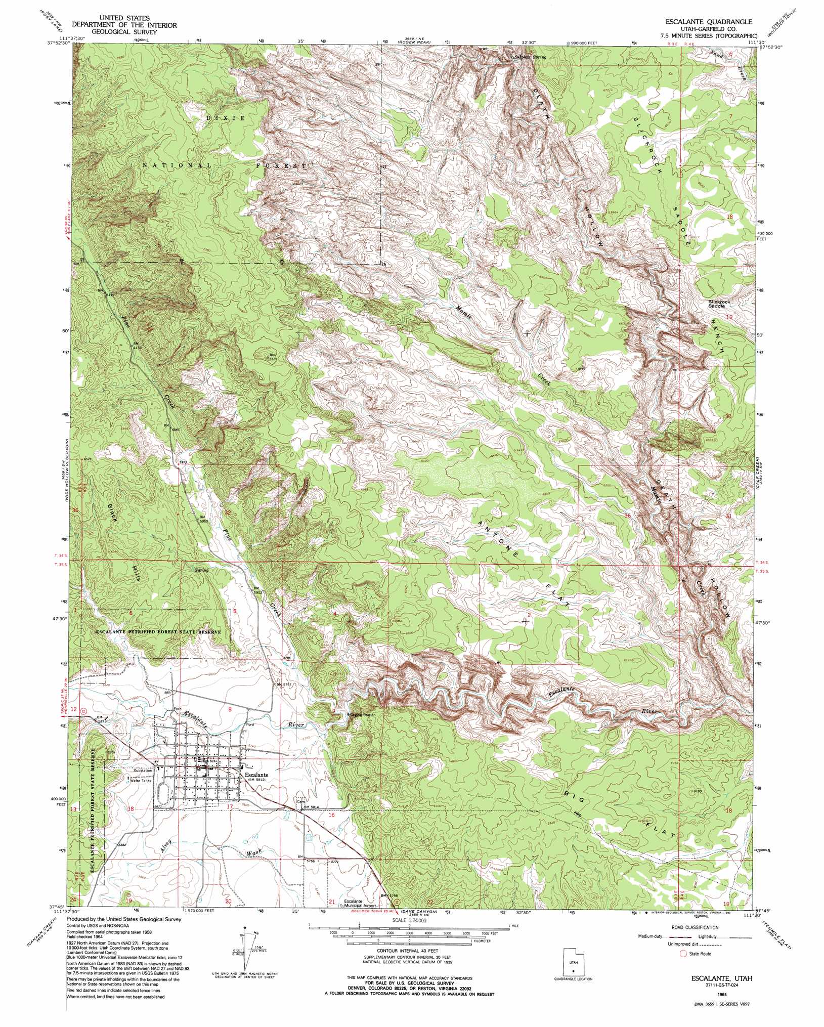
Escalante Topo Map Utah
To zoom in, hover over the map of Escalante
USGS Topo Quad 37111g5 - 1:24,000 scale
| Topo Map Name: | Escalante |
| USGS Topo Quad ID: | 37111g5 |
| Print Size: | ca. 21 1/4" wide x 27" high |
| Southeast Coordinates: | 37.75° N latitude / 111.5° W longitude |
| Map Center Coordinates: | 37.8125° N latitude / 111.5625° W longitude |
| U.S. State: | UT |
| Filename: | o37111g5.jpg |
| Download Map JPG Image: | Escalante topo map 1:24,000 scale |
| Map Type: | Topographic |
| Topo Series: | 7.5´ |
| Map Scale: | 1:24,000 |
| Source of Map Images: | United States Geological Survey (USGS) |
| Alternate Map Versions: |
Escalante UT 1964, updated 1983 Download PDF Buy paper map Escalante UT 1964, updated 1993 Download PDF Buy paper map Escalante UT 2002, updated 2005 Download PDF Buy paper map Escalante UT 2011 Download PDF Buy paper map Escalante UT 2014 Download PDF Buy paper map |
| FStopo: | US Forest Service topo Escalante is available: Download FStopo PDF Download FStopo TIF |
1:24,000 Topo Quads surrounding Escalante
Pollywog Lake |
Big Lake |
Jacobs Reservoir |
Deer Creek Lake |
Lower Bowns Reservoir |
Barker Reservoir |
Posy Lake |
Roger Peak |
Boulder Town |
Steep Creek Bench |
Griffin Point |
Wide Hollow Reservoir |
Escalante |
Calf Creek |
King Bench |
Upper Valley |
Canaan Creek |
Dave Canyon |
Tenmile Flat |
Red Breaks |
Canaan Peak |
Death Ridge |
Carcass Canyon |
Seep Flat |
Sunset Flat |
> Back to 37111e1 at 1:100,000 scale
> Back to 37110a1 at 1:250,000 scale
> Back to U.S. Topo Maps home
Escalante topo map: Gazetteer
Escalante: Areas
Phipps-Death Hollow Outstanding Natural Area elevation 1980m 6496′Escalante: Basins
Potato Valley elevation 1775m 5823′Escalante: Benches
Slickrock Saddle Bench elevation 2015m 6610′Escalante: Flats
Antone Flat elevation 1964m 6443′Big Flat elevation 1900m 6233′
Escalante: Gaps
Slickrock Saddle elevation 1968m 6456′Escalante: Populated Places
Escalante elevation 1774m 5820′Escalante: Springs
Sulphur Spring elevation 1878m 6161′Escalante: Streams
Mamie Creek elevation 1643m 5390′Pine Creek elevation 1728m 5669′
Escalante: Trails
Boulder Mail Trail elevation 1946m 6384′Hole-in-the-Rock Road elevation 1772m 5813′
Escalante: Valleys
Death Hollow elevation 1643m 5390′Escalante digital topo map on disk
Buy this Escalante topo map showing relief, roads, GPS coordinates and other geographical features, as a high-resolution digital map file on DVD: