Kanab Topo Map Utah
To zoom in, hover over the map of Kanab
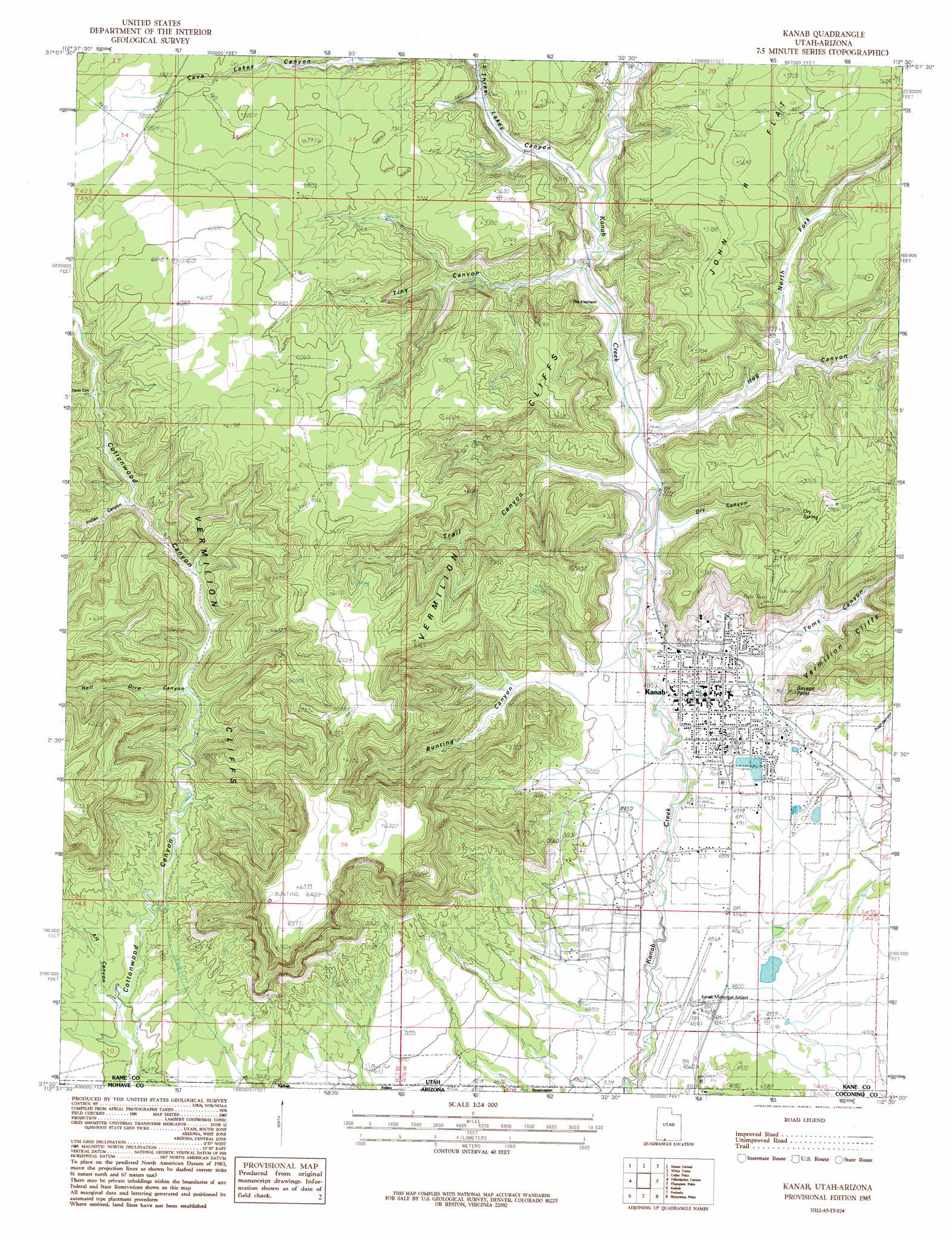
USGS Topo Quad 37112a5 - 1:24,000 scale
| Topo Map Name: | Kanab |
| USGS Topo Quad ID: | 37112a5 |
| Print Size: | ca. 21 1/4" wide x 27" high |
| Southeast Coordinates: | 37° N latitude / 112.5° W longitude |
| Map Center Coordinates: | 37.0625° N latitude / 112.5625° W longitude |
| U.S. States: | UT, AZ |
| Filename: | o37112a5.jpg |
| Download Map JPG Image: | Kanab topo map 1:24,000 scale |
| Map Type: | Topographic |
| Topo Series: | 7.5´ |
| Map Scale: | 1:24,000 |
| Source of Map Images: | United States Geological Survey (USGS) |
| Alternate Map Versions: |
Kanab SE UT 1954, updated 1956 Download PDF Buy paper map Kanab UT 1985, updated 1985 Download PDF Buy paper map Kanab UT 1985, updated 1985 Download PDF Buy paper map Kanab UT 2011 Download PDF Buy paper map Kanab UT 2014 Download PDF Buy paper map |
1:24,000 Topo Quads surrounding Kanab
Clear Creek Mountain |
Orderville |
Glendale |
Bald Knoll |
Skutumpah Creek |
The Barracks |
Mount Carmel |
White Tower |
Cutler Point |
Pine Point |
Elephant Butte |
Yellowjacket Canyon |
Kanab |
Thompson Point |
Johnson Lakes |
Moccasin |
Kaibab |
Fredonia |
Shinarump Point |
Muggins Flat |
Pipe Valley |
Pipe Spring |
Clear Water Spring |
White Sage Flat |
Le Fevre Ridge |
> Back to 37112a1 at 1:100,000 scale
> Back to 37112a1 at 1:250,000 scale
> Back to U.S. Topo Maps home
Kanab topo map: Gazetteer
Kanab: Airports
Kanab Municipal Airport elevation 1472m 4829′Kanab: Capes
Savage Point elevation 1781m 5843′Kanab: Dams
Spencer Number Two Dam elevation 1480m 4855′Kanab: Parks
Littles Campground and RV Park elevation 1506m 4940′Kanab: Populated Places
Kanab elevation 1515m 4970′Kanab: Post Offices
Kanab Post Office elevation 1477m 4845′Kanab: Reservoirs
Spencer Number Two Reservoir elevation 1480m 4855′Kanab: Springs
Dry Spring elevation 1705m 5593′Kanab: Summits
Cottonwood Point elevation 1592m 5223′Indian Dance Hall elevation 1684m 5524′
Kanab: Valleys
Art Canyon elevation 1525m 5003′Bunting Canyon elevation 1525m 5003′
Cave Lakes Canyon elevation 1672m 5485′
Cottonwood Canyon elevation 1531m 5022′
Dry Canyon elevation 1536m 5039′
Farm Canyon elevation 1706m 5597′
Hog Canyon elevation 1538m 5045′
Indian Canyon elevation 1668m 5472′
North Fork Hog Canyon elevation 1566m 5137′
Pugh Canyon elevation 1522m 4993′
Three Lakes Canyon elevation 1547m 5075′
Tiny Canyon elevation 1560m 5118′
Toms Canyon elevation 1525m 5003′
Trail Canyon elevation 1512m 4960′
Kanab digital topo map on disk
Buy this Kanab topo map showing relief, roads, GPS coordinates and other geographical features, as a high-resolution digital map file on DVD: