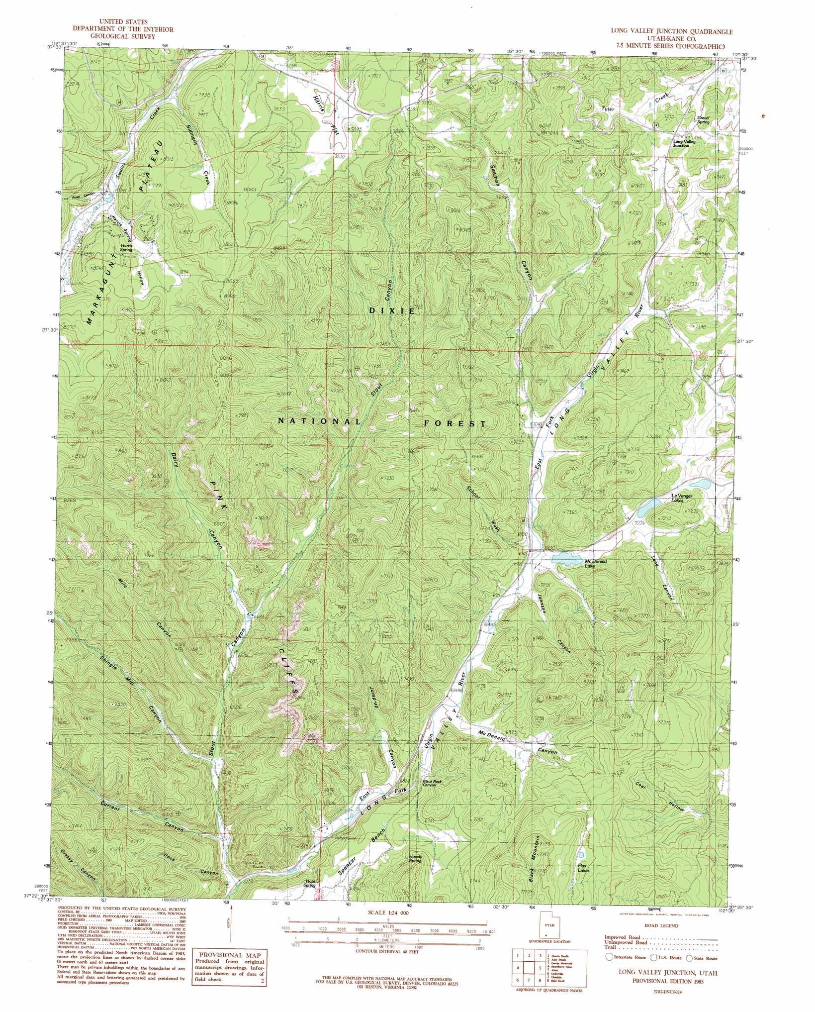
Long Valley Junction Topo Map Utah
To zoom in, hover over the map of Long Valley Junction
USGS Topo Quad 37112d5 - 1:24,000 scale
| Topo Map Name: | Long Valley Junction |
| USGS Topo Quad ID: | 37112d5 |
| Print Size: | ca. 21 1/4" wide x 27" high |
| Southeast Coordinates: | 37.375° N latitude / 112.5° W longitude |
| Map Center Coordinates: | 37.4375° N latitude / 112.5625° W longitude |
| U.S. State: | UT |
| Filename: | o37112d5.jpg |
| Download Map JPG Image: | Long Valley Junction topo map 1:24,000 scale |
| Map Type: | Topographic |
| Topo Series: | 7.5´ |
| Map Scale: | 1:24,000 |
| Source of Map Images: | United States Geological Survey (USGS) |
| Alternate Map Versions: |
Long Valley Junction UT 1985, updated 1985 Download PDF Buy paper map Long Valley Junction UT 2002, updated 2005 Download PDF Buy paper map Long Valley Junction UT 2011 Download PDF Buy paper map Long Valley Junction UT 2014 Download PDF Buy paper map |
| FStopo: | US Forest Service topo Long Valley Junction is available: Download FStopo PDF Download FStopo TIF |
1:24,000 Topo Quads surrounding Long Valley Junction
Brian Head |
Panguitch Lake |
Haycock Mountain |
Hatch |
Wilson Peak |
Navajo Lake |
Henrie Knolls |
Asay Bench |
George Mountain |
Tropic Reservoir |
Straight Canyon |
Strawberry Point |
Long Valley Junction |
Alton |
Podunk Creek |
Clear Creek Mountain |
Orderville |
Glendale |
Bald Knoll |
Skutumpah Creek |
The Barracks |
Mount Carmel |
White Tower |
Cutler Point |
Pine Point |
> Back to 37112a1 at 1:100,000 scale
> Back to 37112a1 at 1:250,000 scale
> Back to U.S. Topo Maps home
Long Valley Junction topo map: Gazetteer
Long Valley Junction: Airports
Swains Creek Airport elevation 2365m 7759′Long Valley Junction: Benches
Spencer Bench elevation 2049m 6722′Long Valley Junction: Flats
Harris Flat elevation 2379m 7805′Long Valley Junction: Gaps
Gravel Pass elevation 2281m 7483′Long Valley Junction: Lakes
Flax Lakes elevation 2268m 7440′Le Vanger Lakes elevation 2197m 7208′
Long Valley Junction: Populated Places
Long Valley Junction elevation 2275m 7463′Long Valley Junction: Reservoirs
McDonald Lake elevation 2117m 6945′Long Valley Junction: Springs
Gravel Spring elevation 2261m 7417′Harris Spring elevation 2392m 7847′
Hops Spring elevation 2061m 6761′
Howdy Spring elevation 2114m 6935′
Jolly Spring elevation 2172m 7125′
Long Valley Junction: Streams
Billingsly Creek elevation 2339m 7673′Minnie Creek elevation 2239m 7345′
Tyler Creek elevation 2239m 7345′
Long Valley Junction: Summits
Black Mountain elevation 2363m 7752′Long Valley Junction: Valleys
Birch Canyon elevation 2185m 7168′Black Rock Canyon elevation 2055m 6742′
Currant Canyon elevation 1938m 6358′
Dairy Canyon elevation 2044m 6706′
Dons Canyon elevation 1943m 6374′
Harris Spring Hollow elevation 2366m 7762′
Johnson Canyon elevation 2115m 6938′
Jump-Up Canyon elevation 2016m 6614′
Long Canyon elevation 2155m 7070′
McDonald Canyon elevation 2088m 6850′
Mile Canyon elevation 2001m 6564′
Road Canyon elevation 2369m 7772′
School Wash elevation 2121m 6958′
Seaman Canyon elevation 2147m 7043′
Shingle Mill Canyon elevation 1968m 6456′
Stout Canyon elevation 1906m 6253′
Long Valley Junction digital topo map on disk
Buy this Long Valley Junction topo map showing relief, roads, GPS coordinates and other geographical features, as a high-resolution digital map file on DVD: