Bryce Point Topo Map Utah
To zoom in, hover over the map of Bryce Point
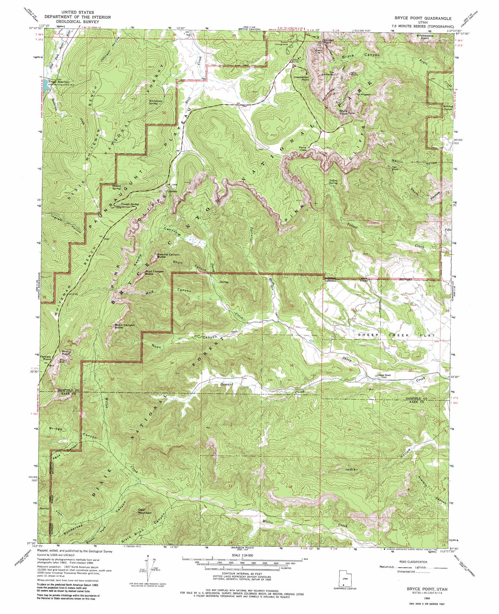
USGS Topo Quad 37112e2 - 1:24,000 scale
| Topo Map Name: | Bryce Point |
| USGS Topo Quad ID: | 37112e2 |
| Print Size: | ca. 21 1/4" wide x 27" high |
| Southeast Coordinates: | 37.5° N latitude / 112.125° W longitude |
| Map Center Coordinates: | 37.5625° N latitude / 112.1875° W longitude |
| U.S. State: | UT |
| Filename: | o37112e2.jpg |
| Download Map JPG Image: | Bryce Point topo map 1:24,000 scale |
| Map Type: | Topographic |
| Topo Series: | 7.5´ |
| Map Scale: | 1:24,000 |
| Source of Map Images: | United States Geological Survey (USGS) |
| Alternate Map Versions: |
Bryce Point UT 1966, updated 1969 Download PDF Buy paper map Bryce Point UT 1966, updated 1982 Download PDF Buy paper map Bryce Point UT 2002, updated 2005 Download PDF Buy paper map Bryce Point UT 2011 Download PDF Buy paper map Bryce Point UT 2014 Download PDF Buy paper map |
| FStopo: | US Forest Service topo Bryce Point is available: Download FStopo PDF Download FStopo TIF |
1:24,000 Topo Quads surrounding Bryce Point
Panguitch |
Casto Canyon |
Flake Mountain West |
Flake Mountain East |
Sweetwater Creek |
Hatch |
Wilson Peak |
Bryce Canyon |
Tropic Canyon |
Pine Lake |
George Mountain |
Tropic Reservoir |
Bryce Point |
Cannonville |
Henrieville |
Alton |
Podunk Creek |
Rainbow Point |
Bull Valley Gorge |
Slickrock Bench |
Bald Knoll |
Skutumpah Creek |
Deer Spring Point |
Deer Range Point |
Calico Peak |
> Back to 37112e1 at 1:100,000 scale
> Back to 37112a1 at 1:250,000 scale
> Back to U.S. Topo Maps home
Bryce Point topo map: Gazetteer
Bryce Point: Arches
Fairview Natural Bridge elevation 2603m 8540′Two Bridges elevation 2230m 7316′
Bryce Point: Areas
Queens Garden elevation 2324m 7624′Bryce Point: Benches
Whiteman Bench elevation 2617m 8585′Bryce Point: Capes
Bryce Point elevation 2531m 8303′Inspiration Point elevation 2506m 8221′
Bryce Point: Cliffs
Farview Point elevation 2689m 8822′Hindu Temples elevation 2377m 7798′
Liberty Castle elevation 2494m 8182′
Piracy Point elevation 2664m 8740′
Sunset Point elevation 2412m 7913′
Bryce Point: Flats
Sheep Creek Flat elevation 1965m 6446′Bryce Point: Parks
Bryce Canyon National Park elevation 2492m 8175′Bryce Point: Pillars
Alley Oop and Dinny elevation 2348m 7703′Carmel and Wiseman elevation 2304m 7559′
Fairy Castle elevation 2379m 7805′
Gullivers Castle elevation 2315m 7595′
Hat Shop elevation 2250m 7381′
Joseph and Mary elevation 2337m 7667′
Katzenjammer Kids elevation 2342m 7683′
Mutt and Jeff elevation 2330m 7644′
Organ Grinders Monkey elevation 2339m 7673′
Pagoda elevation 2330m 7644′
Pans Pinnacle elevation 2330m 7644′
Queen Victoria elevation 2318m 7604′
Silent City elevation 2359m 7739′
Temple of Osiris elevation 2339m 7673′
Temples of the Gods elevation 2330m 7644′
The Alligator elevation 2399m 7870′
The Gossips elevation 2315m 7595′
The Pope elevation 2267m 7437′
The Sentinel elevation 2390m 7841′
Thors Hammer elevation 2367m 7765′
Three Wiseman elevation 2369m 7772′
Turtle elevation 2322m 7618′
Wall of Windows elevation 2491m 8172′
Wall Street elevation 2295m 7529′
Bryce Point: Reservoirs
Tropic Reservoir elevation 2391m 7844′Bryce Point: Springs
Shaker Spring elevation 2573m 8441′Trough Spring elevation 2539m 8330′
Whiteman Spring elevation 2454m 8051′
Yellow Spring elevation 2202m 7224′
Bryce Point: Streams
Bridge Creek elevation 2229m 7312′Henderson Creek elevation 2391m 7844′
Heward Creek elevation 2001m 6564′
Bryce Point: Summits
Bristlecone Point elevation 2358m 7736′Deer Mountain elevation 2382m 7814′
Mud Canyon Butte elevation 2501m 8205′
Noon Canyon Butte elevation 2567m 8421′
Swamp Canyon Butte elevation 2524m 8280′
The Cathedral elevation 2315m 7595′
Bryce Point: Trails
Horse Trail elevation 2332m 7650′Navajo Loop Trail elevation 2279m 7477′
Peekaboo Loop Trail elevation 2290m 7513′
Queens Garden Trail elevation 2260m 7414′
Sheep Creek Connecting Trail elevation 2253m 7391′
Swamp Canyon Connecting Trail elevation 2334m 7657′
Under-the-Rim Trail elevation 2389m 7837′
Whiteman Connecting Trail elevation 2533m 8310′
Bryce Point: Valleys
Agua Canyon elevation 2341m 7680′Black Birch Canyon elevation 2123m 6965′
Bridge Canyon elevation 2243m 7358′
Bryce Canyon elevation 2164m 7099′
Mud Canyon elevation 2146m 7040′
Noon Canyon elevation 2086m 6843′
North Fork Ponderosa Canyon elevation 2293m 7522′
North Hall elevation 2260m 7414′
Pasture Wash elevation 2085m 6840′
Peekaboo Canyon elevation 2241m 7352′
Ponderosa Canyon elevation 2167m 7109′
Short Canyon elevation 2179m 7148′
South Fork Ponderosa Canyon elevation 2219m 7280′
South Hall elevation 2284m 7493′
Swamp Canyon elevation 2207m 7240′
Bryce Point digital topo map on disk
Buy this Bryce Point topo map showing relief, roads, GPS coordinates and other geographical features, as a high-resolution digital map file on DVD: