Tropic Canyon Topo Map Utah
To zoom in, hover over the map of Tropic Canyon
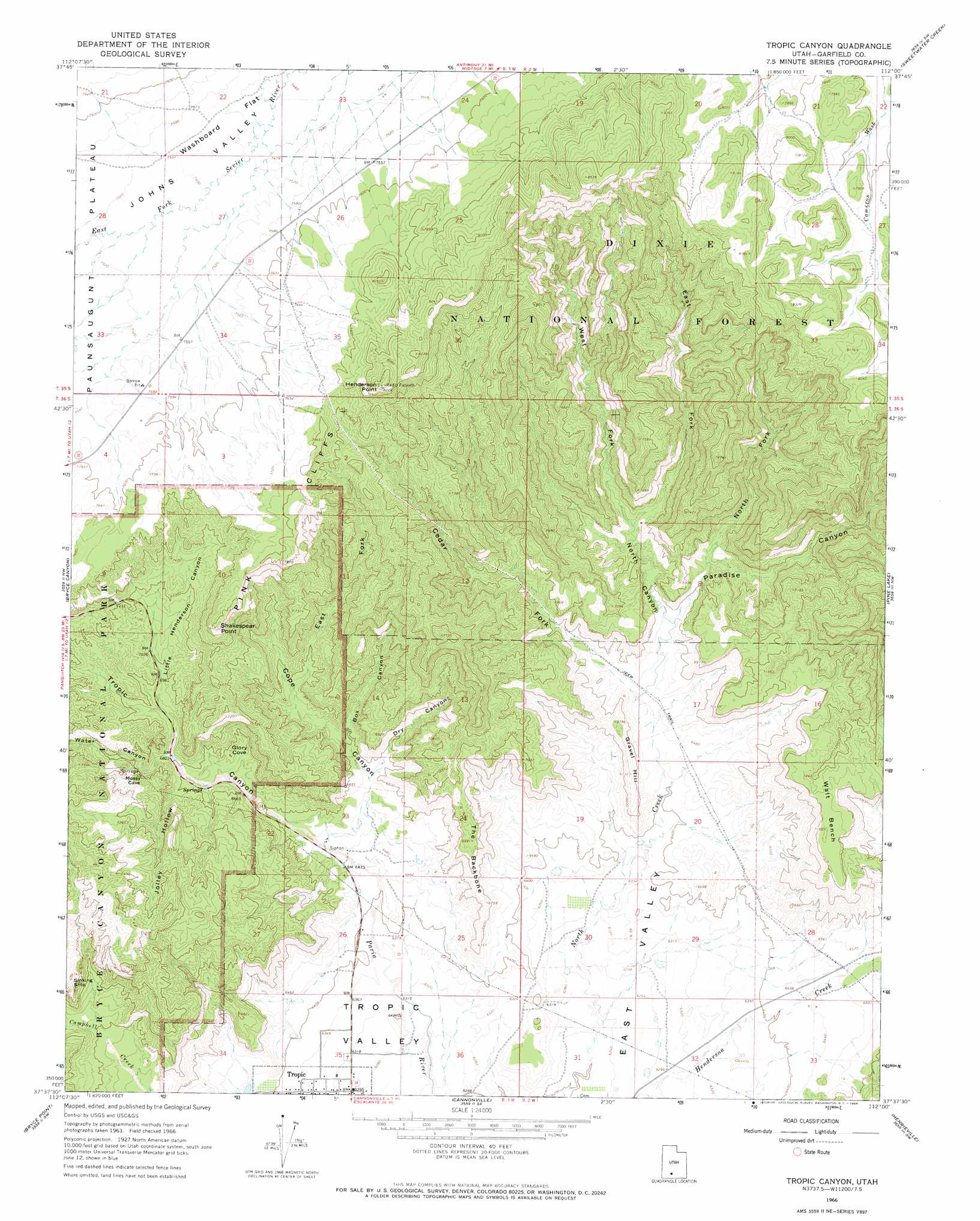
USGS Topo Quad 37112f1 - 1:24,000 scale
| Topo Map Name: | Tropic Canyon |
| USGS Topo Quad ID: | 37112f1 |
| Print Size: | ca. 21 1/4" wide x 27" high |
| Southeast Coordinates: | 37.625° N latitude / 112° W longitude |
| Map Center Coordinates: | 37.6875° N latitude / 112.0625° W longitude |
| U.S. State: | UT |
| Filename: | o37112f1.jpg |
| Download Map JPG Image: | Tropic Canyon topo map 1:24,000 scale |
| Map Type: | Topographic |
| Topo Series: | 7.5´ |
| Map Scale: | 1:24,000 |
| Source of Map Images: | United States Geological Survey (USGS) |
| Alternate Map Versions: |
Tropic Canyon UT 1966, updated 1968 Download PDF Buy paper map Tropic Canyon UT 2002, updated 2005 Download PDF Buy paper map Tropic Canyon UT 2011 Download PDF Buy paper map Tropic Canyon UT 2014 Download PDF Buy paper map |
| FStopo: | US Forest Service topo Tropic Canyon is available: Download FStopo PDF Download FStopo TIF |
1:24,000 Topo Quads surrounding Tropic Canyon
Blind Spring Mountain |
Adams Head |
Cow Creek |
Grass Lakes |
Barker Reservoir |
Casto Canyon |
Flake Mountain West |
Flake Mountain East |
Sweetwater Creek |
Griffin Point |
Wilson Peak |
Bryce Canyon |
Tropic Canyon |
Pine Lake |
Upper Valley |
Tropic Reservoir |
Bryce Point |
Cannonville |
Henrieville |
Canaan Peak |
Podunk Creek |
Rainbow Point |
Bull Valley Gorge |
Slickrock Bench |
Butler Valley |
> Back to 37112e1 at 1:100,000 scale
> Back to 37112a1 at 1:250,000 scale
> Back to U.S. Topo Maps home
Tropic Canyon topo map: Gazetteer
Tropic Canyon: Basins
Tropic Valley elevation 1927m 6322′Tropic Canyon: Benches
Walt Bench elevation 2185m 7168′Tropic Canyon: Cliffs
Shakespear Point elevation 2386m 7828′Tropic Canyon: Flats
Washboard Flat elevation 2282m 7486′Tropic Canyon: Populated Places
Tropic elevation 1923m 6309′Tropic Canyon: Ridges
The Backbone elevation 2127m 6978′Tropic Canyon: Streams
Cedar Fork elevation 1959m 6427′Tropic Canyon: Summits
Gravel Hill elevation 2040m 6692′Henderson Point elevation 2516m 8254′
Sinking Ship elevation 2253m 7391′
Tropic Canyon: Valleys
Box Canyon elevation 2013m 6604′Campbell Canyon elevation 2091m 6860′
Cope Canyon elevation 1962m 6437′
Dry Canyon elevation 2011m 6597′
East Fork Cope Canyon elevation 2051m 6729′
East Fork North Canyon elevation 2035m 6676′
Fairyland Canyon elevation 2091m 6860′
Glory Cove elevation 2057m 6748′
Henderson Canyon elevation 1952m 6404′
Jolley Hollow elevation 2072m 6797′
Little Henderson Canyon elevation 2105m 6906′
North Canyon elevation 2000m 6561′
North Fork Paradise Canyon elevation 2024m 6640′
Paradise Canyon elevation 2000m 6561′
Tropic Canyon elevation 1962m 6437′
Water Canyon elevation 2083m 6833′
West Fork North Canyon elevation 2035m 6676′
Tropic Canyon digital topo map on disk
Buy this Tropic Canyon topo map showing relief, roads, GPS coordinates and other geographical features, as a high-resolution digital map file on DVD: