Bryce Canyon Topo Map Utah
To zoom in, hover over the map of Bryce Canyon
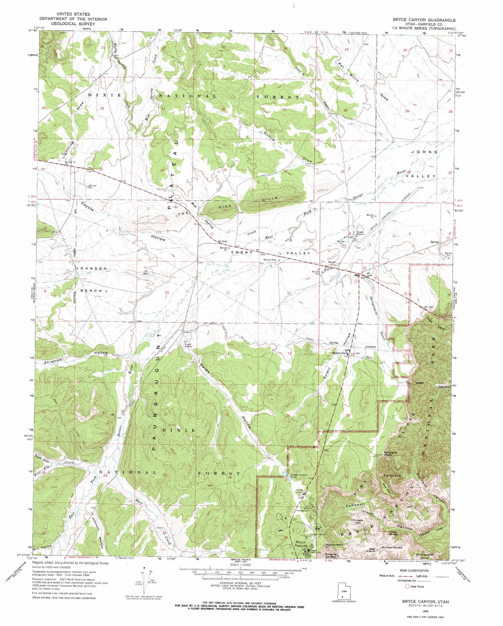
USGS Topo Quad 37112f2 - 1:24,000 scale
| Topo Map Name: | Bryce Canyon |
| USGS Topo Quad ID: | 37112f2 |
| Print Size: | ca. 21 1/4" wide x 27" high |
| Southeast Coordinates: | 37.625° N latitude / 112.125° W longitude |
| Map Center Coordinates: | 37.6875° N latitude / 112.1875° W longitude |
| U.S. State: | UT |
| Filename: | o37112f2.jpg |
| Download Map JPG Image: | Bryce Canyon topo map 1:24,000 scale |
| Map Type: | Topographic |
| Topo Series: | 7.5´ |
| Map Scale: | 1:24,000 |
| Source of Map Images: | United States Geological Survey (USGS) |
| Alternate Map Versions: |
Bryce Canyon UT 1966, updated 1968 Download PDF Buy paper map Bryce Canyon UT 2002, updated 2005 Download PDF Buy paper map Bryce Canyon UT 2011 Download PDF Buy paper map Bryce Canyon UT 2014 Download PDF Buy paper map |
| FStopo: | US Forest Service topo Bryce Canyon is available: Download FStopo PDF Download FStopo TIF |
1:24,000 Topo Quads surrounding Bryce Canyon
Panguitch Nw |
Blind Spring Mountain |
Adams Head |
Cow Creek |
Grass Lakes |
Panguitch |
Casto Canyon |
Flake Mountain West |
Flake Mountain East |
Sweetwater Creek |
Hatch |
Wilson Peak |
Bryce Canyon |
Tropic Canyon |
Pine Lake |
George Mountain |
Tropic Reservoir |
Bryce Point |
Cannonville |
Henrieville |
Alton |
Podunk Creek |
Rainbow Point |
Bull Valley Gorge |
Slickrock Bench |
> Back to 37112e1 at 1:100,000 scale
> Back to 37112a1 at 1:250,000 scale
> Back to U.S. Topo Maps home
Bryce Canyon topo map: Gazetteer
Bryce Canyon: Airports
Bryce Canyon Airport elevation 2313m 7588′Bryce Canyon Heliport elevation 2336m 7664′
Bryce Canyon: Areas
Bryce Amphitheater elevation 2303m 7555′Fairyland elevation 2282m 7486′
Bryce Canyon: Basins
Emery Valley elevation 2322m 7618′Bryce Canyon: Benches
Johnson Bench elevation 2378m 7801′Bryce Canyon: Bridges
Tower Bridge elevation 2206m 7237′Bryce Canyon: Canals
Tropic Ditch elevation 2339m 7673′Bryce Canyon: Cliffs
Chinese Wall elevation 2317m 7601′Fairyland Point elevation 2375m 7791′
Sunrise Point elevation 2434m 7985′
Bryce Canyon: Parks
Pink Cliffs Village elevation 2319m 7608′Bryce Canyon: Pillars
Coliseum elevation 2259m 7411′Palace of the Fairy Queen elevation 2199m 7214′
Queens Castle elevation 2371m 7778′
Bryce Canyon: Populated Places
Bryce Canyon elevation 2422m 7946′Bryce Canyon City elevation 2336m 7664′
Bryce Canyon: Streams
Berry Spring Creek elevation 2360m 7742′Blue Fly Creek elevation 2357m 7732′
East Creek elevation 2353m 7719′
Mud Spring Creek elevation 2319m 7608′
Right Fork Blue Fly Creek elevation 2366m 7762′
Showalter Creek elevation 2300m 7545′
Bryce Canyon: Summits
Boat Mesa elevation 2328m 7637′Crescent Castle (historical) elevation 2273m 7457′
Crescent Castle (historical) elevation 2255m 7398′
Mormon Temple elevation 2327m 7634′
Oastler Castle (historical) elevation 2280m 7480′
Seal Castle elevation 2314m 7591′
The Pine Hills elevation 2397m 7864′
Bryce Canyon: Trails
Fairyland Loop Trail elevation 2266m 7434′Rim Trail elevation 2428m 7965′
Bryce Canyon: Valleys
Ahlstrom Hollow elevation 2345m 7693′Coyote Hollow elevation 2329m 7641′
Daves Hollow elevation 2352m 7716′
Gussie Draw elevation 2317m 7601′
John L Swale elevation 2302m 7552′
Johnson Hollow elevation 2365m 7759′
Lightning Draw elevation 2365m 7759′
Mill Hollow elevation 2373m 7785′
Pat Willis Draw elevation 2300m 7545′
Shinglemill Swale elevation 2318m 7604′
Syrett Hollow elevation 2327m 7634′
Bryce Canyon digital topo map on disk
Buy this Bryce Canyon topo map showing relief, roads, GPS coordinates and other geographical features, as a high-resolution digital map file on DVD: