Panguitch Lake Topo Map Utah
To zoom in, hover over the map of Panguitch Lake
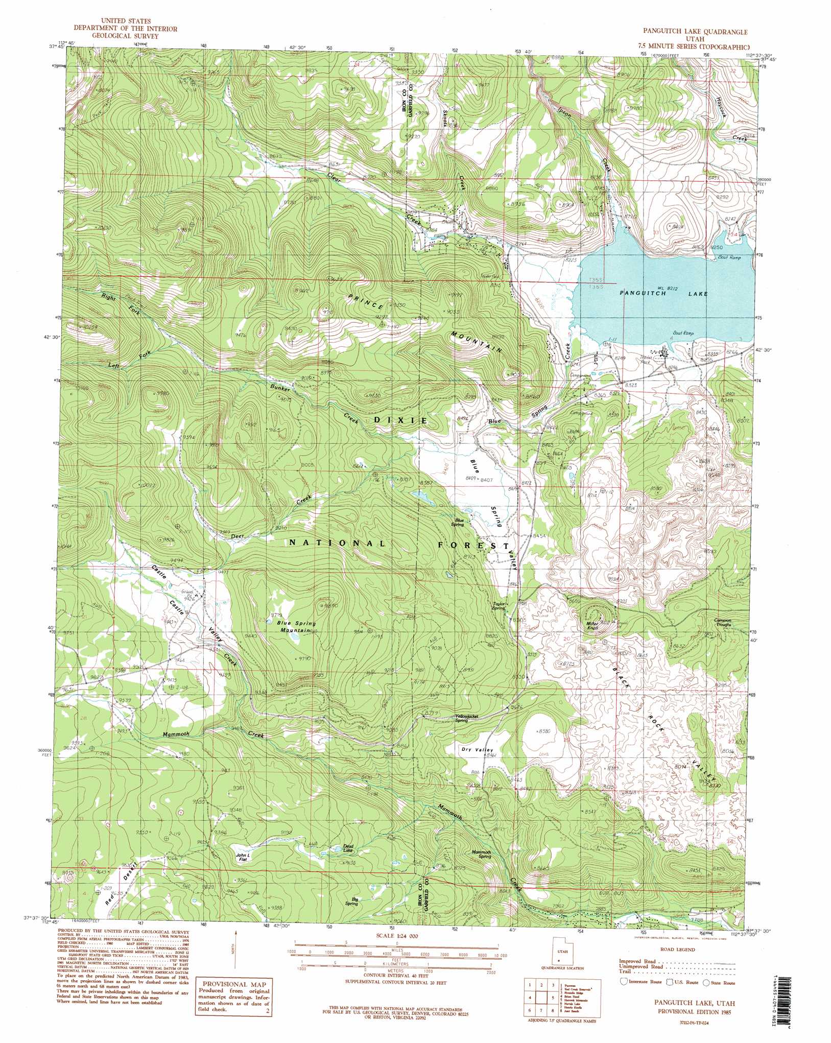
USGS Topo Quad 37112f6 - 1:24,000 scale
| Topo Map Name: | Panguitch Lake |
| USGS Topo Quad ID: | 37112f6 |
| Print Size: | ca. 21 1/4" wide x 27" high |
| Southeast Coordinates: | 37.625° N latitude / 112.625° W longitude |
| Map Center Coordinates: | 37.6875° N latitude / 112.6875° W longitude |
| U.S. State: | UT |
| Filename: | o37112f6.jpg |
| Download Map JPG Image: | Panguitch Lake topo map 1:24,000 scale |
| Map Type: | Topographic |
| Topo Series: | 7.5´ |
| Map Scale: | 1:24,000 |
| Source of Map Images: | United States Geological Survey (USGS) |
| Alternate Map Versions: |
Panguitch Lake UT 1985, updated 1985 Download PDF Buy paper map Panguitch Lake UT 1985, updated 1985 Download PDF Buy paper map Panguitch Lake UT 2002, updated 2005 Download PDF Buy paper map Panguitch Lake UT 2011 Download PDF Buy paper map Panguitch Lake UT 2014 Download PDF Buy paper map |
| FStopo: | US Forest Service topo Panguitch Lake is available: Download FStopo PDF Download FStopo TIF |
1:24,000 Topo Quads surrounding Panguitch Lake
Parowan Gap |
Paragonah |
Cottonwood Mountain |
Little Creek Peak |
Panguitch Nw |
Summit |
Parowan |
Red Creek Reservoir |
Fivemile Ridge |
Panguitch |
Flanigan Arch |
Brian Head |
Panguitch Lake |
Haycock Mountain |
Hatch |
Webster Flat |
Navajo Lake |
Henrie Knolls |
Asay Bench |
George Mountain |
Cogswell Point |
Straight Canyon |
Strawberry Point |
Long Valley Junction |
Alton |
> Back to 37112e1 at 1:100,000 scale
> Back to 37112a1 at 1:250,000 scale
> Back to U.S. Topo Maps home
Panguitch Lake topo map: Gazetteer
Panguitch Lake: Basins
Blue Spring Valley elevation 2566m 8418′Dry Valley elevation 2584m 8477′
Panguitch Lake: Dams
Panguitch Lake Dam elevation 2496m 8188′Panguitch Lake: Flats
John L Flat elevation 2802m 9192′Panguitch Lake: Lakes
Dead Lake elevation 2769m 9084′Panguitch Lake elevation 2504m 8215′
Panguitch Lake: Populated Places
Panguitch Lake Resort elevation 2510m 8234′Panguitch Lake: Reservoirs
Panguitch Lake elevation 2496m 8188′Panguitch Lake: Springs
Big Spring elevation 2758m 9048′Birch Springs elevation 2653m 8704′
Blue Spring elevation 2594m 8510′
Cameron Troughs elevation 2543m 8343′
Mammoth Spring elevation 2502m 8208′
Taylor Spring elevation 2597m 8520′
Yellowjacket Spring elevation 2660m 8727′
Panguitch Lake: Streams
Blue Spring Creek elevation 2509m 8231′Blue Spring Creek elevation 2509m 8231′
Bunker Creek elevation 2561m 8402′
Castle Creek elevation 2748m 9015′
Clear Creek elevation 2509m 8231′
Deer Creek elevation 2571m 8435′
Left Fork Bunker Creek elevation 2780m 9120′
Right Fork Bunker Creek elevation 2780m 9120′
Skoots Creek elevation 2533m 8310′
Tommy Creek elevation 2395m 7857′
Panguitch Lake: Summits
Blue Spring Mountain elevation 3010m 9875′Miller Knoll elevation 2761m 9058′
Prince Mountain elevation 2839m 9314′
Panguitch Lake: Valleys
Castle Valley elevation 2782m 9127′Twin Hollow elevation 2568m 8425′
Panguitch Lake digital topo map on disk
Buy this Panguitch Lake topo map showing relief, roads, GPS coordinates and other geographical features, as a high-resolution digital map file on DVD: