Flake Mountain West Topo Map Utah
To zoom in, hover over the map of Flake Mountain West
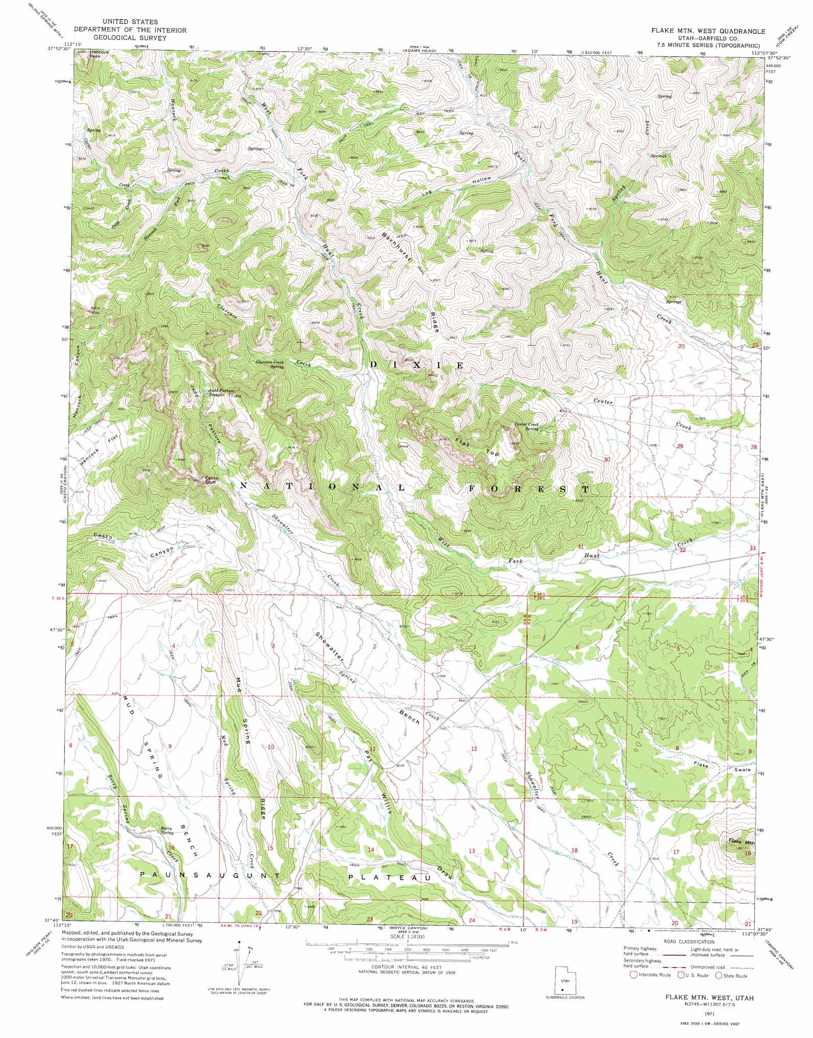
USGS Topo Quad 37112g2 - 1:24,000 scale
| Topo Map Name: | Flake Mountain West |
| USGS Topo Quad ID: | 37112g2 |
| Print Size: | ca. 21 1/4" wide x 27" high |
| Southeast Coordinates: | 37.75° N latitude / 112.125° W longitude |
| Map Center Coordinates: | 37.8125° N latitude / 112.1875° W longitude |
| U.S. State: | UT |
| Filename: | o37112g2.jpg |
| Download Map JPG Image: | Flake Mountain West topo map 1:24,000 scale |
| Map Type: | Topographic |
| Topo Series: | 7.5´ |
| Map Scale: | 1:24,000 |
| Source of Map Images: | United States Geological Survey (USGS) |
| Alternate Map Versions: |
Flake Mtn West UT 1971, updated 1974 Download PDF Buy paper map Flake Mountain West UT 2002, updated 2005 Download PDF Buy paper map Flake Mountain West UT 2011 Download PDF Buy paper map Flake Mountain West UT 2014 Download PDF Buy paper map |
| FStopo: | US Forest Service topo Flake Mountain West is available: Download FStopo PDF Download FStopo TIF |
1:24,000 Topo Quads surrounding Flake Mountain West
Fremont Pass |
Bull Rush Peak |
Mount Dutton |
Deep Creek |
Antimony |
Panguitch Nw |
Blind Spring Mountain |
Adams Head |
Cow Creek |
Grass Lakes |
Panguitch |
Casto Canyon |
Flake Mountain West |
Flake Mountain East |
Sweetwater Creek |
Hatch |
Wilson Peak |
Bryce Canyon |
Tropic Canyon |
Pine Lake |
George Mountain |
Tropic Reservoir |
Bryce Point |
Cannonville |
Henrieville |
> Back to 37112e1 at 1:100,000 scale
> Back to 37112a1 at 1:250,000 scale
> Back to U.S. Topo Maps home
Flake Mountain West topo map: Gazetteer
Flake Mountain West: Benches
Mud Spring Bench elevation 2479m 8133′Showalter Bench elevation 2467m 8093′
Flake Mountain West: Cliffs
Casto Bluff elevation 2813m 9229′Flake Mountain West: Flats
Hancock Flat elevation 2488m 8162′Judd Pasture elevation 2799m 9183′
Flake Mountain West: Lakes
Judd Pasture Troughs elevation 2778m 9114′Flake Mountain West: Ridges
Barnhurst Ridge elevation 2738m 8982′Mud Spring Ridge elevation 2567m 8421′
Flake Mountain West: Springs
Berry Spring elevation 2447m 8028′Center Creek Spring elevation 2566m 8418′
Clarence Creek Spring elevation 2570m 8431′
Flake Mountain West: Streams
Carter Creek elevation 2622m 8602′Clarence Creek elevation 2488m 8162′
Hancock Creek elevation 2572m 8438′
Hancock Fork elevation 2634m 8641′
Judd Creek elevation 2680m 8792′
Spring Creek elevation 2427m 7962′
Spring Creek elevation 2401m 7877′
Flake Mountain West: Summits
Flat Top elevation 2855m 9366′Hancock Peak elevation 3036m 9960′
Flake Mountain West: Valleys
Log Hollow elevation 2488m 8162′Flake Mountain West digital topo map on disk
Buy this Flake Mountain West topo map showing relief, roads, GPS coordinates and other geographical features, as a high-resolution digital map file on DVD: