Fivemile Ridge Topo Map Utah
To zoom in, hover over the map of Fivemile Ridge
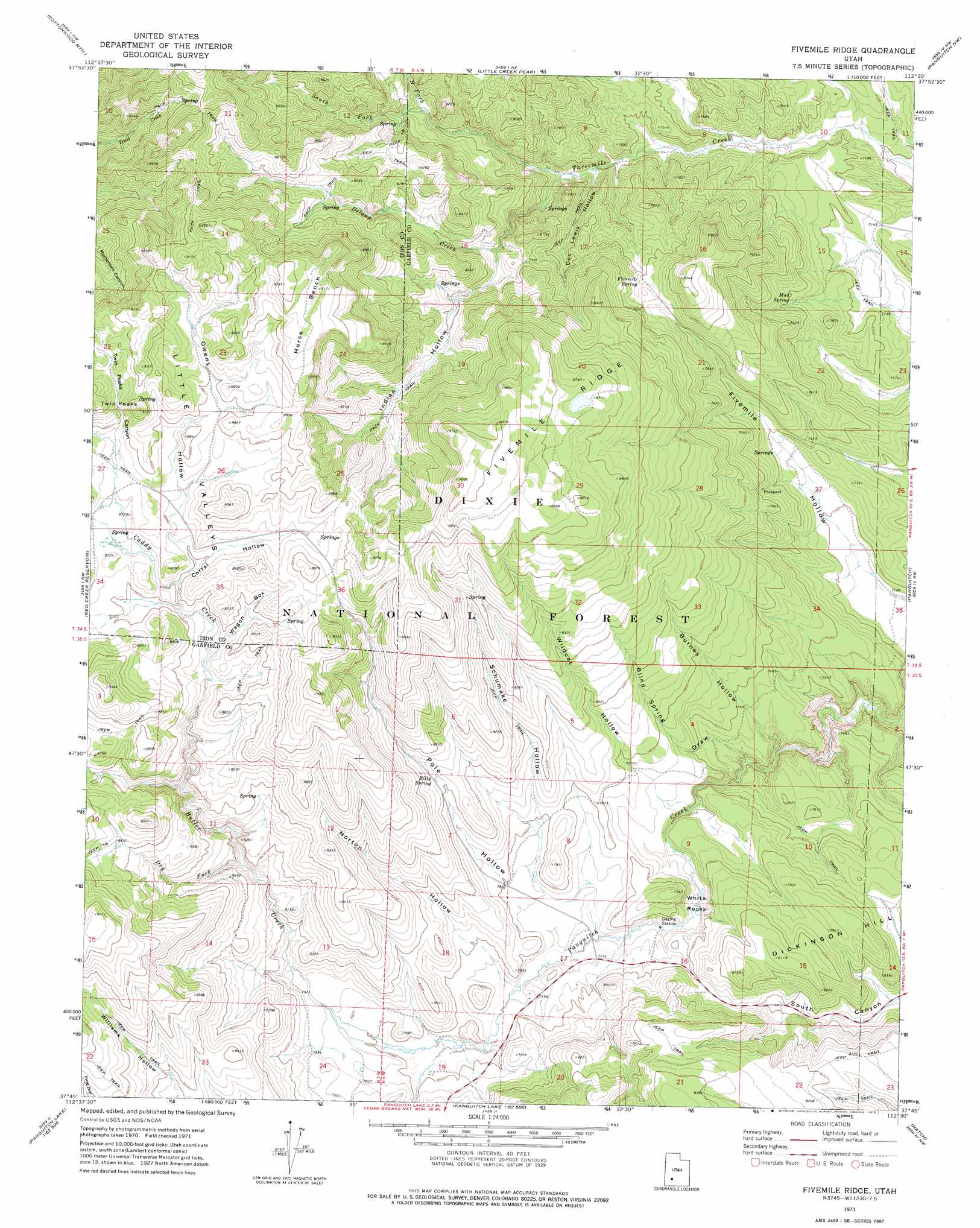
USGS Topo Quad 37112g5 - 1:24,000 scale
| Topo Map Name: | Fivemile Ridge |
| USGS Topo Quad ID: | 37112g5 |
| Print Size: | ca. 21 1/4" wide x 27" high |
| Southeast Coordinates: | 37.75° N latitude / 112.5° W longitude |
| Map Center Coordinates: | 37.8125° N latitude / 112.5625° W longitude |
| U.S. State: | UT |
| Filename: | o37112g5.jpg |
| Download Map JPG Image: | Fivemile Ridge topo map 1:24,000 scale |
| Map Type: | Topographic |
| Topo Series: | 7.5´ |
| Map Scale: | 1:24,000 |
| Source of Map Images: | United States Geological Survey (USGS) |
| Alternate Map Versions: |
Fivemile Ridge UT 1971, updated 1975 Download PDF Buy paper map Fivemile Ridge UT 2002, updated 2005 Download PDF Buy paper map Fivemile Ridge UT 2011 Download PDF Buy paper map Fivemile Ridge UT 2014 Download PDF Buy paper map |
| FStopo: | US Forest Service topo Fivemile Ridge is available: Download FStopo PDF Download FStopo TIF |
1:24,000 Topo Quads surrounding Fivemile Ridge
Jack Henry Knoll |
Buckhorn Flat |
Burnt Peak |
Fremont Pass |
Bull Rush Peak |
Paragonah |
Cottonwood Mountain |
Little Creek Peak |
Panguitch Nw |
Blind Spring Mountain |
Parowan |
Red Creek Reservoir |
Fivemile Ridge |
Panguitch |
Casto Canyon |
Brian Head |
Panguitch Lake |
Haycock Mountain |
Hatch |
Wilson Peak |
Navajo Lake |
Henrie Knolls |
Asay Bench |
George Mountain |
Tropic Reservoir |
> Back to 37112e1 at 1:100,000 scale
> Back to 37112a1 at 1:250,000 scale
> Back to U.S. Topo Maps home
Fivemile Ridge topo map: Gazetteer
Fivemile Ridge: Airports
Panguitch Municipal Airport elevation 2486m 8156′Fivemile Ridge: Benches
Horse Bench elevation 2794m 9166′Fivemile Ridge: Springs
Billy Spring elevation 2454m 8051′Fivemile Spring elevation 2397m 7864′
Mud Spring elevation 2250m 7381′
Tebbs Spring elevation 2550m 8366′
Fivemile Ridge: Streams
Butler Creek elevation 2365m 7759′Caddy Creek elevation 2517m 8257′
Delong Creek elevation 2269m 7444′
Dry Fork elevation 2454m 8051′
North Fork Threemile Creek elevation 2389m 7837′
South Fork Threemile Creek elevation 2389m 7837′
Fivemile Ridge: Summits
Fivemile Ridge elevation 2795m 9169′Twin Peaks elevation 2773m 9097′
White Rocks elevation 2335m 7660′
Fivemile Ridge: Valleys
Blind Spring Draw elevation 2262m 7421′Burnes Hollow elevation 2245m 7365′
Corral Hollow elevation 2621m 8599′
Doc Lewis Hollow elevation 2262m 7421′
Indian Hollow elevation 2386m 7828′
Norton Hollow elevation 2355m 7726′
Owens Hollow elevation 2622m 8602′
Pole Hollow elevation 2366m 7762′
Schumake Hollow elevation 2366m 7762′
Twin Peaks Canyon elevation 2659m 8723′
Wagon Box elevation 2585m 8480′
Wildcat Hollow elevation 2342m 7683′
Fivemile Ridge digital topo map on disk
Buy this Fivemile Ridge topo map showing relief, roads, GPS coordinates and other geographical features, as a high-resolution digital map file on DVD: