Blind Spring Mountain Topo Map Utah
To zoom in, hover over the map of Blind Spring Mountain
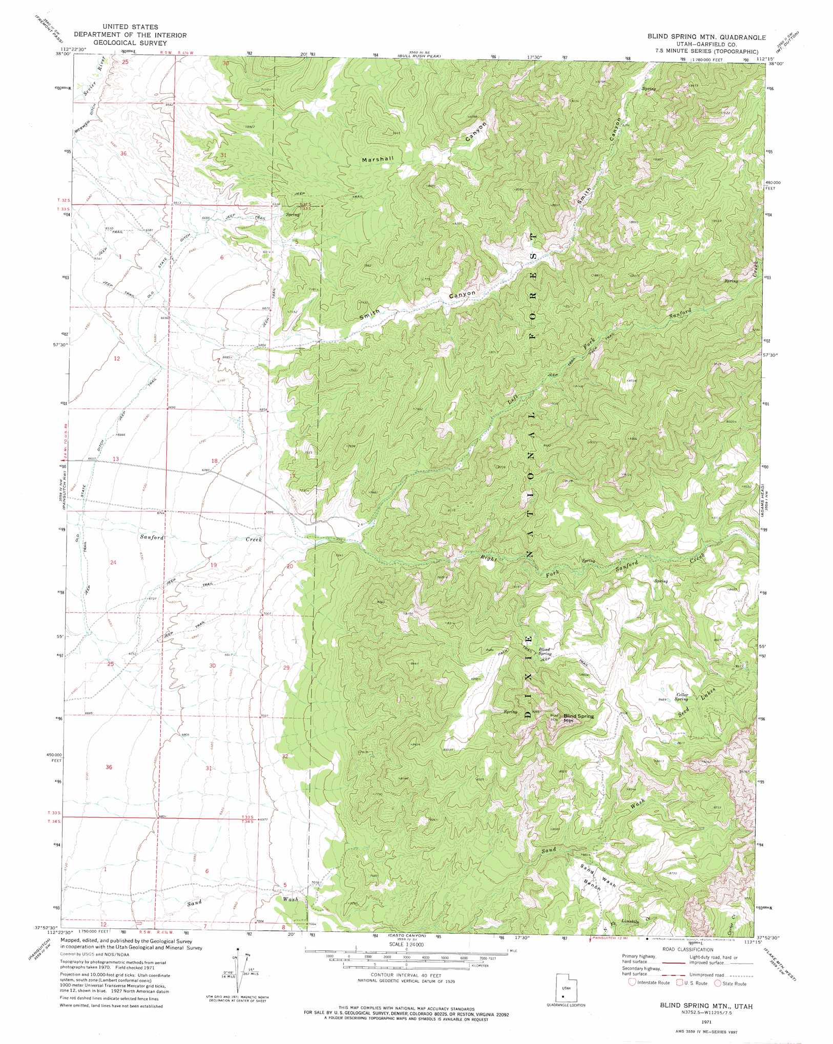
USGS Topo Quad 37112h3 - 1:24,000 scale
| Topo Map Name: | Blind Spring Mountain |
| USGS Topo Quad ID: | 37112h3 |
| Print Size: | ca. 21 1/4" wide x 27" high |
| Southeast Coordinates: | 37.875° N latitude / 112.25° W longitude |
| Map Center Coordinates: | 37.9375° N latitude / 112.3125° W longitude |
| U.S. State: | UT |
| Filename: | o37112h3.jpg |
| Download Map JPG Image: | Blind Spring Mountain topo map 1:24,000 scale |
| Map Type: | Topographic |
| Topo Series: | 7.5´ |
| Map Scale: | 1:24,000 |
| Source of Map Images: | United States Geological Survey (USGS) |
| Alternate Map Versions: |
Blind Spring Mtn UT 1971, updated 1975 Download PDF Buy paper map Blind Spring Mountain UT 2002, updated 2005 Download PDF Buy paper map Blind Spring Mountain UT 2011 Download PDF Buy paper map Blind Spring Mountain UT 2014 Download PDF Buy paper map |
| FStopo: | US Forest Service topo Blind Spring Mountain is available: Download FStopo PDF Download FStopo TIF |
1:24,000 Topo Quads surrounding Blind Spring Mountain
Kane Canyon |
Circleville Mountain |
Circleville |
Junction |
Phonolite Hill |
Burnt Peak |
Fremont Pass |
Bull Rush Peak |
Mount Dutton |
Deep Creek |
Little Creek Peak |
Panguitch Nw |
Blind Spring Mountain |
Adams Head |
Cow Creek |
Fivemile Ridge |
Panguitch |
Casto Canyon |
Flake Mountain West |
Flake Mountain East |
Haycock Mountain |
Hatch |
Wilson Peak |
Bryce Canyon |
Tropic Canyon |
> Back to 37112e1 at 1:100,000 scale
> Back to 37112a1 at 1:250,000 scale
> Back to U.S. Topo Maps home
Blind Spring Mountain topo map: Gazetteer
Blind Spring Mountain: Airports
Pfeiler Ranch Airport elevation 2150m 7053′Blind Spring Mountain: Benches
Sand Wash Bench elevation 2444m 8018′Blind Spring Mountain: Lakes
Seed Lakes elevation 2582m 8471′Blind Spring Mountain: Springs
Blind Spring elevation 2511m 8238′Cellar Spring elevation 2571m 8435′
Blind Spring Mountain: Streams
Left Fork Sanford Creek elevation 2134m 7001′Right Fork Sanford Creek elevation 2134m 7001′
Blind Spring Mountain: Summits
Blind Spring Mountain elevation 2888m 9475′Blind Spring Mountain: Valleys
Marshall Canyon elevation 2071m 6794′Smith Canyon elevation 2110m 6922′
Blind Spring Mountain digital topo map on disk
Buy this Blind Spring Mountain topo map showing relief, roads, GPS coordinates and other geographical features, as a high-resolution digital map file on DVD: