Cottonwood Mountain Topo Map Utah
To zoom in, hover over the map of Cottonwood Mountain
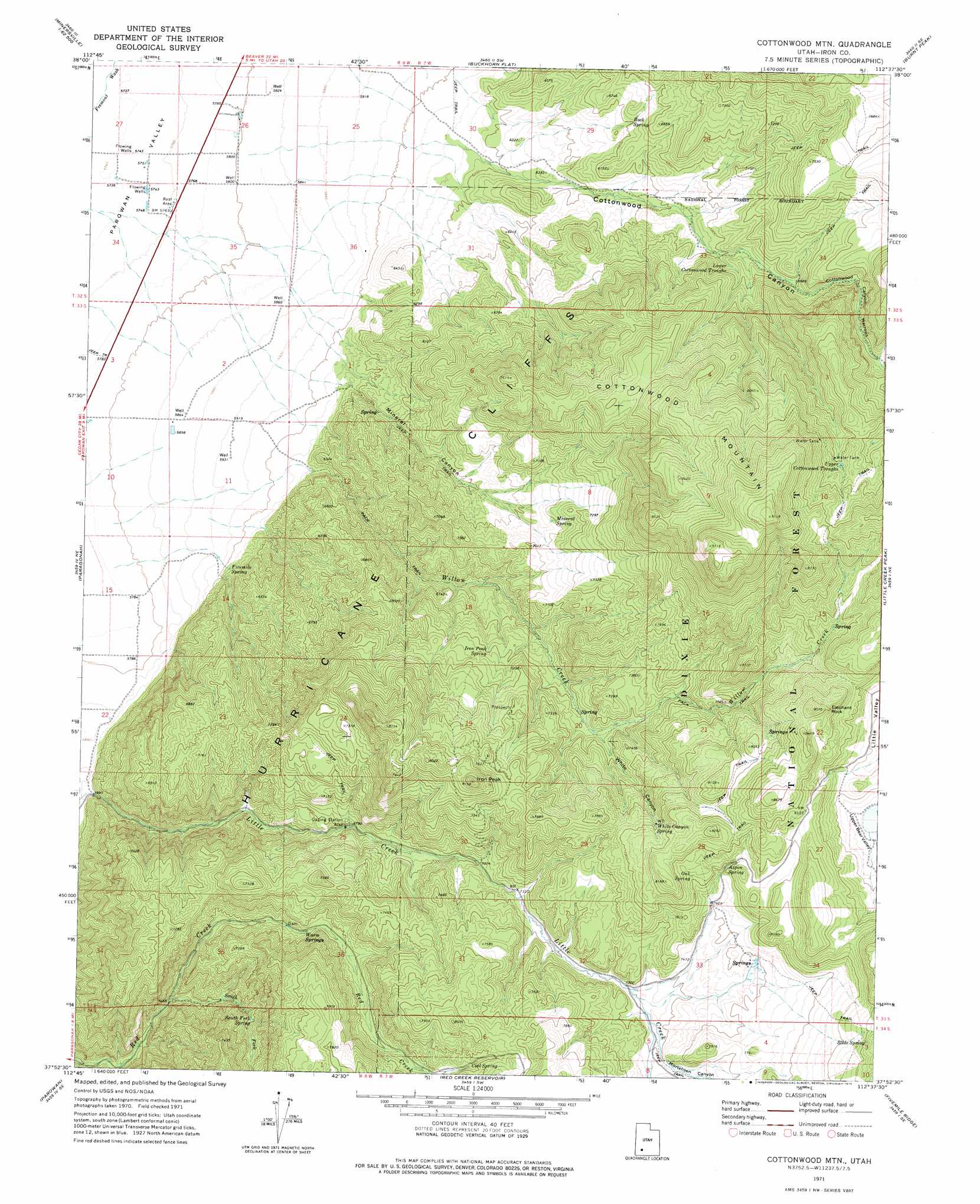
USGS Topo Quad 37112h6 - 1:24,000 scale
| Topo Map Name: | Cottonwood Mountain |
| USGS Topo Quad ID: | 37112h6 |
| Print Size: | ca. 21 1/4" wide x 27" high |
| Southeast Coordinates: | 37.875° N latitude / 112.625° W longitude |
| Map Center Coordinates: | 37.9375° N latitude / 112.6875° W longitude |
| U.S. State: | UT |
| Filename: | o37112h6.jpg |
| Download Map JPG Image: | Cottonwood Mountain topo map 1:24,000 scale |
| Map Type: | Topographic |
| Topo Series: | 7.5´ |
| Map Scale: | 1:24,000 |
| Source of Map Images: | United States Geological Survey (USGS) |
| Alternate Map Versions: |
Cottonwood Mtn UT 1971, updated 1975 Download PDF Buy paper map Cottonwood Mountain UT 2002, updated 2005 Download PDF Buy paper map Cottonwood Mountain UT 2011 Download PDF Buy paper map Cottonwood Mountain UT 2014 Download PDF Buy paper map |
| FStopo: | US Forest Service topo Cottonwood Mountain is available: Download FStopo PDF Download FStopo TIF |
1:24,000 Topo Quads surrounding Cottonwood Mountain
Minersville |
Minersville Reservoir |
Greenville Bench |
Kane Canyon |
Circleville Mountain |
Dry Willow Peak |
Jack Henry Knoll |
Buckhorn Flat |
Burnt Peak |
Fremont Pass |
Parowan Gap |
Paragonah |
Cottonwood Mountain |
Little Creek Peak |
Panguitch Nw |
Summit |
Parowan |
Red Creek Reservoir |
Fivemile Ridge |
Panguitch |
Flanigan Arch |
Brian Head |
Panguitch Lake |
Haycock Mountain |
Hatch |
> Back to 37112e1 at 1:100,000 scale
> Back to 37112a1 at 1:250,000 scale
> Back to U.S. Topo Maps home
Cottonwood Mountain topo map: Gazetteer
Cottonwood Mountain: Gaps
Cottonwood Canyon Narrows elevation 2206m 7237′Cottonwood Mountain: Springs
Aspen Spring elevation 2383m 7818′Cool Spring elevation 2284m 7493′
Fivemile Spring elevation 1861m 6105′
Iron Peak Spring elevation 2144m 7034′
Mineral Spring elevation 2133m 6998′
Oak Spring elevation 2386m 7828′
Rock Spring elevation 2021m 6630′
Slide Spring elevation 2524m 8280′
South Fork Spring elevation 2075m 6807′
Warm Springs elevation 2110m 6922′
White Canyon Spring elevation 2376m 7795′
Cottonwood Mountain: Streams
South Fork Red Creek elevation 1971m 6466′Willow Creek elevation 1767m 5797′
Cottonwood Mountain: Summits
Cottonwood Mountain elevation 2775m 9104′Elephant Rock elevation 2613m 8572′
Iron Peak elevation 2480m 8136′
Cottonwood Mountain: Valleys
Cottonwood Canyon elevation 1886m 6187′Hurricane Fault elevation 2165m 7103′
Mineral Canyon elevation 1876m 6154′
Mortensen Canyon elevation 2256m 7401′
White Canyon elevation 2159m 7083′
Cottonwood Mountain digital topo map on disk
Buy this Cottonwood Mountain topo map showing relief, roads, GPS coordinates and other geographical features, as a high-resolution digital map file on DVD: