Paragonah Topo Map Utah
To zoom in, hover over the map of Paragonah
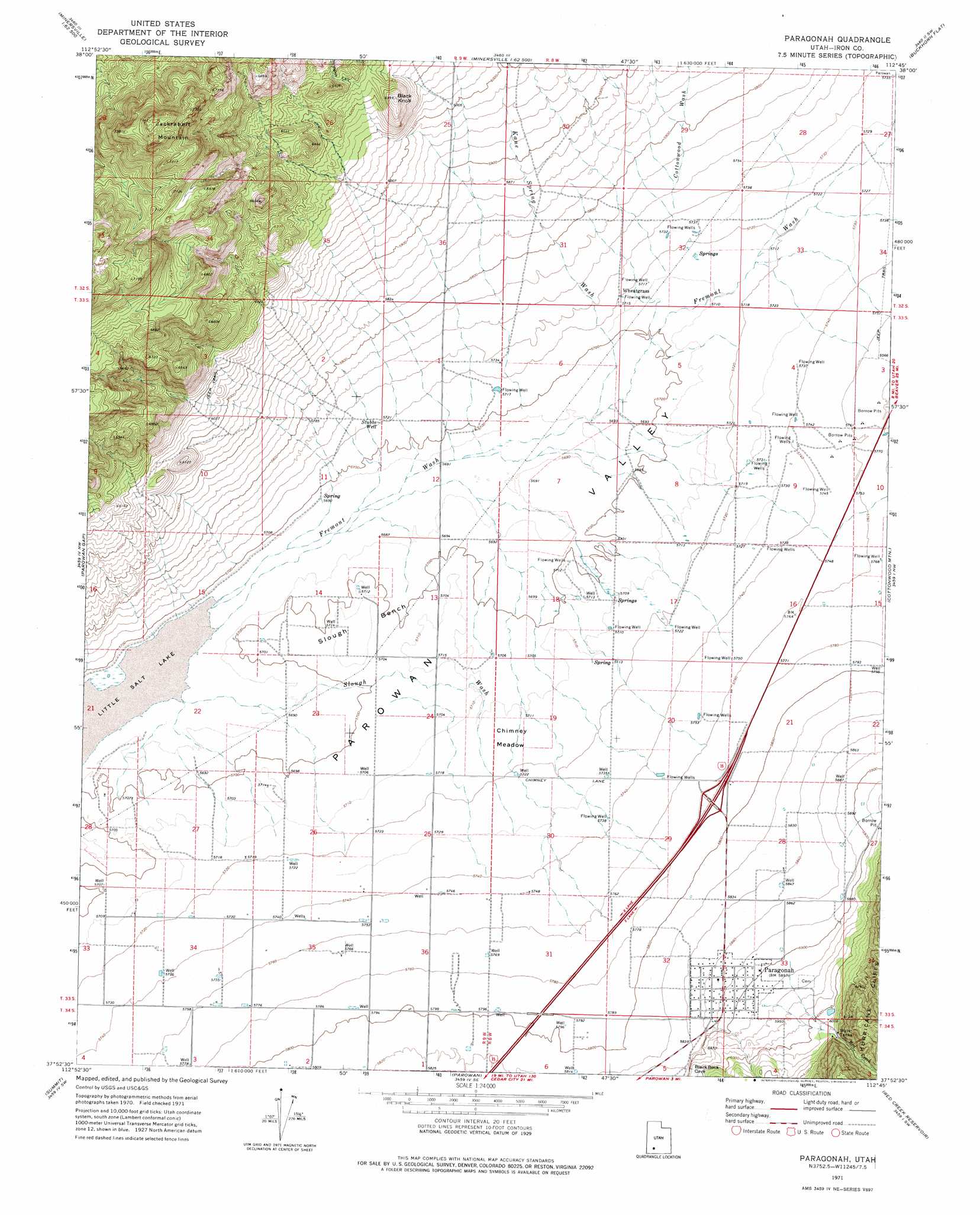
USGS Topo Quad 37112h7 - 1:24,000 scale
| Topo Map Name: | Paragonah |
| USGS Topo Quad ID: | 37112h7 |
| Print Size: | ca. 21 1/4" wide x 27" high |
| Southeast Coordinates: | 37.875° N latitude / 112.75° W longitude |
| Map Center Coordinates: | 37.9375° N latitude / 112.8125° W longitude |
| U.S. State: | UT |
| Filename: | o37112h7.jpg |
| Download Map JPG Image: | Paragonah topo map 1:24,000 scale |
| Map Type: | Topographic |
| Topo Series: | 7.5´ |
| Map Scale: | 1:24,000 |
| Source of Map Images: | United States Geological Survey (USGS) |
| Alternate Map Versions: |
Paragonah UT 1971, updated 1974 Download PDF Buy paper map Paragonah UT 2011 Download PDF Buy paper map Paragonah UT 2014 Download PDF Buy paper map |
1:24,000 Topo Quads surrounding Paragonah
Ninemile Knoll |
Minersville |
Minersville Reservoir |
Greenville Bench |
Kane Canyon |
Baboon Peak |
Dry Willow Peak |
Jack Henry Knoll |
Buckhorn Flat |
Burnt Peak |
Enoch Ne |
Parowan Gap |
Paragonah |
Cottonwood Mountain |
Little Creek Peak |
Enoch |
Summit |
Parowan |
Red Creek Reservoir |
Fivemile Ridge |
Cedar City |
Flanigan Arch |
Brian Head |
Panguitch Lake |
Haycock Mountain |
> Back to 37112e1 at 1:100,000 scale
> Back to 37112a1 at 1:250,000 scale
> Back to U.S. Topo Maps home
Paragonah topo map: Gazetteer
Paragonah: Basins
Parowan Valley elevation 1738m 5702′Paragonah: Benches
Slough Bench elevation 1739m 5705′Paragonah: Flats
Chimney Meadow elevation 1743m 5718′Paragonah: Populated Places
Paragonah elevation 1792m 5879′Wheatgrass elevation 1746m 5728′
Paragonah: Streams
Little Creek elevation 1791m 5875′Red Creek elevation 1807m 5928′
Paragonah: Summits
Black Knoll elevation 1947m 6387′Jackrabbit Mountain elevation 2294m 7526′
Paragonah: Valleys
Cottonwood Wash elevation 1752m 5748′Fremont Wash elevation 1737m 5698′
Kane Spring Wash elevation 1739m 5705′
Slough Wash elevation 1736m 5695′
Stringies Canyon elevation 1918m 6292′
Paragonah: Wells
Stubbs Well elevation 1745m 5725′Paragonah digital topo map on disk
Buy this Paragonah topo map showing relief, roads, GPS coordinates and other geographical features, as a high-resolution digital map file on DVD: