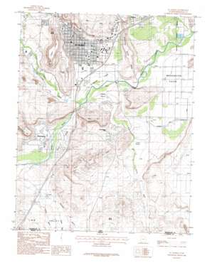
Saint George Topo Map Utah
To zoom in, hover over the map of Saint George
USGS Topo Quad 37113a5 - 1:24,000 scale
| Topo Map Name: | Saint George |
| USGS Topo Quad ID: | 37113a5 |
| Print Size: | ca. 21 1/4" wide x 27" high |
| Southeast Coordinates: | 37° N latitude / 113.5° W longitude |
| Map Center Coordinates: | 37.0625° N latitude / 113.5625° W longitude |
| U.S. State: | UT |
| Filename: | o37113a5.jpg |
| Download Map JPG Image: | Saint George topo map 1:24,000 scale |
| Map Type: | Topographic |
| Topo Series: | 7.5´ |
| Map Scale: | 1:24,000 |
| Source of Map Images: | United States Geological Survey (USGS) |
| Alternate Map Versions: |
St. George SE UT 1956, updated 1956 Download PDF Buy paper map St. George UT 1986, updated 1987 Download PDF Buy paper map St. George UT 1986, updated 1987 Download PDF Buy paper map Saint George UT 2011 Download PDF Buy paper map Saint George UT 2014 Download PDF Buy paper map |
1:24,000 Topo Quads surrounding Saint George
> Back to 37113a1 at 1:100,000 scale
> Back to 37112a1 at 1:250,000 scale
> Back to U.S. Topo Maps home
Saint George topo map: Gazetteer
Saint George: Airports
Saint George Municipal Airport elevation 832m 2729′Saint George: Arroyos
Fort Pearce Wash elevation 771m 2529′Saint George: Basins
Big Valley elevation 805m 2641′Little Valley elevation 800m 2624′
Saint George: Benches
Cottam Bench elevation 796m 2611′Price Bench elevation 771m 2529′
Saint George: Canals
Little Valley Ditch elevation 805m 2641′Price Bench Ditch elevation 782m 2565′
Saint George Valley Lateral elevation 799m 2621′
Santa Clara Saint George Canal elevation 803m 2634′
Saint George: Flats
Saint George Fields elevation 795m 2608′Washington Fields elevation 800m 2624′
Saint George: Gaps
Devils Saddle elevation 954m 3129′Saint George: Parks
Brigham Young Winter Home elevation 844m 2769′Hillside Palms RV Park elevation 857m 2811′
Settlers RV Park elevation 838m 2749′
Temple View RV Resort elevation 796m 2611′
Twin Lakes RV Park elevation 805m 2641′
Saint George: Populated Places
Bloomington elevation 769m 2522′Bloomington Hills elevation 794m 2604′
Middleton elevation 868m 2847′
Saint George elevation 823m 2700′
Southern Trailer Park elevation 846m 2775′
Valley View Trailer Park elevation 873m 2864′
Saint George: Post Offices
Saint George Post Office elevation 836m 2742′Saint George: Ridges
West Black Ridge elevation 1004m 3293′Saint George: Springs
East Saint George Springs elevation 878m 2880′Saint George: Streams
City Creek elevation 814m 2670′Mill Creek elevation 801m 2627′
Santa Clara River elevation 774m 2539′
Saint George: Summits
Bloomington Hill elevation 887m 2910′Nichols Peak elevation 889m 2916′
Price City Hills elevation 931m 3054′
Red Hills elevation 969m 3179′
Sugarloaf elevation 928m 3044′
Webb Hill elevation 947m 3106′
White Dome elevation 872m 2860′
Saint George: Valleys
Big Valley elevation 805m 2641′Halfway Wash elevation 811m 2660′
Lizard Wash elevation 790m 2591′
Lizard Wash elevation 790m 2591′
Middleton Wash elevation 793m 2601′
Mokaac Wash elevation 792m 2598′
Saint George digital topo map on disk
Buy this Saint George topo map showing relief, roads, GPS coordinates and other geographical features, as a high-resolution digital map file on DVD:


